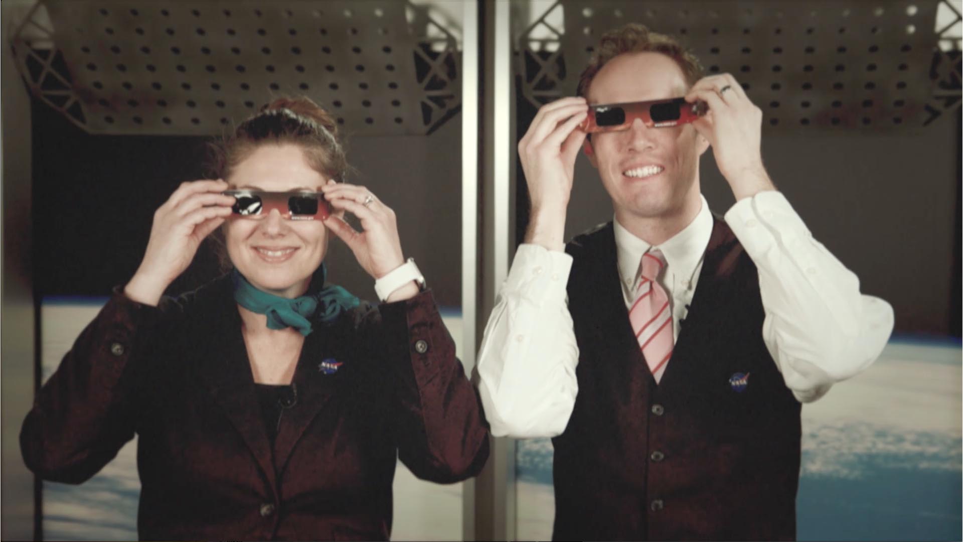
Rare Total Solar Eclipse Is Only Two Months Away Live Shots 6.21.17
- Edited by:
- Michael Randazzo
- Produced by:
- Michelle Handleman
- View full credits
Movies
- eclipse_6_21_17_b-roll.webm (1280x720) [40.3 MB]
- eclipse_6_21_17_b-roll.mov (1280x720) [5.5 GB]
Images
- eclipse_6_21_17_b-roll.00001_print.jpg (1024x576) [85.9 KB]
- eclipse_6_21_17_b-roll.00001_thm.png (80x40) [5.5 KB]
- eclipse_6_21_17_b-roll.00001_searchweb.png (320x180) [50.5 KB]
- eclipse_6_21_17_b-roll.00001_web.png (320x180) [50.5 KB]
B-roll for the live shots
The Countdown is on for Rare Solar Eclipse Visible Across all of North America
For the First Time in Nearly 100 Years, Millions of Americans Coast-to-Coast Will see an Eclipse
Chat with NASA to find out how you can catch this spectacular event
For the First Time in Nearly 100 Years, Millions of Americans Coast-to-Coast Will see an Eclipse
Chat with NASA to find out how you can catch this spectacular event
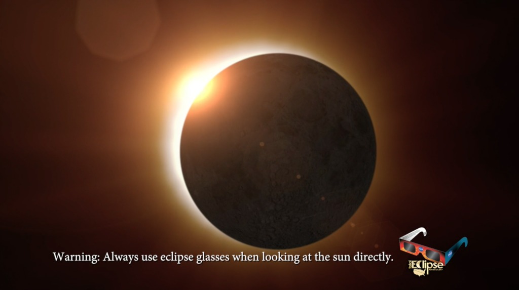
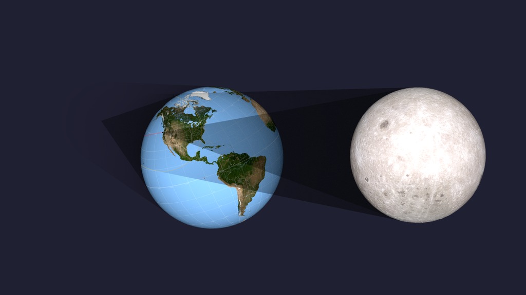
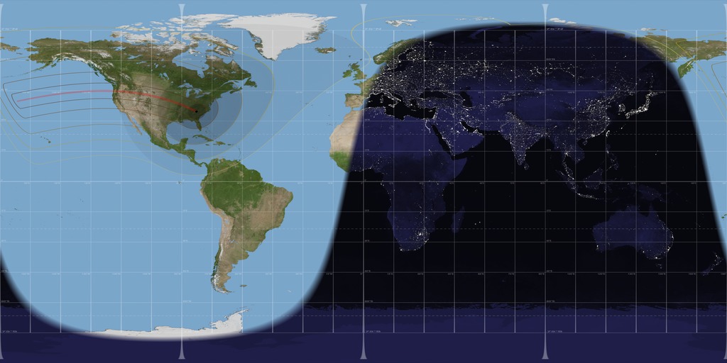
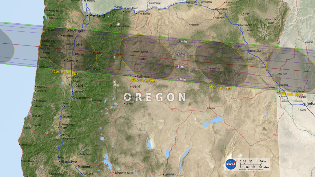
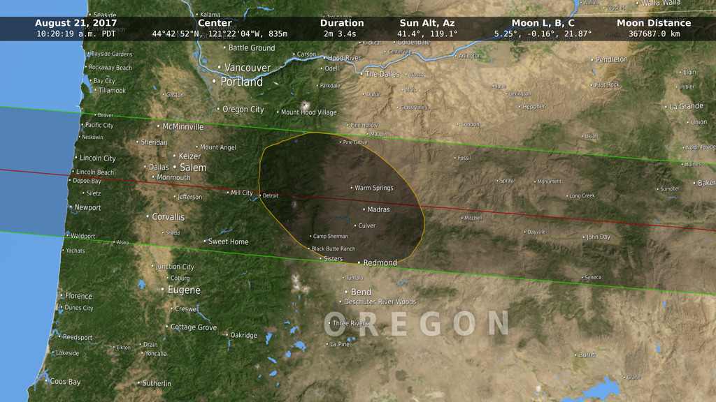
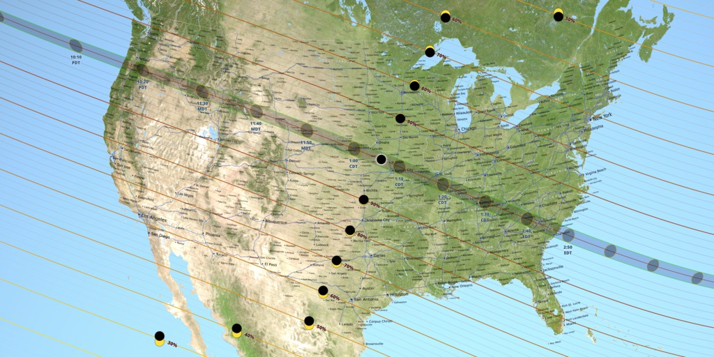
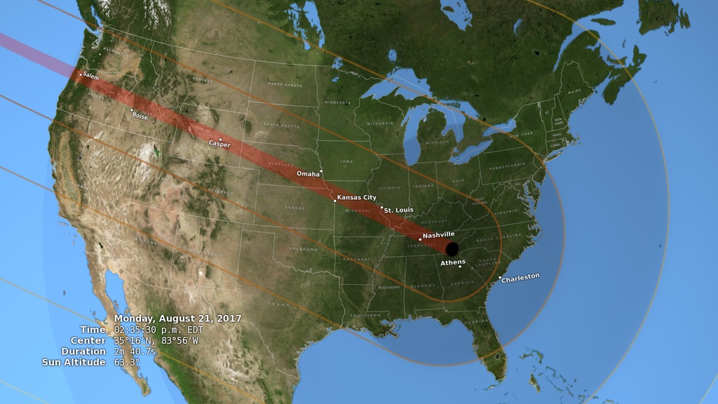
On August 21, 2017, daylight will fade to the level of a moonlit night as millions of Americans experience one of nature’s most awe-inspiring shows – a total solar eclipse. For the first time since 1918, the dark shadow of the moon will sweep coast-to-coast across the United States, putting 14 states in the path of totality and providing a spectacular view of a partial eclipse across all 50 states.
NASA scientists are available Wednesday, June 21, from 6:00 a.m. – 12:00 p.m. ET to show your viewers the path of the eclipse, what they need to see it safely and talk about the unprecedented science that will be gathered from one of the most anticipated and widely observed celestial events in history. We’ll also give your viewers a sneak peek of a press conference about the eclipse NASA is having later that day.
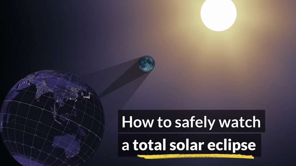
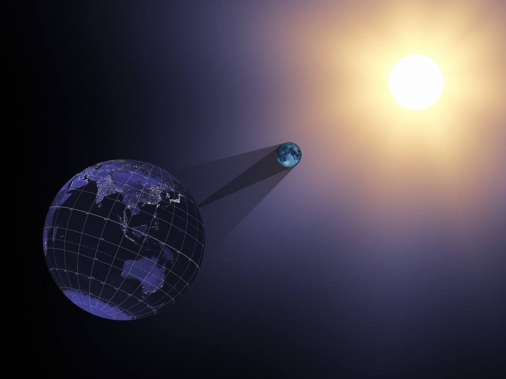
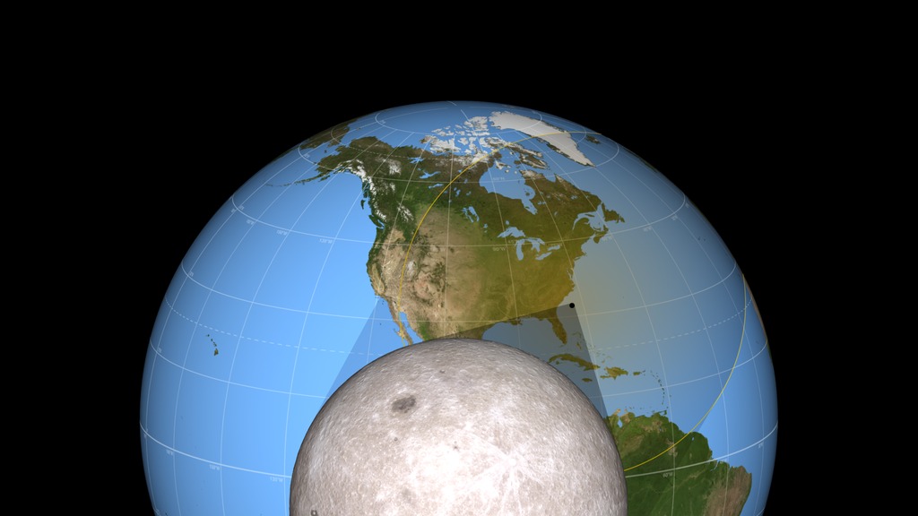
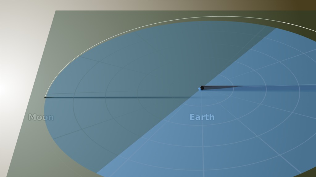
A solar eclipse happens when a rare alignment of the sun and moon casts a shadow on Earth. NASA knows the shape of the moon better than any other planetary body, and this data allows us to accurately predict the shape of the shadow as it falls on the face of Earth. While everyone in the U.S. will see the eclipse if their local skies are clear, people standing in the path of totality – completely in the moon’s shadow – will see stars and planets become visible in what is normally a sunlit sky.
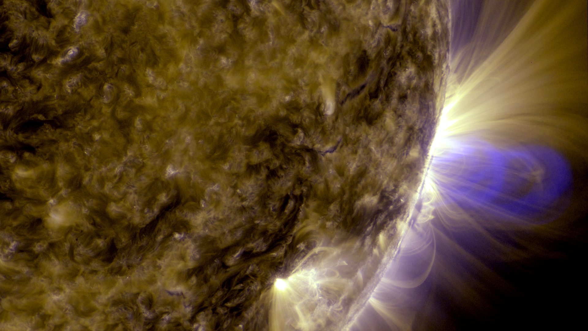
Eclipses provide an unprecedented opportunity for us to see the sun’s faint outer atmosphere in a way that cannot be replicated by current human-made instruments. Scientists believe this region of the sun is the main driver for the sun’s constant outpouring of radiation, known as the solar wind, as well as powerful bursts of solar material that can be harmful to our satellites, orbiting astronauts and power grids on the ground.
HD Satellite Coordinates for G17-K18/LO: Galaxy 17 Ku-band Xp 18 Slot Lower | 91.0 ° W Longitude | DL 12051.0 MHz | Vertical Polarity | QPSK/DVB-S | FEC 3/4 | SR 13.235 Mbps | DR 18.2954 MHz | HD 720p | Format MPEG2 | Chroma Level 4:2:0 | Audio Embedded
**To book a window contact** / Michelle Handleman / michelle.z.handleman@nasa.gov / 301-286-0918
Suggested Questions:
1. This is the first time in nearly 100 years that the United States will have the opportunity to see a total solar eclipse coast-to-coast! What will happen on August 21?
2. This eclipse will be the most widely observed and shared celestial event in U.S. history. Why are scientists excited for this eclipse?
3. Eclipses allow scientists to see the sun’s faint outer atmosphere, which is actually hotter than its surface. What can you tell us about NASA’s upcoming mission that will touch the sun?
4. How does NASA’s study of our sun help us explore the solar system?
5. How does NASA’s mapping of the moon give us the accurate path of totality?
6. Where can we learn more?
Live Shot Details:
Location: NASA’s Goddard Space Flight Center/Greenbelt, Maryland
Scientists:
Dr. Alex Young / NASA Scientist
Dr. Nicholeen Viall / NASA Scientist
Dr. Noah Petro / NASA Scientist
Dr. Geronimo Villanueva [in Spanish] / NASA Scientist
To learn more visit:
Eclipse Across America
On Twitter @NASASun
Movies
- NickiViallCannedSide.mp4 (1280x720) [554.6 MB]
- NickiViallCannedSide.webm (1280x720) [39.3 MB]
- NickiViallCannedSide.mov (1920x1080) [8.7 GB]
Captions
- NickiViallCannedSide.en_US.vtt [6.8 KB]
- NickiViallCannedSide.en_US.srt [6.8 KB]
Images
- NickiViallCannedSide.00001_print.jpg (1024x576) [26.6 KB]
Canned interview with NASA Scientist Dr. Nicholeen Viall looking off camera. Soundbites are separated by slates. Includes transcript of soundbites.
Canned interview in Spanish with Dr. Yari Collado-Vega. Soundbites are separated with slates
Soundbites with Drs. Alex Young and Noah Petro. TRT 5:41. Includes full transcript with timecodes
For More Information
Credits
Please give credit for this item to:
NASA's Goddard Space Flight Center
Editor
- Michael Randazzo (AIMM) [Lead]
Producers
- Michelle Handleman (KBRwyle) [Lead]
- Clare Skelly (NASA/GSFC)
Series
This visualization can be found in the following series:Related pages
One Month & Counting: Solar Eclipse Liveshots (July 21, 2017)
July 10th, 2017
Read moreCanned interviews will be available by 6:00 p.m. ET on July 20, 2017. B-roll package for liveshot. Canned soundbites with Dr. Alex Young. TRT 4:59. Includes full transcript answering the following questions:1. What’s going to happen one month from today? [answer includes safety information]2. Why is this eclipse special to NASA?3. How can our viewers participate?4. We live on a solar powered planet. How does energy from the sun impact Earth?5. How can we safely view the eclipse?6. Where can we learn more? Soundbites with NASA Scientist Dr. Michelle Thaller looking off camera. TRT 4:06. Includes full text of the soundbites. SOTs are separated by a slate. She answers the following questions:1. What's going to happen one month from today?2. What's it like to see an eclipse?3. How can we view the eclipse safely?4. How can our viewers participate?5. What is NASA's new mission that will collect information on the sun-Earth relationship? One Month and Counting: Solar Eclipse Visible From Everywhere in North AmericaBecome a Citizen Scientist During the Eclipse, Using the GLOBE Phone AppHelp Scientists Study What Happens When Earth Goes Dark During the Solar EclipseOne of the most anticipated solar eclipses in history is just a month away. The August 21 solar eclipse provides a unique opportunity to study our planet and what happens when Earth goes dark during an eclipse. It’s also an opportunity for what may be the largest citizen science project of all time.On that Monday, the moon’s shadow will darken the sky, causing temperatures to drop and stars to become visible in the normally day lit sky. This brief hiccup in the usual day-night cycle changes the amount of energy an area gets from the sun.NASA scientists hope to learn just how much Earth’s environment changes during this historic eclipse and they need help from your viewers! Using the GLOBE Observer phone application, curious eclipse onlookers can become citizen scientists. This resulting data will help us better understand the important relationship between the sun and Earth.Join NASA scientists on Friday, July 21 from 6:00 a.m. – 12:00 p.m. ET to find out where your viewers can see the eclipse and how they can participate, whether they’re viewing from the path of totality or not!Everyone in North America (weather dependent) will experience an eclipse, one of nature’s rarest shows – even those outside the path of totality. For the first time since 1918, the dark shadow of the moon will sweep coast-to-coast across the United States, putting 14 states in the path of totality and providing a spectacular view of a partial eclipse across all 50 states.HD Satellite Coordinates for G17-K18/LO: Galaxy 17 Ku-band Xp 18 Slot Lower| 91.0 ° W Longitude | DL 12051.0 MHz | Vertical Polarity | QPSK/DVB-S | FEC 3/4 | SR 13.235 Mbps | DR 18.2954 MHz | HD 720p | Format MPEG2 | Chroma Level 4:2:0 | Audio Embedded*** To book a window contact*** Clare Skelly / clare.a.skelly@nasa.gov / (301) 286-4994Suggested Questions:1. What’s going to happen one month from today? [answer includes safety information]2. Why is this eclipse special to NASA?3. How can our viewers participate?4. We live on a solar powered planet. How does energy from the sun impact Earth?5. Where can we learn more?Extra Questions for Longer Interviews:6. Tell us about the new mission NASA is preparing to launch that will continue to collect information on the sun-Earth relationship.7. Can solar eclipses be seen from other planets and what do they look like?8. An eclipse is a type of transit. How can astronomers use transits to detect planets orbiting other stars?Location: NASA’s Goddard Space Flight Center / Greenbelt, MarylandScientists:Dr. Michelle Thaller / NASA ScientistDr. Jim Garvin / NASA ScientistDr. Alex Young / NASA ScientistDr. Ivona Cetinic / NASA ScientistVideo: NASA will roll all insert videos during live interviews. If needed, stations can roll a clean feed of all video at 5:45 a.m. ET on July 21, 2017, at the above listed satellite.Download the GLOBE Observer Application for iOS or Android.For eclipse information, maps and safety: https://eclipse2017.nasa.gov/To learn more about the GLOBE program: https://observer.globe.gov/For more information about how NASA studies Earth: https://www.nasa.gov/earth For More InformationSee [https://eclipse2017.nasa.gov/](https://eclipse2017.nasa.gov/) Related pages
2017 Solar Eclipse Press Conference
June 21st, 2017
Read moreThe Total Eclipse of the Sun Forever Stamp, which commemorates the Aug. 21, 2017, eclipse, transforms into an image of the moon from the heat of a finger. For more information visit The United States Postal Service. The 2017 total solar eclipse through the eyes of NASA with a list of NASA broadcasts. Credit: NASA The 2017 total solar eclipse through the eyes of NASA. Credit: NASA An infographic showing NOAA-related satellites. Credit: NOAA. For more information visit NOAA's Satellite and Information Service. The average historic cloudiness for Aug. 21. Credit: NOAA. For more information visit NOAA's Centers for Environmental Information. Wearing eclipse glasses is vital when looking directly at the sun. Credit: National Park Service. For more information visit the National Park Service. A partial eclipse. Credit: National Park Service. For more information visit the National Park Service. A crowd watches a solar eclipse. Credit: National Park Service. For more information visit the National Park Service. Interstates along the path of the 2017 total solar eclipse. Credit: DOT. For more information visit FHWA's Total Solar Eclipse Website. Eclipse ballooning project. Credit: Montana State University. For more information visit Montana State's Eclipse Ballooning project. A balloon 'float' demonstration at 84,000 feet on April 19, 2014. Credit: Montana State University. For more information visit Montana State's Eclipse Ballooning project. Animals can react to eclipses -- such as this bird during an annular eclipse --as if it's nighttime. Credit: AAS Multiple eclipse shadows cast on the ground due to sunlight from an eclipse filtering through tree leaves. Credit: AAS Sunspots. Credit: NSF A total solar eclipse. Credit: NSF A combined image from NASA's Solar Dynamics Observatory (center) and ESA/NASA's Solar and Heliospheric Observatory (outer) shows solar radiation streaming off the sun out into space. Credit: NASA/ESA/SDO/SOHO For the first time in 99 years, a total solar eclipse will cross the entire nation Aug. 21. Representatives from NASA, other federal agencies, and science organizations, will provide important viewing safety, travel and science information during two briefings at the Newseum in Washington starting at 1 p.m. EDT Wednesday, June 21.The event will air live on NASA Television and stream on the agency’s website.Over the course of 100 minutes, 14 states across the United States will experience more than two minutes of darkness in the middle of the day. Additionally, a partial eclipse will be viewable across all of North America. The eclipse will provide a unique opportunity to study the sun, Earth, moon and their interaction because of the eclipse’s long path over land coast to coast. Scientists will be able to take ground-based and airborne observations over a period of an hour and a half to complement the wealth of data and images provided by space assets.The June 21 briefings are:Logistics Briefing: 1 to 2 p.m.Thomas Zurbuchen, associate administrator of NASA’s Science Mission Directorate at the agency’s headquarters in WashingtonVanessa Griffin, director of the National Oceanic and Atmospheric Administration’s Office of Satellite and Product Operations in Suitland, MarylandBrian Carlstrom, deputy associate director of Natural Resource Stewardship and Science at the National Park Service in WashingtonMartin Knopp, associate administrator of the Office of Operations in the Federal Highway Administration at the U.S. Department of Transportation in WashingtonScience Briefing: 2:30 to 3:30 p.m.Thomas ZurbuchenAngela Des Jardins, principal investigator of the Eclipse Ballooning Project at Montana State University, BozemanAngela Speck, professor of astrophysics and director of astronomy at the University of Missouri, ColumbiaDave Boboltz, program director of solar physics in the Division of Astronomical Sciences at the National Science Foundation in Arlington, VirginiaLinda Shore, executive director of the Astronomical Society of the Pacific in San FranciscoMatt Penn, astronomer at the National Solar Observatory in Tucson, Arizona For More InformationSee [https://eclipse2017.nasa.gov](https://eclipse2017.nasa.gov) Related pages
How to Safely Watch a Solar Eclipse
June 21st, 2017
Read moreComplete transcript available.Watch this video on the NASA Goddard YouTube channel. It is never safe to look directly at the sun's rays – even if the sun is partly obscured. When watching a partial eclipse you must wear eclipse glasses at all times if you want to face the sun, or use an alternate indirect method. This also applies during a total eclipse up until the time when the sun is completely and totally blocked.During the short time when the moon completely obscures the sun – known as the period of totality – it is safe to look directly at the star, but it's crucial that you know when to take off and put back on your glasses.First and foremost: Check for local information on timing of when the total eclipse will begin and end. NASA's page of eclipse times is a good place to start. Second: The sun also provides important clues for when totality is about to start and end.Learn more at https://eclipse2017.nasa.govFind more videos about the solar ecilpse on the Sun Eclipse 2017 gallery page. For More InformationSee [https://www.nasa.gov/content/eye-safety-during-a-total-solar-eclipse](https://www.nasa.gov/content/eye-safety-during-a-total-solar-eclipse) Related pages
2017 Solar Eclipse Video File
June 21st, 2017
Read moreVideo file for the 2017 eclipse Slug: NASA Gears up for August 21, 2017, Eclipse Across AmericaDescription: On Monday, Aug. 21, 2017, a total eclipse will cross the entire country, coast-to-coast, for the first time since 1918. Weather permitting, the entire continent will have the opportunity to view an eclipse as the moon passes in front of the sun, casting a shadow on Earth’s surface. The total solar eclipse begins near Lincoln City, Oregon, at 10:15 a.m. PDT (1:15 p.m. EDT). Totality ends at 2:48 p.m. EDT near Charleston, South Carolina. The total eclipse itself will take about one hour and 40 minutes to cross the country. Observers outside this path will still see a partial solar eclipse where the moon covers part of the sun's disk. All of North America will have a view of at least a partial eclipse. Super(s): NASACenter Contact: Karen Fox, karen.c.fox@nasa.gov, 301-286-6284HQ Contact: Dwayne Brown, dwayne.c.brown@nasa.gov, 202-358-1726For more information: https://eclipse2017.nasa.gov/ For More InformationSee [eclipse2017.nasa.gov](eclipse2017.nasa.gov) Related pages
Flying Around The Eclipse Shadow
June 21st, 2017
Read moreA view of the Moon's shadow during the August 21, 2017 eclipse from both the night and day sides of the Earth. This visualization combines the views from several previous visualizations (#4390, #4321, and #4314) to create a continuous camera flight from the night side of the Earth to the day side, showing the relationship of the Earth, Moon, and Sun during the August 21, 2017 eclipse. It shows the direction of the Moon's motion and the Earth's rotation, the complete path of the umbra from the moment it touches down on the Earth until the moment it departs, and the true scale of the Earth-Moon system. For More InformationSee [eclipse2017.nasa.gov](eclipse2017.nasa.gov) Related pages
Watching the Friendly Skies - Eclipse Safety Tutorial
June 20th, 2017
Read moreMusic Credit: Chic to Chic by Piero PiccioniWatch this video on the NASA Goddard YouTube channel.Complete transcript available. Glasses on! GIF 15 second clip illustrating various indirect viewing methods for eclipses. No audio. Get ready to view the solar eclipse with these helpful safety tips. No one should ever look directly at the sun, even during an eclipse. Many options for indirect viewing are outlined in this video.A solar eclipse occurs when the moon blocks any part of the sun. On Monday, August 21, 2017, a solar eclipse will be visible (weather permitting) across all of North America. The whole continent will experience a partial eclipse lasting 2 to 3 hours. Halfway through the event, anyone within a roughly 70-mile-wide path from Oregon to South Carolina will experience a brief total eclipse, when the moon completely blocks the sun’s bright face for up to 2 minutes 40 seconds, turning day into night and making visible the otherwise hidden solar corona — the sun’s outer atmosphere — one of nature’s most awesome sights. Bright stars and planets will become visible as well.Learn more at https://eclipse2017.nasa.govFind more videos about the solar ecilpse on the Sun Eclipse 2017 Gallery page. Related pages
August 21, 2017 Total Solar Eclipse Path for Spherical Displays
Feb. 14th, 2017
Read moreA map-like view of the Earth during the total solar eclipse of August 21, 2017, showing the umbra (black oval), penumbra (concentric shaded ovals), and the path of totality (red). This equirectangular projection is suitable for spherical displays and for spherical mapping in 3D animation software. On Monday, August 21, 2017, the Moon will pass in front of the Sun, casting its shadow across all of North America. This will be the first total solar eclipse visible in the contiguous United States in 38 years.The Moon's shadow can be divided into areas called the umbra and the penumbra. Within the penumbra, the Sun is only partially blocked, and observers experience a partial eclipse. The much smaller umbra lies at the very center of the shadow cone, and anyone there sees the Moon entirely cover the Sun in a total solar eclipse.In the animation, the umbra is the small black oval. The red streak behind this oval is the path of totality. Anyone within this path will see a total eclipse when the umbra passes over them. The much larger shaded bullseye pattern represents the penumbra. Steps in the shading denote different percentages of Sun coverage (eclipse magnitude), at levels of 90%, 75%, 50% and 25%. The yellow and orange contours map the path of the penumbra. The outermost yellow contour is the edge of the penumbra path. Outside this limit, no part of the Sun is covered by the Moon.The animation covers the four hours from 16:25:40 UTC to 20:25:30 UTC with time steps of 10 seconds between frames. Related pages
2017 Eclipse State Maps
Feb. 5th, 2017
Read moreOregon Montana Idaho Wyoming Nebraska Iowa Kansas Missouri Illinois Kentucky Tennessee Georgia North Carolina South Carolina The path of totality passes through 14 states during the total solar eclipse on August 21, 2017. A map of each of these states, created for NASA's official eclipse 2017 website, is presented here. Except for Montana, each map is 8 inches wide (or high) at 300 DPI. The umbra is shown at 3-minute intervals, with times in the local time zone at the umbra center. The duration of totality is outlined in 30-second increments. Interstate highways are blue, other major roads are red, and secondary roads are gray.Some sources list only 12 states for this eclipse, but in fact the path of totality also grazes the southwestern borders of both Montana and Iowa. The Montana part of the path is in a roadless area at the southern end of the Beaverhead Mountains, a range that defines sections of both the Montana-Idaho border and the Continental Divide. The Iowa part of the path is west of Interstate 29 near Hamburg, south of 310 Street, and bounded on the west by the Missouri River. It includes the Lower Hamburg Bend Wildlife Management Area. For More InformationSee [http://eclipse2017.nasa.gov](http://eclipse2017.nasa.gov) Related pages
2017 Path of Totality
Dec. 12th, 2016
Read moreThis visualization closely follows the Moon's umbra shadow as it passes over the United States during the August 21, 2017 total solar eclipse. It covers the one hour and 40 minutes between 10:12 am PDT and 2:52 pm EDT. Through the use of a number of NASA datasets, notably the global elevation maps from Lunar Reconnaissance Orbiter, the shape and location of the shadow is depicted with unprecedented accuracy. This animation of the August, 2017 umbra path begins at 2:45 p.m. EDT, when the umbra is about to leave land and travel into the Atlantic Ocean, and it ends at 4:02 p.m. EDT as the umbra is about to leave the Earth's surface. During the August 21, 2017 total solar eclipse, the Moon's umbral shadow will fly across the United States, from Oregon to South Carolina, in a little over 90 minutes. The path of this shadow, the path of totality, is where observers will see the Moon completely cover the Sun for about two and a half minutes.People traveling to see totality, likely numbering in the millions for this eclipse, will rely on maps that show the predicted location of this path. The math used to make eclipse maps was worked out by Friedrich Wilhelm Bessel and William Chauvenet in the 19th century, long before computers and the precise astronomical data gathered during the Space Age.In keeping with their paper and pencil origins, traditional eclipse calculations pretend that all observers are at sea level and that the Moon is a smooth sphere centered on its center of mass. Reasonably accurate maps, including this one, are drawn based on those simplifying assumptions. Those who want greater accuracy are usually referred to elevation tables and plots of the lunar limb.This animation shows the umbra and its path in a new way. Elevations on the Earth's surface and the irregular lunar limb (the silhouette edge of the Moon's disk) are both fully accounted for, and they both have dramatic and surprising effects on the shape of the umbra and the location of the path. To read more about these effects, go here.The animation provides an overhead view of the umbra and runs at a rate of 30× real time — every minute of the eclipse takes two seconds in the animation. For an oblique view that emphasizes the terrain of the path, go here.Earth radius6378.137 kmEllipsoidWGS84GeoidEGM96Moon radius1737.4 kmSun radius696,000 km (959.645 arcsec at 1 AU)EphemerisDE 421Earth orientationearth_070425_370426_predict.bpc (ΔT corrected)Delta UTC69.184 seconds (TT – TAI + 37 leap seconds)ΔT68.917 seconds For More InformationSee [http://eclipse2017.nasa.gov](http://eclipse2017.nasa.gov) Related pages
2017 Total Solar Eclipse Map and Shapefiles
Dec. 12th, 2016
Read moreA map of the United States showing the path of totality for the August 21, 2017 total solar eclipse. This is version 2 of the map, available at both 5400 × 2700 and 10,800 × 5400. A global map of the path of totality for the August 21, 2017 total solar eclipse. A map of the United States showing the path of totality for the August 21, 2017 total solar eclipse. The shapes of the umbra and penumbra, provided in ESRI shapefile format suitable for use in GIS software. The umbra, path, and center line in shapefile format for use in GIS software. This shapefile set is intended for larger scale (higher resolution) mapping. The preview image shows the umbra at 90-second intervals as it passes through Nebraska. Map of the 1918 total solar eclipse, from the American Ephemeris and Nautical Almanac for the Year 1918. This is a scan from the copy of the almanac held by the NASA Goddard library. Map of the 1979 total solar eclipse, from the American Ephemeris and Nautical Almanac. This is a scan from Ernie Wright's personal copy of U.S. Naval Observatory Circular No. 157. This map of the United States shows the path of the Moon's umbral shadow — the path of totality — during the total solar eclipse on August 21, 2017, as well as the obscuration (the fraction of the Sun's area covered by the Moon) in places outside the umbral path. Features include state boundaries, major highways, and 833 place names. At 18" × 9" (45 × 22.5 cm), the scale of the map is approximately 1:10,000,000.The umbra is shown at 10-minute intervals. Umbra shapes within U.S. time zones are labeled in local time. To read about the reason the shapes aren't smooth ovals, go here.The map uses a number of NASA data products. The land color is based on Blue Marble Next Generation, a global mosaic of MODIS images assembled by NASA's Earth Observatory. Elevations are from SRTM, a radar instrument flown on Space Shuttle Endeavour during the STS-99 mission. Lunar topography, used for precise shadow calculations, is from NASA LRO laser altimetry and JAXA Kaguya stereo imaging. Planetary positions are from the JPL DE421 ephemeris. The lunar limb profile and eclipse calculations are by the visualizer. ShapefilesThe map was rendered in animation software, but maps are more typically created using GIS tools and vector datasets. A set of shapefiles describing the umbra and penumbra extents is provided below in two Zip archives, one for global, U.S., and statewide maps and the other for county and city scale mapping. eclipse2017_shapefiles.zip contains the following nine shapefiles:penum17 contains the contours for maximum obscuration at 90%, 75%, 50%, 25% and the penumbra edge at 0%.penum17_1m contains a time sequence of penumbra outlines at 1-minute intervals from 17:00 to 19:15 UTC, for 95% to 75% obscuration in 5% steps.upath17 and w_upath17 contain the path of totality. The w_ version is the complete (world) path, at somewhat reduced resolution, while the other is a high-resolution version of the path limited to the 96 degrees of longitude centered on the U.S.umbra17 and w_umbra17 contain umbra shapes spaced at 10-minute intervals, again at U.S. and world (w_) scales.w_umbra17_1m contains umbra shapes at 1-minute intervals from 16:49 to 20:02 UTC, covering the complete timespan of totality.center17 and w_center17 contain the center line.The projection for all of these shapefiles is WGS84, latitude-longitude, in degrees. A minimal .PRJ file reflecting this projection is included for each shape. eclipse2017_shapefiles_1s.zip is intended for larger-scale (higher resolution) mapping. It contains the following shapefiles:umbra17_1s contains 6000 umbra shapes at one-second intervals from 17:12 to 18:52 UTC. These are high-resolution shapes with roughly 100-meter precision. The attributes for each shape include both a string representation of the UTC time and an integer containing the number of seconds past midnight of eclipse day.upath17_1s contains the path of totality, limited to the extent of the 6000 umbra shapes, roughly the 54 degrees of longitude between 130°W and 76°W. The shape was calculated at a precision of 250 meters.ucenter17_1s contains the center line as a polyline with points at one-second intervals.durations17_1s contains shapefiles for duration of totality at 30-second intervals. As with the path, these shapes are truncated and invalid at the ends.Past Eclipses The last time a total solar eclipse spanned the contiguous United States was in 1918. The path of totality entered the U.S. through the southwest corner of Washington state and passed over Denver, Jackson (Mississippi) and Orlando before exiting the country at the Atlantic coast of Florida. Prior to 2017, the most recent total solar eclipse in the Lower 48 was in 1979. Totality was visible in Washington, Oregon, Idaho, Montana, and North Dakota, as well as parts of Canada and Greenland. The author saw this eclipse in Winnipeg, Manitoba. For More InformationSee [http://eclipse2017.nasa.gov](http://eclipse2017.nasa.gov) Related pages
2017 Eclipse: Earth, Moon and Sun
Oct. 19th, 2015
Read moreThe Moon moves right to left in its orbit around the Earth. The shadow it casts hits the Earth during the August 21, 2017 total solar eclipse. A print-resolution still image showing the Earth, Moon, and Sun at 17:05:40 UTC during the August 21, 2017 eclipse. The image is 12 × 9 inches at 300 DPI. A solar eclipse occurs when the Moon passes between the Sun and the Earth, casting its shadow on the Earth. The shadow comprises two concentric cones called the umbra and the penumbra. Observers on the Earth who are within the smaller, central umbra see the Sun completely blocked. Within the larger penumbra, the Sun is only partially blocked.In this animation, the Earth, Moon, Sun, and shadow cones are viewed through a telescopic lens on a virtual camera located far behind the Earth. Long focal lengths like the one used here appear to compress the distance between near and far objects. Despite appearances, the geometry of the scene is correct. The Moon's umbra cone is roughly 30 Earth diameters long, barely enough to reach the Earth, while the Sun is almost 400 times farther away.From this perspective, we see the night sides of both the Earth and the Moon. Solar eclipses can only occur during New Moon, when the entire Earth-facing side of the Moon is experiencing nighttime darkness. Related pages
2017 Total Solar Eclipse in the U.S.
Sept. 9th, 2015
Read moreA view of the United States during the total solar eclipse of August 21, 2017, showing the umbra (black oval), penumbra (concentric shaded ovals), and path of totality (red) through or very near several major cities. A view of the United States during the total solar eclipse of August 21, 2017, showing the umbra (black oval), penumbra (concentric shaded ovals), and path of totality (red). This version omits the city and state names and the statistics display. A view of the United States during the total solar eclipse of August 21, 2017, showing the umbra (black oval), penumbra (concentric shaded ovals), and path of totality (red). This version includes images of the Sun showing its appearance in a number of locations, each oriented to the local horizon. On Monday, August 21, 2017, the Moon will pass in front of the Sun, casting its shadow across all of North America. This will be the first total solar eclipse visible in the contiguous United States in 38 years.The Moon's shadow can be divided into areas called the umbra and the penumbra. Within the penumbra, the Sun is only partially blocked, and observers experience a partial eclipse. The much smaller umbra lies at the very center of the shadow cone, and anyone there sees the Moon entirely cover the Sun in a total solar eclipse.In the animation, the umbra is the small black oval. The red streak behind this oval is the path of totality. Anyone within this path will see a total eclipse when the umbra passes over them. The much larger shaded bullseye pattern represents the penumbra. Steps in the shading denote different percentages of Sun coverage (eclipse magnitude), at levels of 90%, 75%, 50% and 25%. The yellow and orange contours map the path of the penumbra. The outermost yellow contour is the edge of the penumbra path. Outside this limit, no part of the Sun is covered by the Moon.The numbers in the lower left corner give the latitude and longitude of the center of the umbra as it moves eastward, along with the altitude of the Sun above the horizon at that point. Also shown is the duration of totality: for anyone standing at the center point, this is how long the total solar eclipse will last. Note that the duration varies from just 2 minutes on the West Coast to 2 minutes 40 seconds east of the Mississippi River.About AccuracyYou might think that calculating the circumstances of an eclipse would be, if not easy, then at least precise. If you do the math correctly, you’d expect to get exactly the same answers as everyone else. But the universe is more subtle than that. The Earth is neither smooth nor perfectly spherical, nor does it rotate at a perfectly constant, predictable speed. The Moon isn’t smooth, either, which means that the shadow it casts isn’t a simple circle. And our knowledge of the size of the Sun is uncertain by a factor of about 0.2%, enough to affect the duration of totality by several seconds.Everyone who performs these calculations will make certain choices to simplify the math or to precisely define an imperfectly known number. The choices often depend on the goals and the computing resources of the calculator, and as you'd expect, the results will differ slightly. You can get quite good results with a relatively simple approach, but it sometimes takes an enormous effort to get only slightly better answers.The following table lists some of the constants and data used for this animation.Earth radius6378.137 kmEarth flattening1 / 298.257 (the WGS 84 ellipsoid)Moon radius1737.4 km (k = 0.2723993)Sun radius696,000 km (959.634 arcsec at 1 AU)EphemerisDE 421Earth orientationearth_070425_370426_predict.bpc (ΔT corrected)Delta UTC68.184 seconds (TT – TAI + 36 leap seconds)A number of sources explain Bessel’s method of solar eclipse calculation, including chapter 9 of Astronomy on the Personal Computer by Oliver Montenbruck and Thomas Pflager and the eclipses chapter of The Explanatory Supplement to the Astronomical Almanac. The method was adapted to the routines available in NAIF's SPICE software library.The value for the radius of the Moon is slightly larger than the one used by Fred Espenak and slightly smaller than the one used by the Astronomical Almanac. The Sun radius is the one used most often, but see figure 1 in M. Emilio et al., Measuring the Solar Radius from Space during the 2003 and 2006 Mercury Transits for a sense of the uncertainty in this number.Both the elevations of locations on the Earth and the irregular limb of the Moon were ignored. The resulting small errors mostly affect the totality duration calculation, but they tend to cancel out—elevations above sea level slightly lengthen totality, while valleys along the lunar limb slightly shorten it. The effect on the rendered images is negligible (smaller than a pixel).Another minor complication that's ignored here is the difference between the Moon's center of mass (the position reported in the ephemeris) and its center of figure (the center of the disk as seen from Earth). These two centers don't exactly coincide because the Moon's mass isn't distributed evenly, but the difference is quite small, about 0.5 kilometers. Related pages
2017 Eclipse Shadow Cones
Sept. 9th, 2015
Read moreThe umbral and penumbral shadow cones travel across the surface of the Earth during the August 21, 2017 total solar eclipse. A solar eclipse occurs when the Moon's shadow falls on the Earth. The shadow comprises two concentric cones called the umbra and the penumbra. Within the smaller, central umbra, the Sun is completely blocked by the Moon, and anyone inside the umbra sees a total eclipse. Within the larger penumbra, the Sun is only partially blocked.In this animation, the umbra and penumbra cones are viewed through a telescopic lens on a virtual camera located far behind the Moon. Long focal lengths like the one used here appear to compress the distance between near and far objects. Despite appearances, the geometry of the scene is correct. The Earth is roughly 112 lunar diameters beyond the Moon, and the angle at the apex of the umbral cone is only about half a degree.From this point of view directly behind the Moon, the edges of the shadow cones look circular. The edge of the penumbra is outlined in yellow. It passes over all of North and Central America and the Amazon basin, as well as Greenland and the North Pole. Everyone there will see at least a partial eclipse. The path of the umbra (the small black dot) crosses the United States from Oregon to South Carolina. Related pages
2017 Eclipse and the Moon's Orbit
Sept. 9th, 2015
Read moreThe Moon orbits the Earth in the months prior to the August 21, 2017 total solar eclipse. Viewed from above, the Moon's shadow appears to cross the Earth every month, but a side view reveals the five-degree tilt of the Moon's orbit. Its shadow only hits the Earth when the line of nodes, the fulcrum of its orbital tilt, is pointed toward the Sun. In this oblique view, the umbra component of the Moon's shadow barely reaches the Earth as it traces a path across North America. The Moon orbits the Earth in the months prior to the August 21, 2017 total solar eclipse. This is identical to the first media item on this page, except that the Moon and Earth labels have been omitted. Solar eclipses can only occur at New Moon, when the Moon is between the Earth and the Sun. But not every New Moon produces an eclipse. The Moon's orbit is slightly tilted, and as seen in this animation, the tilt causes the Moon's shadow to miss the Earth during most New Moons—about five out of six, in fact.As the Earth-Moon system orbits the Sun throughout the year, the Moon's orbital tilt changes direction relative to the Sun. Sometimes the up side of the orbit is facing the Sun, and sometimes the down side. Twice a year, for about a month, what's facing the Sun is the line dividing the up and down sides. This is the line of nodes, the intersection of the Earth-Moon plane and the ecliptic or Earth-Sun plane. A solar eclipse can only occur at a New Moon that falls within one of these month-long eclipse seasons. That's when the Moon is close enough to the ecliptic to actually come between the Earth and the Sun.In this animation, the olive-colored square represents the ecliptic plane, while the light blue circle shows the plane of the Moon's orbit. The darker half of the lunar orbit plane is below (south of) the ecliptic, and the dividing line between light and dark is the line of nodes.The radial grid on the lunar orbit plane is stationary relative to the stars. It appears to rotate because our point of view is fixed to the Earth-Sun line; we're following the Earth as it orbits the Sun. At first glance, the line of nodes appears to be tracking with the grid, but in reality it's slowly turning westward (clockwise), completing a full revolution in 18.6 years.Unlike most illustrations of this kind, the Earth and the Moon are to scale. The Sun is off-screen to the left, about 400 times farther than the Earth-Moon distance and roughly twice as big as the Moon's orbit. Related pages
SDO: Year 3
Feb. 11th, 2013
Read moreThe sun's greatest hits as captured by the Solar Dynamic Observatory from February 2012 to February 2013. Music: Mistake (Davide Rossi Re-Work - Instrumental) courtesy of Moby Gratis.For complete transcript, click here. Blended 131 angstrom and 171 angstrom images of July 19, 2012 flare and CME. Blended images in 304 and 171 angstrom wavelength light of August 31, 2012 prominence eruption and CME. December 31, 2012 prominence in 304 angstrom light. On Feb. 11, 2010, NASA launched an unprecedented solar observatory into space. The Solar Dynamics Observatory (SDO) flew up on an Atlas V rocket, carrying instruments that scientists hoped would revolutionize observations of the sun. If all went according to plan, SDO would provide incredibly high-resolution data of the entire solar disk almost as quickly as once a second. When the science team released its first images in April of 2010, SDO's data exceeded everyone's hopes and expectations, providing stunningly detailed views of the sun. In the three years since then, SDO's images have continued to show breathtaking pictures and movies of eruptive events on the sun. Such imagery is more than just pretty, they are the very data that scientists study. By highlighting different wavelengths of light, scientists can track how material on the sun moves. Such movement, in turn, holds clues as to what causes these giant explosions, which, when Earth-directed, can disrupt technology in space. SDO is the first mission in a NASA's Living With a Star program, the goal of which is to develop the scientific understanding necessary to address those aspects of the sun-Earth system that directly affect our lives and society. NASA's Goddard Space Flight Center in Greenbelt, Md. built, operates, and manages the SDO spacecraft for NASA's Science Mission Directorate in Washington, D.C.SDO: Year One here.SDO: Year 2 here.Information about the individual clips used in this video is here.Watch this video on YouTube. For More InformationSee [http://www.nasa.gov/mission_pages/sdo/news/sdo-year3.html](http://www.nasa.gov/mission_pages/sdo/news/sdo-year3.html) Related pages