Solar Eclipse 2017
Overview
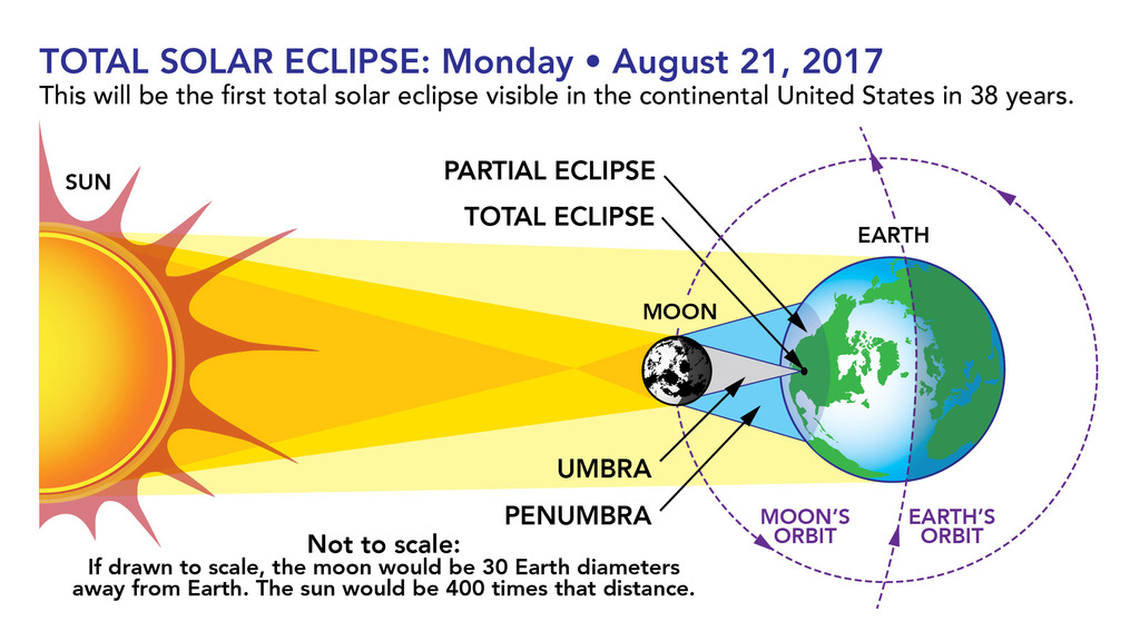
During the solar eclipse on August 21, 2017, the Moon's shadow will pass over all of North America. The path of the umbra, where the eclipse is total, stretches from Salem, Oregon to Charleston, South Carolina. This will be the first total solar eclipse visible in the contiguous United States in 38 years.
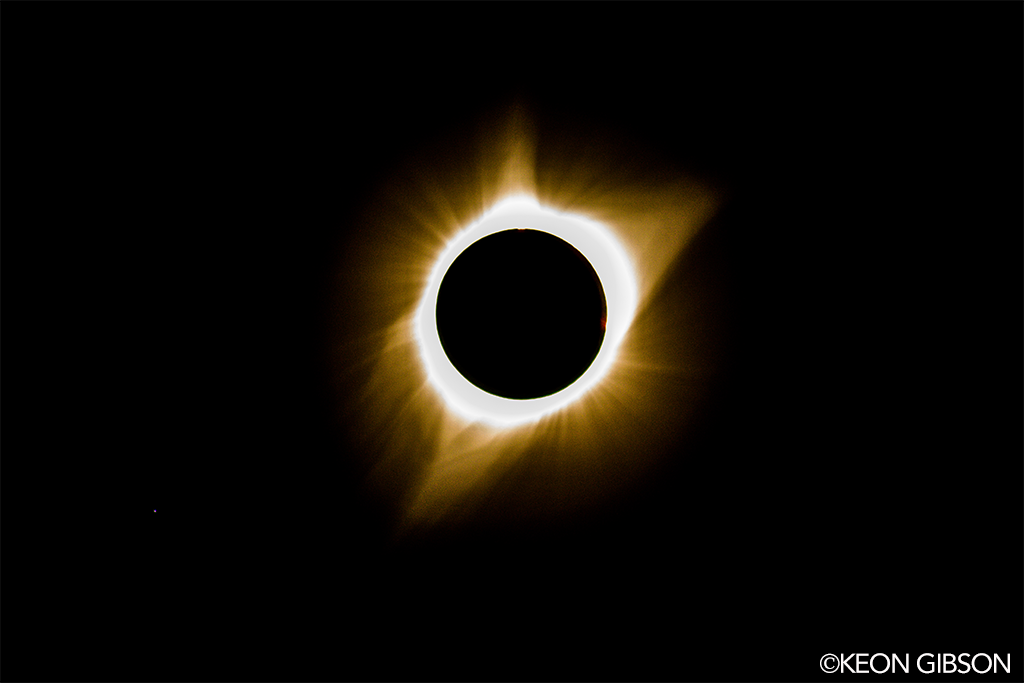
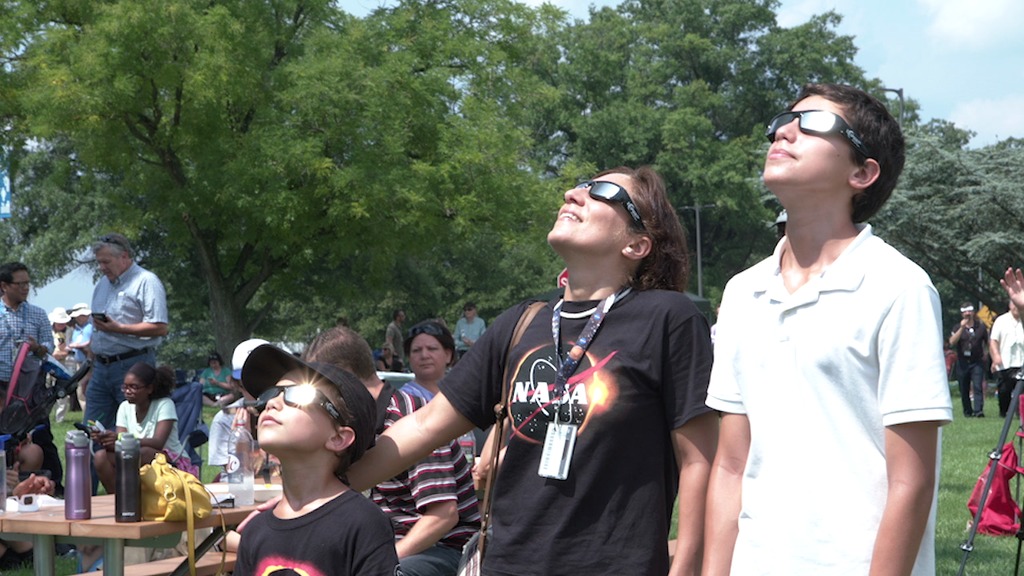
During those brief moments when the moon completely blocks the sun’s bright face for 2 + minutes, day will turn into night, making visible the otherwise hidden solar corona, the sun’s outer atmosphere. Bright stars and planets will become visible as well. This is truly one of nature’s most awesome sights.
The eclipse provides a unique opportunity to study the sun, Earth, moon and their interaction because of the eclipse’s long path over land coast to coast. Scientists will be able to take ground-based and airborne observations over a period of an hour and a half to complement the wealth of data provided by NASA assets.
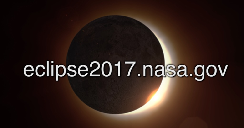
Visit https://eclipse2017.nasa.gov for more information.
Aug. 21 Total Solar Eclipse Imagery
- ID: 12690 Produced Video
An EPIC View of the 2017 Total Solar Eclipse
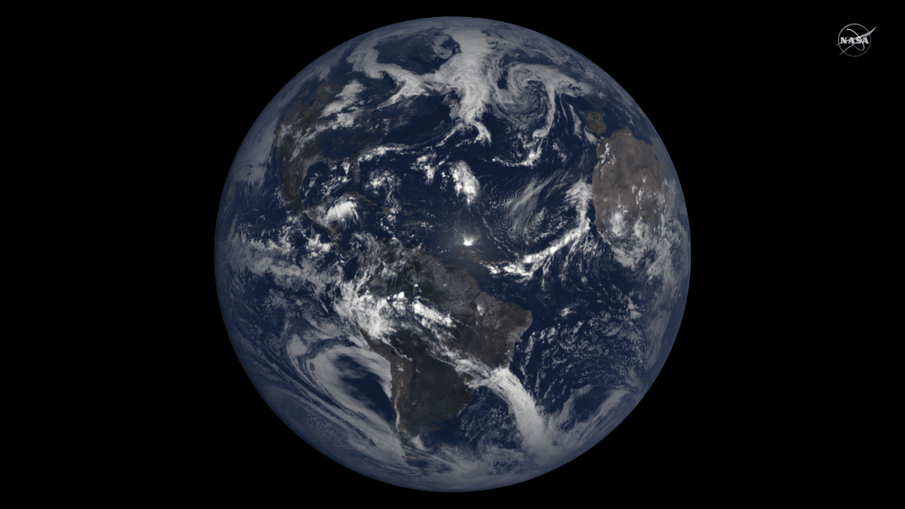
Go to this pageNASA's Earth Polychromatic Imaging Camera (EPIC) tracked the path of the total solar eclipse across North America on Aug. 21, 2017. On board NOAA's Deep Space Climate Observatory (DSCOVR), EPIC collected these natural color images. Scientists set the instrument to gather images more frequently than usual to study this eclipse.Learn more about how EPIC contributed to research conducted during the 2017 total solar eclipse. ||
- ID: 12688 Produced Video
SDO's View of the August 21 Solar Eclipse
Go to this pageA movie of the Aug 21, 2017 lunar transit as viewed by the Solar Dynamics Observatory (SDO.) The Sun appears in visible light, and 171 ångstrom extreme ultraviolet light. The movie shows the Sun moving a bit because SDO has a hard time keeping the Sun centered in the image during a transit, because the Moon blocks so much light. The fine guidance systems on the SDO instruments need to see the whole Sun in order keep the images centered from exposure to exposure. Once the transit was over, the fine guidance systems started back up, once again providing steady images of the Sun.Credit: NASA/SDOWatch this video on the NASA Goddard YouTube channel. || SDO_Eclipse_Transit_Still.jpg (3840x2160) [1.4 MB] || SDO_Eclipse_Transit_Still_searchweb.png (320x180) [70.6 KB] || SDO_Eclipse_Transit_Still_thm.png (80x40) [5.5 KB] || 12688_SDO_Eclipse_Transit_H264_1080.webm (1920x1080) [4.6 MB] || 12688_SDO_Eclipse_Transit_H264_1080.mov (1920x1080) [126.4 MB] || 12688_SDO_Eclipse_Transit_H264_best_3840x2160_2997.mov (3840x2160) [378.1 MB] || 12688_SDO_Eclipse_Transit_ProRes_3840x2160_2997.mov (3840x2160) [2.7 GB] ||
- ID: 12704 Produced Video
NASA Eclipse Imagery
Go to this pageAs millions of people across the United States experienced a total eclipse as the umbra, or Moon’s shadow passed over them, only six people witnessed the umbra from space. Viewing the eclipse from orbit were NASA’s Randy Bresnik, Jack Fischer and Peggy Whitson, ESA (European Space Agency’s) Paolo Nespoli, and Roscosmos’ Commander Fyodor Yurchikhin and Sergey Ryazanskiy. The space station crossed the path of the eclipse three times as it orbited above the continental United States at an altitude of 250 miles. Credit: NASA || iss052e056122.jpg (4928x3280) [844.0 KB] ||
- ID: 12677 Produced Video

Satellite Views Of The Eclipse
Go to this pageOn Monday, Aug. 21, all of North America was treated to one of the rarest celestial events – a solar eclipse. During the eclipse, 14 states across the U.S. were in the path of totality and experienced more than two minutes of darkness in the middle of the day – with a partial eclipse viewable all across North America. NASA had a number of satellites looking back at the Earth and at the sun during the eclipse and here's what they saw. The eclipse’s long path over land provided a unique opportunity to study the Sun, Earth, Moon and their interaction.Solar eclipses happen somewhere in the world about every 18 months, but much of the time it happens over the ocean. To have an eclipse travel across so much land where millions of people live is incredibly rare, and makes for a unique opportunity for so many to witness one of nature’s most impressive shows.Still images from Earth and science satellites will be uploaded/available at https://flic.kr/s/aHsm21Mytv.Images sent in by the general public will be uploaded/available at https://www.flickr.com/groups/nasa-eclipse2017/. ||
- ID: 12698 Produced Video
What Spacecraft Saw During the 2017 Solar Eclipse
Go to this pageOn Aug. 21, 2017, a solar eclipse passed over North America. People throughout the continent experienced a partial solar eclipse, and a total solar eclipse passed over a narrow swath of land stretching from Oregon to South Carolina, called the path of totality. NASA and its partner’s satellites had a unique vantage point to watch the eclipse. Several Sun-watching satellites were in a position to see the Moon cross in front of the Sun, while many Earth-observing satellites – and NASA’s Lunar Reconnaissance Orbiter, which typically images the Moon’s landscape – captured images of the Moon’s shadow on Earth’s surface. See more and download content at https://go.nasa.gov/2x7b8kf ||
- ID: 12678 B-Roll
Eclipse Watching B-Roll At NASA Goddard
Go to this pageB-roll for August 21st Eclipse, filmed at NASA'S Goddard Space Flight Center's mall and visitor center. || GSFC_ECLIPSE2017BROLL_TW@N_Handleman.06600_print.jpg (1024x576) [177.8 KB] || GSFC_ECLIPSE2017BROLL_TW@N_Handleman.06600_searchweb.png (320x180) [115.7 KB] || GSFC_ECLIPSE2017BROLL_TW@N_Handleman.06600_thm.png (80x40) [7.9 KB] || GSFC_ECLIPSE2017BROLL_TW@N_Handleman.webm (1280x720) [30.1 MB] || GSFC_ECLIPSE2017BROLL_TW@N_Handleman.mp4 (1280x720) [266.8 MB] || GSFC_ECLIPSE2017BROLL_TW@N_Handleman.mov (1280x720) [3.2 GB] ||
- ID: 12703 Produced Video

Eclipse Imagery Along Path of Totality
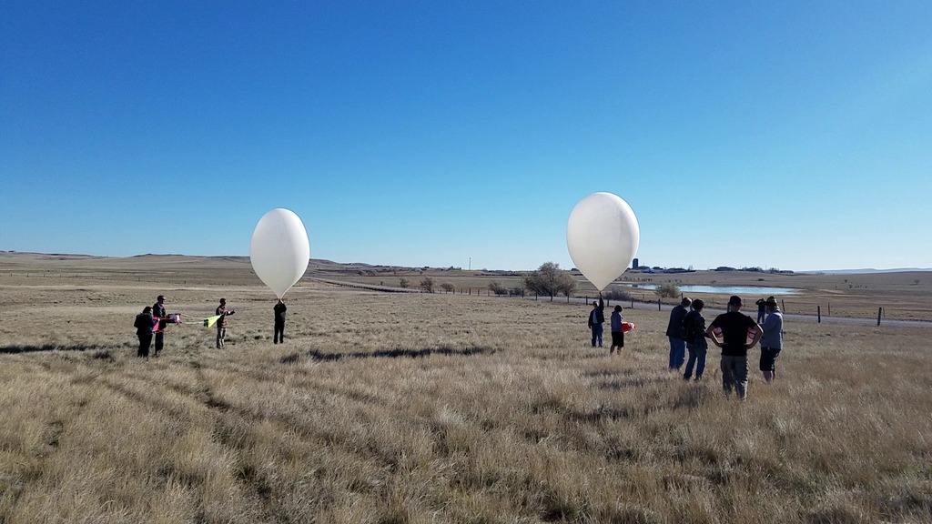
Go to this pageCarbondale, IL - The Eclipse Ballooning Project inflating high altitude balloons in Saluki Stadium during the Aug. 21, 2017, total solar eclipse. Credit: NASA/Joy Ng || Balloons2_JoyNg_print.jpg (1024x682) [877.1 KB] || Balloons2_JoyNg.jpg (5760x3840) [9.8 MB] || Balloons_JoyNg.jpg (5760x3840) [13.4 MB] || Balloons2_JoyNg_searchweb.png (320x180) [122.4 KB] || Balloons2_JoyNg_web.png (320x213) [144.1 KB] || Balloons2_JoyNg_thm.png (80x40) [8.2 KB] ||
- ID: 12715 Produced Video

Baseball Hits an Eclipse
Go to this pageOne of the best places to view the 2017 Total Solar Eclipse was at a ballpark in Keizer, Oregon. Here, NASA Goddard and the Lunar Reconnaissance Orbiter mission partnered with the Salem-Keizer Volcanoes Minor League Baseball team for an "EclipseFest" that featured the first ever "Eclipse Delay" in baseball history. This video shows what took place at the event.Music provided by KillerTracks: "Dayz On The Road" - Billy Lincoln, Thomas Dean Pugh-Fields; "Take Me Out to the Ball Game" - Harry Edwards; "The World Is Wide Enough" - Roger Rodes SendrosWatch this video on the NASA.gov Video YouTube channel. || Volcanoes2Thumnail.jpg (1920x1080) [854.8 KB] || Volcanoes2Thumnail_searchweb.png (320x180) [142.0 KB] || Volcanoes2Thumnail_thm.png (80x40) [9.0 KB] || Baseball-Hits-An-Eclipse-YouTubeHD.mp4 (1920x1080) [420.1 MB] || Baseball-Hits-An-Eclipse-Facebook.mp4 (1280x720) [320.0 MB] || Baseball-Hits-An-Eclipse-MASTER.mov (1920x1080) [3.4 GB] || Baseball-Hits-An-Eclipse-Facebook.webm (1280x720) [31.0 MB] || Baseball-Hits-An-Eclipse-Captions.en_US.srt [4.7 KB] || Baseball-Hits-An-Eclipse-Captions.en_US.vtt [4.7 KB] ||
- ID: 30893 Hyperwall Visual
2017 Eclipse Image Collection
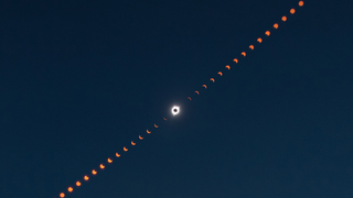
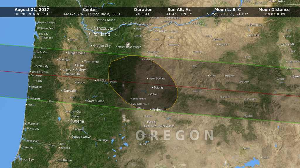
Go to this pageThis image is a composite photograph that shows the progression of the total solar eclipse over Madras, Oregon.http://earthobservatory.nasa.gov/NaturalHazards/view.php?id=90796 || eclipsecomposite_pho_lrg.jpg (2231x1487) [541.4 KB] || eclipsecomposite_pho_lrg_searchweb.png (320x180) [47.2 KB] || eclipsecomposite_pho_lrg_thm.png (80x40) [3.3 KB] || 2017-eclipse-images-7.hwshow [293 bytes] ||
What is an Eclipse?
- ID: 12551 Produced Video

Get Ready for the 2017 Solar Eclipse
Go to this pageMusic credit: Ascending Lanterns by Philip HochstrateWatch this video on the NASA Goddard YouTube channel.Complete transcript available. || promothumb.jpg (1920x1080) [115.5 KB] || promothumb_print.jpg (1024x576) [101.0 KB] || promothumb_searchweb.png (320x180) [79.9 KB] || promothumb_web.png (320x180) [79.9 KB] || promothumb_thm.png (80x40) [6.7 KB] || 12551_Eclipse_Promo_V3.540.AppleTV.H264.2997.mp4 (960x540) [16.7 MB] || 12551_Eclipse_Promo_V3.1080p.H264.2997.webm (1920x1080) [13.7 MB] || 12551_Eclipse_Promo_V3.1080p.H264.2997.mp4 (1920x1080) [336.1 MB] || 12551_Eclipse_Promo_2017_V2.en_US.srt [1.7 KB] || 12551_Eclipse_Promo_2017_V2.en_US.vtt [1.7 KB] || 12551_Eclipse_Promo_V3.4KAPR2997.webm (3840x2160) [14.9 MB] || 12551_Eclipse_Promo_V3.4K.H264.2997.mp4 (3840x2160) [122.0 MB] || 12551_Eclipse_Promo_V3.1080.APR5994.mov (1920x1080) [3.1 GB] || 12551_Eclipse_Promo_V3.4KAPR2997.mov (3840x2160) [6.1 GB] ||
- ID: 12534 Produced Video
What determines when we have an eclipse?
Go to this pageMusic: Witch Waltz by Dorian KellyComplete transcript available.Watch this video on the NASA Goddard YouTube channel. || EclipsePlane_V7.00001_print.jpg (1024x576) [79.6 KB] || EclipsePlane_V7.00001_searchweb.png (320x180) [62.0 KB] || EclipsePlane_V7.00001_thm.png (80x40) [3.8 KB] || EclipsePlane_V7.mp4 (1920x1080) [63.0 MB] || EclipsePlane_V7_1.mp4 (1920x1080) [91.4 MB] || EclipsePlane_V7.webm (1920x1080) [5.7 MB] || EclipsePlane_V7.en_US.srt [499 bytes] || EclipsePlane_V7.en_US.vtt [511 bytes] || EclipsePlane_V7.mov (1920x1080) [1.6 GB] ||
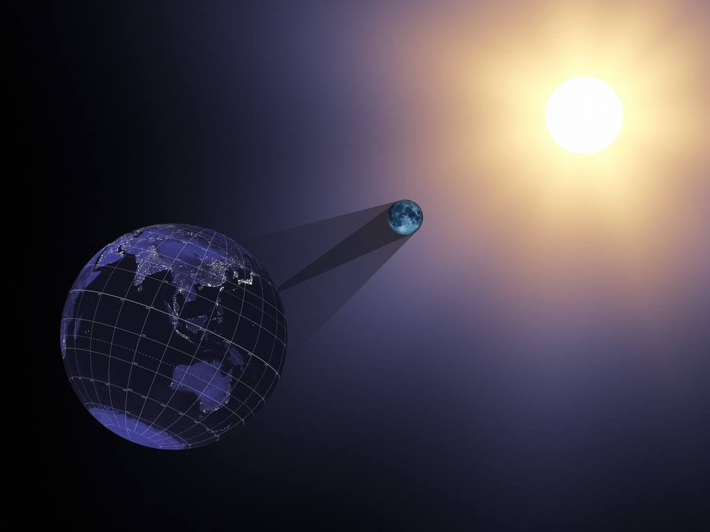
- ID: 4324 Visualization
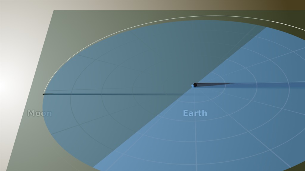
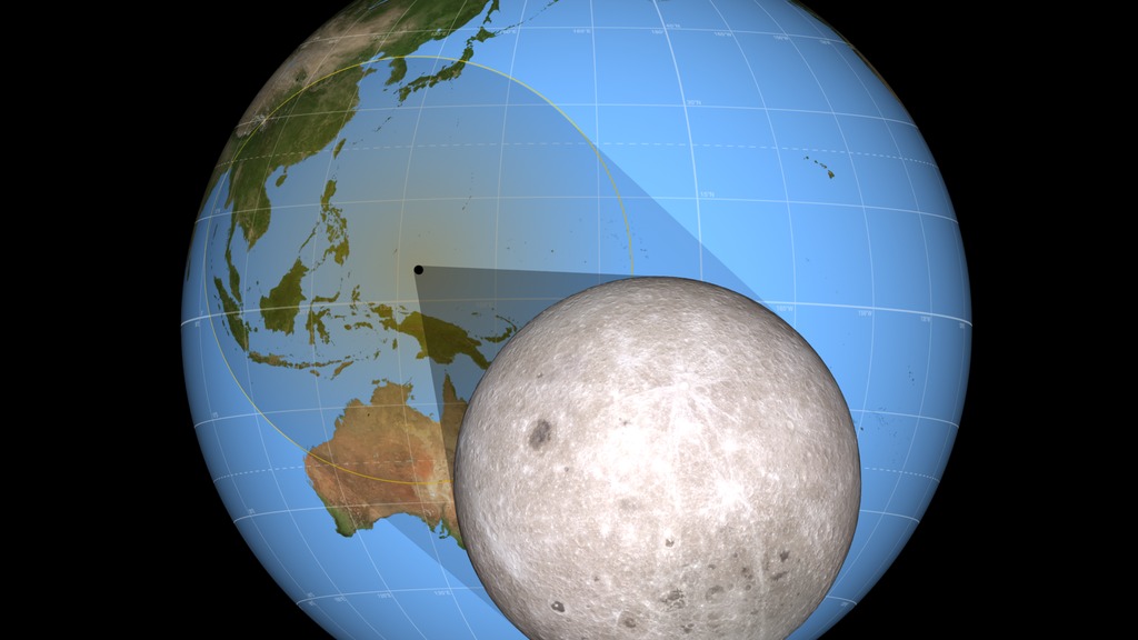
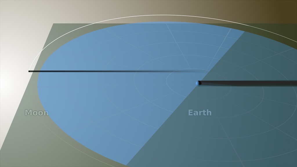
2017 Eclipse and the Moon's Orbit
Go to this pageThe Moon orbits the Earth in the months prior to the August 21, 2017 total solar eclipse. Viewed from above, the Moon's shadow appears to cross the Earth every month, but a side view reveals the five-degree tilt of the Moon's orbit. Its shadow only hits the Earth when the line of nodes, the fulcrum of its orbital tilt, is pointed toward the Sun. || orbit.0350_print.jpg (1024x576) [37.8 KB] || orbit.0350_searchweb.png (320x180) [37.6 KB] || orbit.0350_thm.png (80x40) [4.1 KB] || eclipse_orbit_720p30.webm (1280x720) [3.3 MB] || eclipse_orbit_1080p30.mp4 (1920x1080) [3.6 MB] || eclipse_orbit_720p30.mp4 (1280x720) [1.8 MB] || orbit (1920x1080) [0 Item(s)] || eclipse_orbit_1080p30.mov (1920x1080) [391.1 MB] || eclipse_orbit_360p30.mp4 (640x360) [662.1 KB] || 2017-eclipse-moon-orbit.hwshow [287 bytes] ||
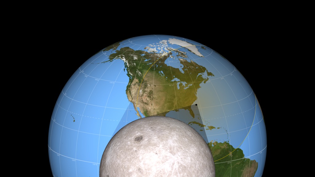
- ID: 4390 Visualization
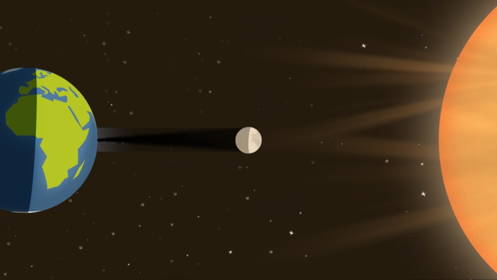
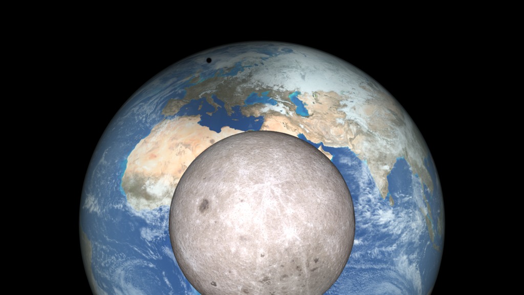
2017 Eclipse: Earth, Moon and Sun
Go to this pageThe Moon moves right to left in its orbit around the Earth. The shadow it casts hits the Earth during the August 21, 2017 total solar eclipse. || sun_earth.0240_print.jpg (1024x576) [41.2 KB] || sun_earth.0240_searchweb.png (320x180) [37.9 KB] || sun_earth.0240_thm.png (80x40) [3.9 KB] || eclipse2017sunearth_1080p30.mp4 (1920x1080) [3.6 MB] || eclipse2017sunearth_720p30.mp4 (1280x720) [1.6 MB] || 1920x1080_16x9_30p (1920x1080) [0 Item(s)] || eclipse2017sunearth_720p30.webm (1280x720) [2.7 MB] || eclipse2017sunearth_360p30.mp4 (640x360) [514.7 KB] || eclipse2017sunearth_1080p30.mp4.hwshow [193 bytes] ||
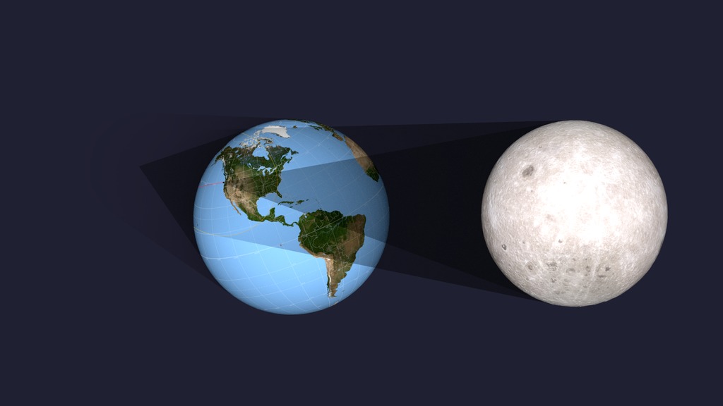
- ID: 4321 Visualization
2017 Eclipse Shadow Cones
Go to this pageThe umbral and penumbral shadow cones travel across the surface of the Earth during the August 21, 2017 total solar eclipse. || cones.0885_print.jpg (1024x576) [79.2 KB] || cones.0885_searchweb.png (320x180) [46.7 KB] || cones.0885_thm.png (80x40) [4.1 KB] || shadow_cones_1080p30.mp4 (1920x1080) [13.9 MB] || shadow_cones_720p30.mp4 (1280x720) [6.9 MB] || shadow_cones_720p30.webm (1280x720) [5.6 MB] || shadow_cones_720p30.wmv (1280x720) [17.9 MB] || 1920x1080_16x9_30p (1920x1080) [0 Item(s)] || shadow_cones_360p30.mp4 (640x360) [2.3 MB] || 2017-eclipse-shadow-cones-mp4.hwshow [217 bytes] ||
- ID: 4579 Visualization
Flying Around The Eclipse Shadow
Go to this pageA view of the Moon's shadow during the August 21, 2017 eclipse from both the night and day sides of the Earth. || night_to_day.0300_print.jpg (1024x576) [47.6 KB] || night_to_day.0300_searchweb.png (320x180) [28.2 KB] || night_to_day.0300_thm.png (80x40) [3.2 KB] || eclipse_flyaround_1080p30.mp4 (1920x1080) [36.2 MB] || eclipse_flyaround_720p30.mp4 (1280x720) [12.7 MB] || 1920x1080_16x9_30p (1920x1080) [0 Item(s)] || eclipse_flyaround_720p30.webm (1280x720) [5.4 MB] || eclipse_flyaround_720p30.wmv (1280x720) [42.8 MB] || FlyingAroundTheEclipseShadow.mov (1280x720) [682.8 MB] || eclipse_flyaround_360p30.mp4 (640x360) [4.3 MB] || 3840x2160_16x9_30p (3840x2160) [0 Item(s)] || eclipse_flyaround_2160p30.mp4 (3840x2160) [122.4 MB] || FlyingAroundTheEclipseShadow4k.mov (3840x2160) [2.4 GB] || eclipse_flyaround_1080p30.mp4.hwshow [222 bytes] ||
- ID: 12674 Produced Video
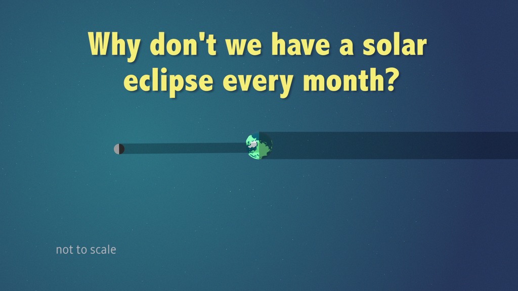
Eclipse Background
Go to this pageEclipses, whether solar or lunar, occur because of the periodic alignments of the sun, Earth, and moon. These three bodies, orbit in space in very predictable paths (yes, the sun orbits too. It orbits the galaxy once every 200 million years!). Ever since the days of Kepler and Newton, we have been able to predict the motion of planetary bodies with great precision. So, why do eclipses happen?Solar eclipses happen when the moon moves between Earth and the sun. You might think that this should happen every month since the moon’s orbit, depending on how it is defined is between about 27 and 29 days long. But our moon’s orbit is tilted with respect to Earth’s orbit around the sun by about five degrees. Not much, you say? Yes, but the moon, itself, is only about ½ degree in width in the sky, about ½ the width of your pinky finger held at arm’s length. So, sometimes the moon misses too high and sometimes too low to cause a solar eclipse. Only when the sun, moon, and Earth line up close to the “line of nodes”, the imaginary line that represents the intersection of the orbital planes of the moon and Earth, can you have an eclipse.This is true for both solar and lunar eclipses. This situation is somewhat unique as no other moon in the solar system orbits roughly in the plane of the “ecliptic”, Earth’s orbital plane, that the planets more or less follow. ||
- ID: 12648 Produced Video
The Moon's Role in a Solar Eclipse
Go to this pageThis video explains how our moon creates a solar eclipse, why it's such a rare event to see, and how data from NASA's Lunar Reconnaissance Orbiter has enhanced our ability to map an eclipse's path of totality.Music Provided by Universal Production Music: “Bring Me Up” – Anders Gunnar Kampe & Henrik Lars Wikstrom.Watch this video on the NASA.gov Video YouTube channel. || MoonsRoleEclipseThumnail_print.jpg (1024x576) [40.9 KB] || LROSolarEclipse_Thumbnail.jpg (1080x1920) [491.4 KB] || MoonsRoleEclipseThumnail_searchweb.png (320x180) [34.1 KB] || MoonsRoleEclipseThumnail_thm.png (80x40) [4.4 KB] || 12648_MoonsRoleInASolarEclipse_Facebook.webm (1280x720) [21.0 MB] || MoonsRoleEclipseThumnail.tif (1920x1080) [7.9 MB] || 12648_MoonsRoleInASolarEclipse_Facebook.mp4 (1280x720) [219.1 MB] || 12648_MoonsRoleInASolarEclipse_YOUTUBE_1080.mp4 (1920x1080) [296.7 MB] || 12648_MoonsRoleInASolarEclipse_Captions.en_US.srt [3.7 KB] || 12648_MoonsRoleInASolarEclipse_Captions.en_US.vtt [3.7 KB] || 12648_MoonsRoleInASolarEclipse_MASTER.mov (1920x1080) [4.1 GB] ||
2017 Eclipse Path
- ID: 12412 Produced Video
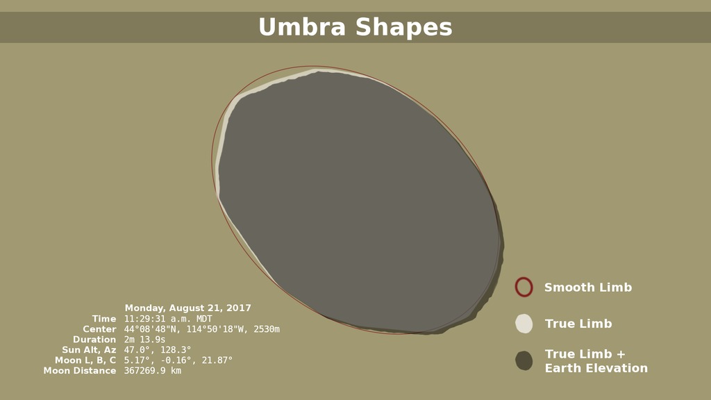
Tracing the 2017 Solar Eclipse
Go to this pageWhen depicting an eclipse path, data visualizers have usually chosen to represent the moon's shadow as an oval. By bringing in a variety of NASA data sets, visualizer Ernie Wright has created a new and more accurate representation of the eclipse. For the first time, we are able to see that the moon's shadow is better represented as a polygon. This more complicated shape is based NASA's Lunar Reconnaissance Orbiter's view of the mountains and valleys that form the moon's jagged edge. By combining moon's terrain, heights of land forms on Earth, and the angle of the sun, Wright is able to show the eclipse path with the greatest accuracy to date. ||
- ID: 4518 Visualization
2017 Total Solar Eclipse Map and Shapefiles
Go to this pageA map of the United States showing the path of totality for the August 21, 2017 total solar eclipse. This is version 2 of the map, available at both 5400 × 2700 and 10,800 × 5400. || usa_eclipse_map_v2_print.jpg (1024x512) [192.9 KB] || usa_eclipse_map_v2.tif (5400x2700) [26.7 MB] || usa_eclipse_map_v2x2.tif (10800x5400) [85.4 MB] ||
- ID: 4314 Visualization
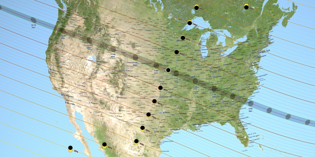
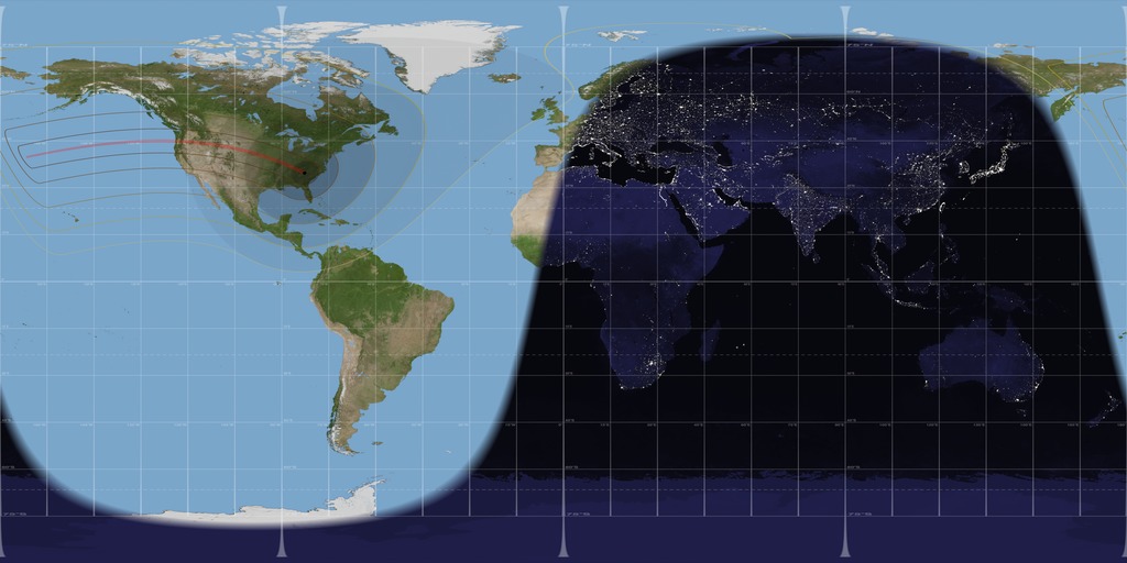
2017 Total Solar Eclipse in the U.S.
Go to this pageA view of the United States during the total solar eclipse of August 21, 2017, showing the umbra (black oval), penumbra (concentric shaded ovals), and path of totality (red) through or very near several major cities. || usa.0780_print.jpg (1024x576) [144.7 KB] || usa.0780_searchweb.png (320x180) [90.1 KB] || usa.0780_thm.png (80x40) [6.8 KB] || eclipse2017usa_1080p30.mp4 (1920x1080) [26.0 MB] || eclipse2017usa_720p30.mp4 (1280x720) [14.0 MB] || eclipse2017usa_720p30.webm (1280x720) [5.0 MB] || fancy (1920x1080) [0 Item(s)] || eclipse2017usa_2160p30.mp4 (3840x2160) [69.5 MB] || eclipse2017usa_360p30.mp4 (640x360) [5.1 MB] || fancy (3840x2160) [0 Item(s)] || 9600x3240_3x1_30p (9600x3240) [0 Item(s)] || 2017_US_eclipse_4314.pptx [14.6 MB] || 2017_US_eclipse_4314.key [17.1 MB] ||
- ID: 4515 Visualization
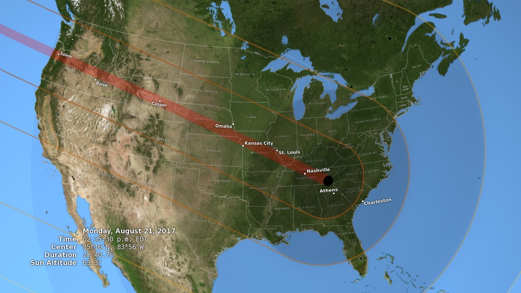
2017 Path of Totality
Go to this pageThis visualization closely follows the Moon's umbra shadow as it passes over the United States during the August 21, 2017 total solar eclipse. It covers the one hour and 40 minutes between 10:12 am PDT and 2:52 pm EDT. Through the use of a number of NASA datasets, notably the global elevation maps from Lunar Reconnaissance Orbiter, the shape and location of the shadow is depicted with unprecedented accuracy. || usa.0500_print.jpg (1024x576) [257.5 KB] || usa.0500_searchweb.png (320x180) [108.8 KB] || usa.0500_thm.png (80x40) [7.1 KB] || usa (1280x720) [0 Item(s)] || totpath2017_720p30.webm (1280x720) [22.3 MB] || totpath2017_1080p30.mp4 (1920x1080) [190.1 MB] || totpath2017_720p30.mp4 (1280x720) [123.2 MB] || totpath2017_360p30.mp4 (640x360) [40.4 MB] || 3840x2160_16x9_30p (3840x2160) [0 Item(s)] || totpath2017_4515.key [125.2 MB] || totpath2017_4515.pptx [124.7 MB] || totpath2017_2160p30.mp4 (3840x2160) [407.4 MB] ||
- ID: 4552 Visualization
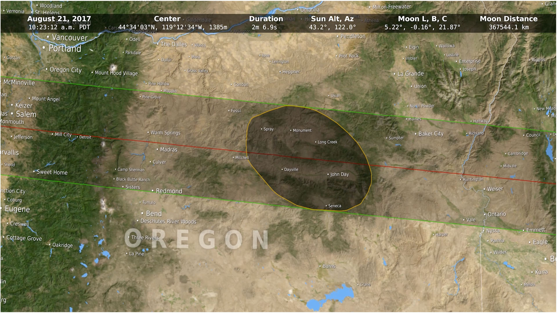
2017 Eclipse State Maps
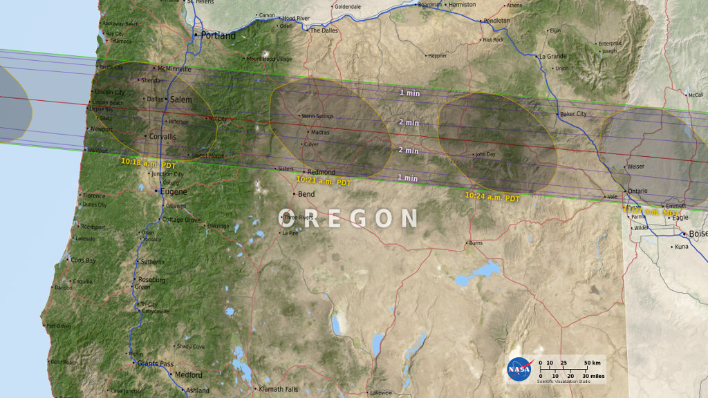
Go to this pageThe path of totality passes through 14 states during the total solar eclipse on August 21, 2017. A map of each of these states, created for NASA's official eclipse 2017 website, is presented here. Except for Montana, each map is 8 inches wide (or high) at 300 DPI. The umbra is shown at 3-minute intervals, with times in the local time zone at the umbra center. The duration of totality is outlined in 30-second increments. Interstate highways are blue, other major roads are red, and secondary roads are gray.Some sources list only 12 states for this eclipse, but in fact the path of totality also grazes the southwestern borders of both Montana and Iowa. The Montana part of the path is in a roadless area at the southern end of the Beaverhead Mountains, a range that defines sections of both the Montana-Idaho border and the Continental Divide. The Iowa part of the path is west of Interstate 29 near Hamburg, south of 310 Street, and bounded on the west by the Missouri River. It includes the Lower Hamburg Bend Wildlife Management Area. ||
Eclipse Safety
- ID: 12517 Produced Video

Watching the Friendly Skies - Eclipse Safety Tutorial
Go to this pageMusic Credit: Chic to Chic by Piero PiccioniWatch this video on the NASA Goddard YouTube channel.Complete transcript available. || safetyThumbnail.jpg (1920x1080) [115.2 KB] || safetyThumbnail_searchweb.png (320x180) [92.4 KB] || safetyThumbnail_thm.png (80x40) [7.7 KB] || 12517_eclipse_safety_wpost.webm (1920x1080) [24.0 MB] || TWITTER_720-12517_eclipse_safety_wpost_VX-691382_twitter_720.mp4 (1280x720) [45.5 MB] || 12517_eclipse_safety_wpost.mp4 (1920x1080) [211.6 MB] || FACEBOOK_720-12517_eclipse_safety_wpost_VX-691382_facebook_720.mp4 (1280x720) [259.9 MB] || YOUTUBE_1080-12517_eclipse_safety_wpost_VX-691382_youtube_1080.mp4 (1920x1080) [346.3 MB] || YOUTUBE_720-12517_eclipse_safety_wpost_VX-691382_youtube_720.mp4 (1280x720) [347.9 MB] || 12517_eclipse_safety_wpost.en_US.srt [3.8 KB] || 12517_eclipse_safety_wpost.en_US.vtt [3.8 KB] || 12517_eclipse_safety_wpost_VX-691382_lowres.mp4 (480x272) [28.3 MB] || NASA_PODCAST-12517_eclipse_safety_wpost_VX-691382_ipod_sm.mp4 (320x240) [40.1 MB] || 12517_eclipse_safety_wpost.mov (1920x1080) [5.1 GB] ||
- ID: 12638 Produced Video

How to View the Solar Eclipse with a Pinhole Projector
Go to this pageMusic credit: Apple of My Eye by Frederik WiedmannWatch this video on the NASA Goddard YouTube channel.Complete transcript available. || 12638_How_to_Make_a_Pinhole_ProjectorV3_QT.H264.2997.00039_print.jpg (1024x576) [65.1 KB] || 12638_How_to_Make_a_Pinhole_ProjectorV3_QT.H264.2997.00039_searchweb.png (320x180) [45.1 KB] || 12638_How_to_Make_a_Pinhole_ProjectorV3_QT.H264.2997.00039_thm.png (80x40) [5.3 KB] || 12638_How_to_Make_a_Pinhole_ProjectorV3_QT.H264.2997.mov (1920x1080) [40.8 MB] || 12638_How_to_Make_Pinhole_ProjectorV3_AppleTV540.mp4 (960x540) [10.9 MB] || 12638_How_to_Make_Pinhole_ProjectorV3_H264.2997.mp4 (1920x1080) [77.4 MB] || 12638_How_to_Make_a_Pinhole_ProjectorV3_QT.H264.2997.webm (1920x1080) [8.9 MB] || 12638_How_to_Make_Pinhole_ProjectorV3_YouTube1080p.mp4 (1920x1080) [116.4 MB] || 12638_How_to_Make_a_Pinhole_Projector.en_US.srt [1.0 KB] || 12638_How_to_Make_a_Pinhole_Projector.en_US.vtt [1.0 KB] || 12638_How_to_Make_Pinhole_ProjectorV3_APR5994.mov (1920x1080) [2.1 GB] ||
- ID: 12637 Produced Video
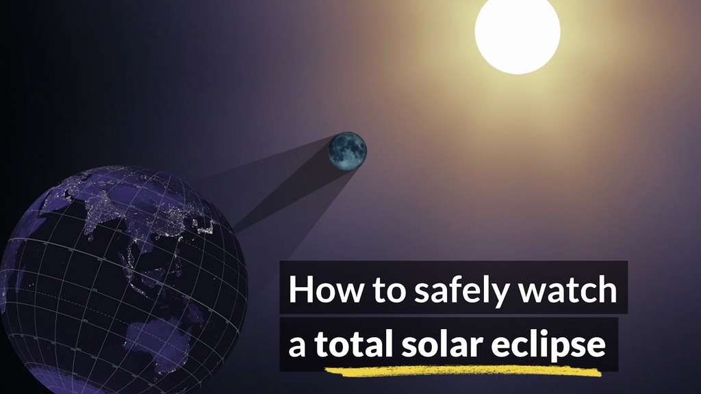
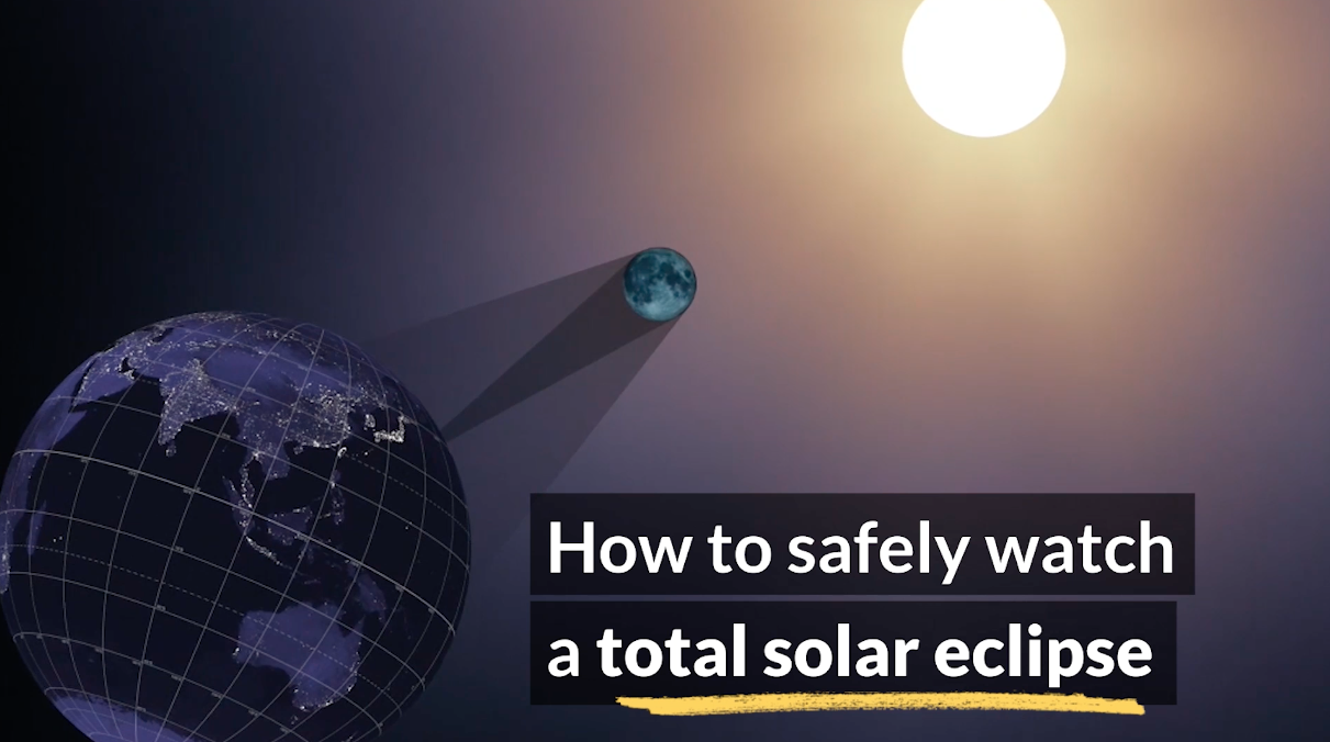
How to Safely Watch a Solar Eclipse
Go to this pageIt is never safe to look directly at the sun's rays – even if the sun is partly obscured. When watching a partial eclipse you must wear eclipse glasses at all times if you want to face the sun, or use an alternate indirect method. This also applies during a total eclipse up until the time when the sun is completely and totally blocked.During the short time when the moon completely obscures the sun – known as the period of totality – it is safe to look directly at the star, but it's crucial that you know when to take off and put back on your glasses.First and foremost: Check for local information on timing of when the total eclipse will begin and end. NASA's page of eclipse times is a good place to start. Second: The sun also provides important clues for when totality is about to start and end.Learn more at https://eclipse2017.nasa.govFind more videos about the solar ecilpse on the Sun Eclipse 2017 gallery page. ||
- ID: 12551 Produced Video
Get Ready for the 2017 Solar Eclipse
Go to this pageMusic credit: Ascending Lanterns by Philip HochstrateWatch this video on the NASA Goddard YouTube channel.Complete transcript available. || promothumb.jpg (1920x1080) [115.5 KB] || promothumb_print.jpg (1024x576) [101.0 KB] || promothumb_searchweb.png (320x180) [79.9 KB] || promothumb_web.png (320x180) [79.9 KB] || promothumb_thm.png (80x40) [6.7 KB] || 12551_Eclipse_Promo_V3.540.AppleTV.H264.2997.mp4 (960x540) [16.7 MB] || 12551_Eclipse_Promo_V3.1080p.H264.2997.webm (1920x1080) [13.7 MB] || 12551_Eclipse_Promo_V3.1080p.H264.2997.mp4 (1920x1080) [336.1 MB] || 12551_Eclipse_Promo_2017_V2.en_US.srt [1.7 KB] || 12551_Eclipse_Promo_2017_V2.en_US.vtt [1.7 KB] || 12551_Eclipse_Promo_V3.4KAPR2997.webm (3840x2160) [14.9 MB] || 12551_Eclipse_Promo_V3.4K.H264.2997.mp4 (3840x2160) [122.0 MB] || 12551_Eclipse_Promo_V3.1080.APR5994.mov (1920x1080) [3.1 GB] || 12551_Eclipse_Promo_V3.4KAPR2997.mov (3840x2160) [6.1 GB] ||
- ID: 12200 Produced Video
Solar Eclipse Safety Images
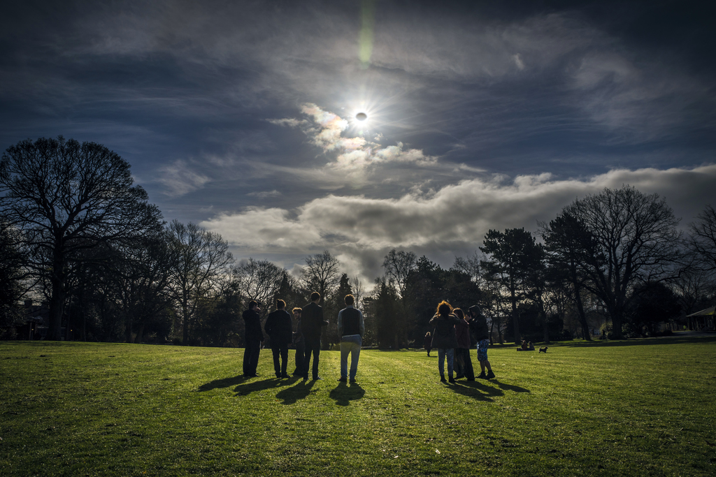
Go to this pagePeople watch a partial eclipse in Belfast, Northern Ireland, on Mar. 20, 2015. Credit: Robin Cordiner || RobinCordiner.jpg (926x618) [118.5 KB] || RobinCordinerlg_print.jpg (1024x683) [681.3 KB] || RobinCordinerlg.jpg (7065x4715) [22.0 MB] || RobinCordinerlg_searchweb.png (320x180) [98.8 KB] || RobinCordinerlg_web.png (320x213) [114.5 KB] || RobinCordinerlg_thm.png (80x40) [6.7 KB] ||
Eclipse Science
- ID: 12669 Produced Video
![Music: Dawn Drone by Juan Jose Alba Gomez [SGAE]Complete transcript available.](/vis/a010000/a012600/a012669/LARGE_MP4-EPICEclipse_Rescript_large.00696_print.jpg)
A New View of August's Total Solar Eclipse
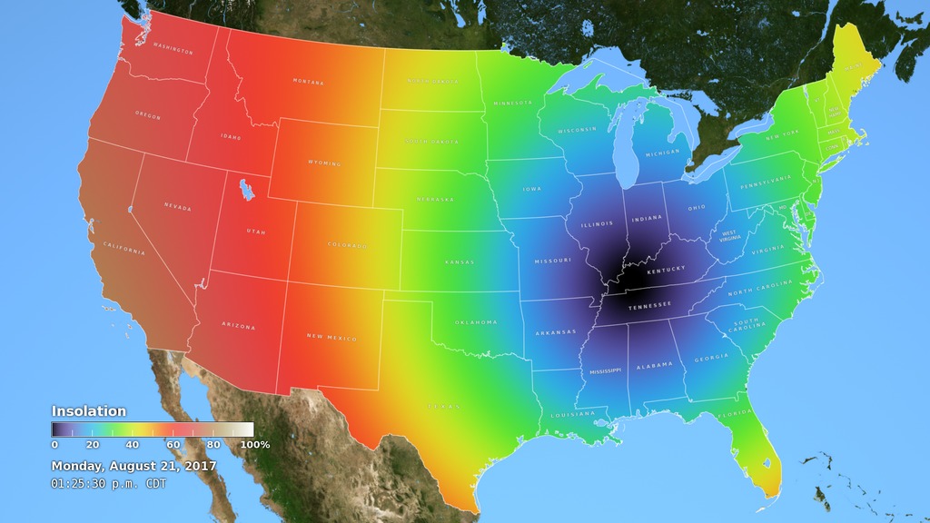
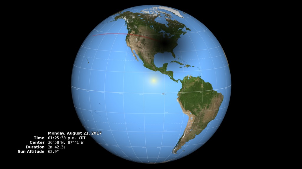
Go to this pageDuring the August 2017 total solar eclipse, scientists will use the Earth Polychromatic Imaging Camera (EPIC) on the Deep Space Climate Observatory (DSCOVR) satellite, along with measurements taken from within the moon's shadow on the ground, to test a new model of Earth's energy budget. ||
- ID: 12179 Produced Video

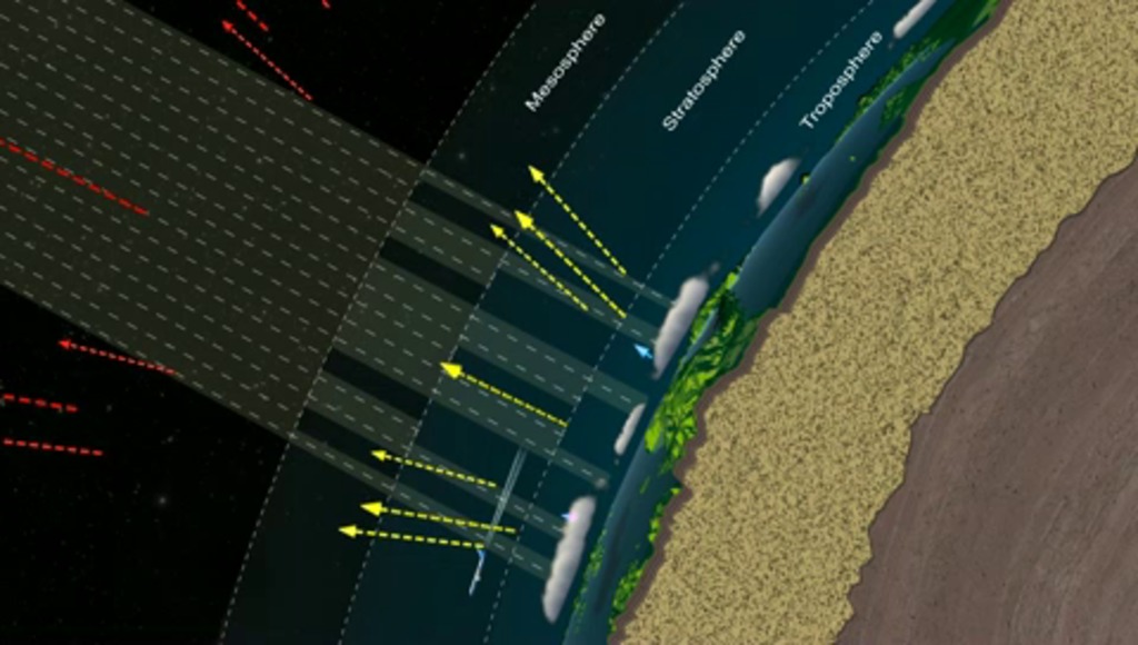
NASA Jets Chase The Total Solar Eclipse
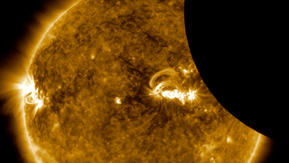
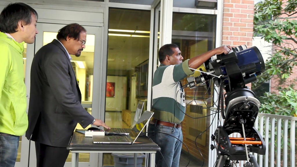
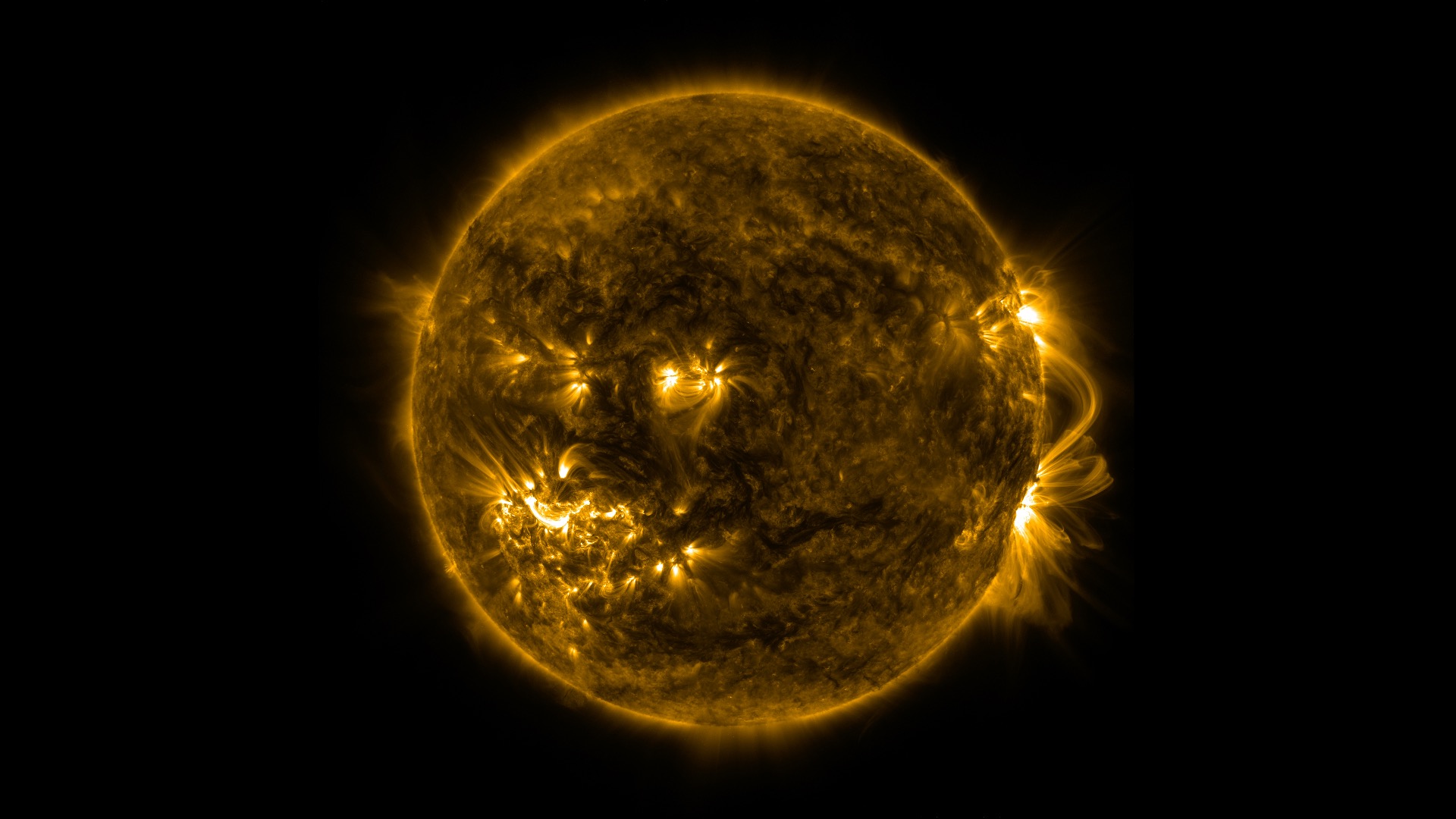
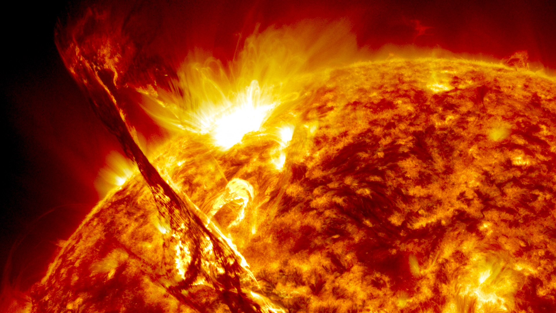
Go to this pageFor most viewers, the Aug. 21, 2017, total solar eclipse will last less than two and half minutes. But for one team of NASA-funded scientists, the eclipse will last over seven minutes. Their secret? Following the shadow of the Moon in two retrofitted WB-57F jet planes. Amir Caspi of the Southwest Research Institute in Boulder, Colorado, and his team will use two of NASA’s WB-57F research jets to chase the darkness across America on Aug. 21. Taking observations from twin telescopes mounted on the noses of the planes, Caspi will capture the clearest images of the Sun’s outer atmosphere — the corona — to date and the first-ever thermal images of Mercury, revealing how temperature varies across the planet’s surface. ||
- ID: 11937 Produced Video
Earth's Energy Budget
Go to this pageEarth's energy budget is a metaphor for the delicate equilibrium between energy received from the Sun versus energy radiated back out in to space. Research into precise details of Earth's energy budget is vital for understanding how the planet's climate may be changing, as well as variabilities in solar energy output. NASA’s (The Clouds and the Earth's Radiant Energy System) CERES and NASA's Total and Spectral solar Irradiance Sensor (TSIS-1), missions play key roles in our continued understanding of Earth’s Energy Budget.NASA’s TSIS helps scientists keep a close watch on the sun’s energy input to Earth. Various satellites have captured a continuous record of this solar energy input since 1978. TSIS-1 sensors advance previous measurements, enabling scientists to study the sun's natural influence on Earth's ozone layer, atmospheric circulation, clouds, and ecosystems. These observations are essential for a scientific understanding of the effects of solar variability on the Earth system. TSIS-1 makes two key measurements: total solar irradiance, or TSI, the sun's total energy input into Earth, and solar spectral irradiance (SSI), the distribution of the sun's energy input across ultraviolet, visible, and infrared wavelengths of light. TSI measurements are needed to quantify the solar variations in the total amount of energy input to the Earth. SSI measurements are also vital because different wavelengths of light are absorbed by different parts of the atmosphere.For more than 20 years, NASA Langley's CERES (System) instruments have measured the solar energy reflected by Earth, the heat the planet emits, and the role of clouds in that process. The final CERES Flight Model, CERES FM6 launched aboard NOAA’s JPSS-1 in Fall 2017. CERES FM6 contributes to an already extensive CERES dataset that helps scientists validate models that calculate the effect of clouds on planetary heating and cooling. The same data can also be helpful for improving near-term, seasonal forecasts influenced by weather events such as El Niño and La Niña. El Niño and La Niña are weather patterns that develop when ocean temperatures fluctuate between warm and cool phases in the Equatorial Pacific Ocean. Built by Northrop Grumman and managed by Langley, CERES FM6 joins five other CERES instruments orbiting the planet on three other satellites.NASA Goddard Space Flight Center manages the TSIS-1 project. The University of Colorado's Laboratory for Atmospheric and Space Physics (LASP) built both instruments and provides mission operations. The International Space Station carries TSIS-1.Earth's energy budget is a metaphor for the delicate equilibrium between energy received from the Sun versus energy radiated back out in to space. Research into precise details of Earth's energy budget is vital for understanding how the planet's climate may be changing, as well as variabilities in solar energy output. NASA’s (The Clouds and the Earth's Radiant Energy System) CERES and NASA's Total and Spectral solar Irradiance Sensor (TSIS-1), missions play key roles in our continued understanding of Earth’s Energy Budget.NASA’s TSIS helps scientists keep a close watch on the sun’s energy input to Earth. Various satellites have captured a continuous record of this solar energy input since 1978. TSIS-1 sensors advance previous measurements, enabling scientists to study the sun's natural influence on Earth's ozone layer, atmospheric circulation, clouds, and ecosystems. These observations are essential for a scientific understanding of the effects of solar variability on the Earth system. TSIS-1 makes two key measurements: total solar irradiance, or TSI, the sun's total energy input into Earth, and solar spectral irradiance (SSI), the distribution of the sun's energy input across ultraviolet, visible, and infrared wavelengths of light. TSI measurements are needed to quantify the solar variations in the total amount of energy input to the Earth. SSI measurements are also vital because different wavelengths of light are absorbed by different parts of the atmosphere.For more than 20 years, NASA Langley's CERES (System) instruments have measured the solar energy reflected by Earth, the heat the planet emits, and the role of clouds in that process. The final CERES Flight Model, CERES FM6 launched aboard NOAA’s JPSS-1 in Fall 2017. CERES FM6 contributes to an already extensive CERES dataset that helps scientists validate models that calculate the effect of clouds on planetary heating and cooling. The same data can also be helpful for improving near-term, seasonal forecasts influenced by weather events such as El Niño and La Niña. El Niño and La Niña are weather patterns that develop when ocean temperatures fluctuate between warm and cool phases in the Equatorial Pacific Ocean. Built by Northrop Grumman and managed by Langley, CERES FM6 joins five other CERES instruments orbiting the planet on three other satellites.NASA Goddard Space Flight Center manages the TSIS-1 project. The University of Colorado's Laboratory for Atmospheric and Space Physics (LASP) built both instruments and provides mission operations. The International Space Station carries TSIS-1. ||
- ID: 12636 Produced Video
2 Minutes, 6 Hands, 1 Chance
Go to this pageWatch this video on the NASA Goddard YouTube channel.Complete transcript available.Music credit: Patisserie Pressure by Benjamin James Parsons || LARGE_MP4-12636_2Minutes6Hands1ChanceV6_large.02184_print.jpg (1024x576) [159.7 KB] || LARGE_MP4-12636_2Minutes6Hands1ChanceV6_large.02184_searchweb.png (320x180) [112.1 KB] || LARGE_MP4-12636_2Minutes6Hands1ChanceV6_large.02184_thm.png (80x40) [7.9 KB] || APPLE_TV-12636_2Minutes6Hands1ChanceV6_appletv.m4v (1280x720) [86.9 MB] || LARGE_MP4-12636_2Minutes6Hands1ChanceV6_large.webm (1920x1080) [16.4 MB] || APPLE_TV-12636_2Minutes6Hands1ChanceV6_appletv_subtitles.m4v (1280x720) [86.9 MB] || LARGE_MP4-12636_2Minutes6Hands1ChanceV6_large.mp4 (1920x1080) [152.5 MB] || YOUTUBE_1080-12636_2Minutes6Hands1ChanceV6_youtube_1080.mp4 (1920x1080) [244.6 MB] || NASA_TV-12636_2Minutes6Hands1ChanceV6.mpeg (1280x720) [507.3 MB] || YOUTUBE_HQ-12636_2Minutes6Hands1ChanceV6_youtube_hq.mov (1920x1080) [672.4 MB] || NASA_PODCAST-12636_2Minutes6Hands1ChanceV6_ipod_sm.en_US.srt [2.6 KB] || NASA_PODCAST-12636_2Minutes6Hands1ChanceV6_ipod_sm.en_US.vtt [2.6 KB] || NASA_PODCAST-12636_2Minutes6Hands1ChanceV6_ipod_sm.mp4 (320x240) [26.4 MB] || PRORES_B-ROLL-12636_2Minutes6Hands1ChanceV6_prores.mov (1280x720) [2.1 GB] || 12636_2Minutes6Hands1ChanceV6.mov (1920x1080) [4.0 GB] ||
- ID: 12693 Produced Video
![Complete transcript available.Music credits: ‘Electricity Wave’ by Jean-François Berger [SACEM] and ‘Solar Winds’ by Ben Niblett [PRS], Jon Cotton [PRS]Watch this video on the NASA Goddard YouTube channel.](/vis/a010000/a012600/a012693/LARGE_MP4-12693_FirstCMEDuringEclipse_large.00139_print.jpg)
A Total Solar Eclipse Revealed Solar Storms 100 Years Before Satellites
Go to this pageEclipses set the stage for historic science. NASA is taking advantage of the Aug. 21, 2017 eclipse by funding 11 ground-based scientific studies. As our scientists prepare their experiments for next week, we're looking back to an historic 1860 total solar eclipse, which many think gave humanity our first glimpse of solar storms — called coronal mass ejections — 100 years before scientists first understood what they were.Scientists observed these eruptions in the 1970s during the beginning of the modern satellite era, when satellites in space were able to capture thousands of images of solar activity that had never been seen before. But in hindsight, scientists realized their satellite images might not be the first record of these solar storms. Hand-drawn records of an 1860 total solar eclipse bore surprising resemblance to these groundbreaking satellite images.Eclipse archive imagery from: http://mlso.hao.ucar.edu/hao-eclipse-archive.php ||
All August 21, 2017 Eclipse Visualizations
- ID: 4314Visualization
- ID: 4321Visualization
- ID: 4324Visualization
- ID: 4390Visualization
- ID: 4466
 Visualization
 - ID: 4467
 Visualization
 - ID: 4515Visualization
- ID: 4516
 Visualization
 - ID: 4517
 Visualization
 - ID: 4518Visualization
- ID: 12412Produced Video
- ID: 4552Visualization
- ID: 4554
Live Shots
B-roll packages and interview clips from scientists in Spanish and English
- ID: 12565 Produced Video
Are You Ready for the Eclipse? (Live Interviews on Aug. 16, 2017)
Go to this pageCanned interviews and b-roll will be available here starting Tuesday, August 15, at 6:00 p.m. ET. || safety-ls.png (1211x676) [641.9 KB] || safety-ls_print.jpg (1024x571) [82.6 KB] || safety-ls_searchweb.png (320x180) [69.5 KB] || safety-ls_thm.png (80x40) [5.8 KB] ||
- ID: 12625 Produced Video
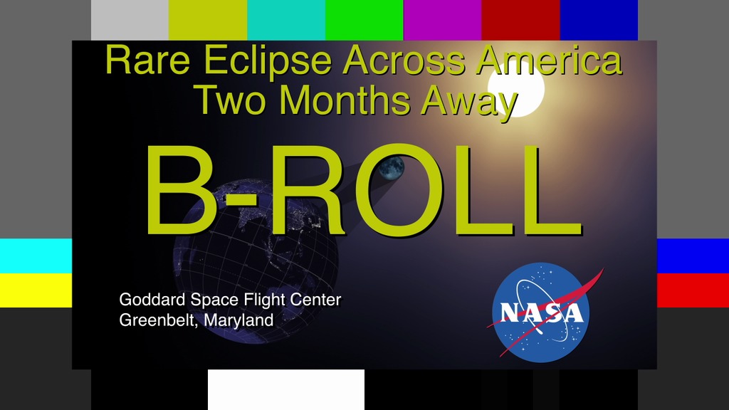
Rare Total Solar Eclipse Is Only Two Months Away Live Shots 6.21.17
Go to this pageB-roll for the live shots || eclipse_6_21_17_b-roll.00001_print.jpg (1024x576) [85.9 KB] || eclipse_6_21_17_b-roll.00001_web.png (320x180) [50.5 KB] || eclipse_6_21_17_b-roll.00001_thm.png (80x40) [5.5 KB] || eclipse_6_21_17_b-roll.00001_searchweb.png (320x180) [50.5 KB] || eclipse_6_21_17_b-roll.webm (1280x720) [40.3 MB] || eclipse_6_21_17_b-roll.mov (1280x720) [5.5 GB] ||
- ID: 12649 Produced Video

2017 Solar Eclipse Video File
Go to this pageVideo file for the 2017 eclipse || GSFC_2017Eclipse_VF_Handleman.00001_print.jpg (1024x576) [16.2 KB] || GSFC_2017Eclipse_VF_Handleman.00001_searchweb.png (320x180) [2.8 KB] || GSFC_2017Eclipse_VF_Handleman.00001_thm.png (80x40) [1.4 KB] || GSFC_2017Eclipse_VF_Handleman.webm (1280x720) [129.3 MB] || GSFC_2017Eclipse_VF_Handleman.mp4 (1280x720) [1.3 GB] || GSFC_2017Eclipse_VF_Handleman.mov (1280x720) [17.6 GB] ||
- ID: 12535 Produced Video
2017 Spring Equinox Live Shots
Go to this pageB-roll that corresponds with the following suggested questions: 1. What is an equinox?2. There is an exciting event happening this year: a total solar eclipse! When is this happening?3. NASA will be doing some pretty cool science during the eclipse. How is NASA using the eclipse to studythe sun and Earth?4. How do eclipses help us find planets orbiting other stars?5. Where can we learn more?NASA Satellites Ready When Stars and Planets Align. || Screen_Shot_2017-03-20_at_5.23.14_AM_print.jpg (1024x536) [56.1 KB] || Screen_Shot_2017-03-20_at_5.23.14_AM_print_print.jpg (1024x536) [56.4 KB] || Screen_Shot_2017-03-20_at_5.23.14_AM.png (2382x1248) [2.0 MB] || Screen_Shot_2017-03-20_at_5.23.14_AM_print_searchweb.png (320x180) [58.5 KB] || Screen_Shot_2017-03-20_at_5.23.14_AM_print_web.png (320x167) [53.5 KB] || Screen_Shot_2017-03-20_at_5.23.14_AM_print_thm.png (80x40) [5.8 KB] || eclipse_LS_Broll.webm (1280x720) [33.4 MB] || eclipse_LS_Broll.mp4 (1280x720) [349.3 MB] ||
- ID: 12165 Produced Video
2016 Total Solar Eclipse Live Shots
Go to this pageSolar Eclipse Live Shot Roll-ins || Solar_Eclipse_Rollins_h264_print.jpg (1024x576) [28.9 KB] || Solar_Eclipse_Rollins.webmhd.webm (1280x720) [23.6 MB] || Solar_Eclipse_Rollins_h264.mov (1280x720) [499.9 MB] || Solar_Eclipse_Rollins.mov (1280x720) [1.7 GB] ||
Observing The Sun
- ID: 11179 Produced Video
Space Weather Vocabulary
Go to this pageWe are all familiar with weather on Earth, but how much do you know about weather in space? Suitable for all ages, this introduction to space weather covers vocabulary like coronal mass ejection (CME), solar wind, and solar flare. It also outlines potential effects of solar storms on our planet.This video is available in English and Spanish, both with English subtitles.Todo el mundo está familiarizado con el clima de la Tierra pero, ¿cuánto sabes sobre meteorología espacial? Este video introductorio al clima espacial, apropiado para todas las edades y niveles, explica términos científicos como eyección de masa coronal, viento solar o erupción solar.También provee una descripción general sobre los efectos potenciales que tienen las tormentas solares en nuestro planeta.El vídeo está disponible en español e inglés, ambas versiones con subtítulos en inglés. ||
- ID: 12613 Produced Video
SDO 4k Slow-rotation Sun Resource Page
Go to this pageStill Image for page || SDO_Slow_Gallery.jpg (1920x1080) [235.4 KB] || SDO_Slow_Gallery_searchweb.png (320x180) [43.0 KB] || SDO_Slow_Gallery_thm.png (80x40) [3.6 KB] ||
- ID: 12614 Produced Video
SDO Anniversary Series
Go to this pageThe sun is always changing and NASA's Solar Dynamics Observatory is always watching. Launched on Feb. 11, 2010, SDO keeps a 24-hour eye on the entire disk of the sun, with a prime view of the graceful dance of solar material coursing through the sun's atmosphere, the corona.Year 1 ||
Press Conference Materials
- ID: 12646 Produced Video
2017 Solar Eclipse Press Conference
Go to this pageFor the first time in 99 years, a total solar eclipse will cross the entire nation Aug. 21. Representatives from NASA, other federal agencies, and science organizations, will provide important viewing safety, travel and science information during two briefings at the Newseum in Washington starting at 1 p.m. EDT Wednesday, June 21.The event will air live on NASA Television and stream on the agency’s website.Over the course of 100 minutes, 14 states across the United States will experience more than two minutes of darkness in the middle of the day. Additionally, a partial eclipse will be viewable across all of North America. The eclipse will provide a unique opportunity to study the sun, Earth, moon and their interaction because of the eclipse’s long path over land coast to coast. Scientists will be able to take ground-based and airborne observations over a period of an hour and a half to complement the wealth of data and images provided by space assets.The June 21 briefings are:Logistics Briefing: 1 to 2 p.m.Thomas Zurbuchen, associate administrator of NASA’s Science Mission Directorate at the agency’s headquarters in WashingtonVanessa Griffin, director of the National Oceanic and Atmospheric Administration’s Office of Satellite and Product Operations in Suitland, MarylandBrian Carlstrom, deputy associate director of Natural Resource Stewardship and Science at the National Park Service in WashingtonMartin Knopp, associate administrator of the Office of Operations in the Federal Highway Administration at the U.S. Department of Transportation in WashingtonScience Briefing: 2:30 to 3:30 p.m.Thomas ZurbuchenAngela Des Jardins, principal investigator of the Eclipse Ballooning Project at Montana State University, BozemanAngela Speck, professor of astrophysics and director of astronomy at the University of Missouri, ColumbiaDave Boboltz, program director of solar physics in the Division of Astronomical Sciences at the National Science Foundation in Arlington, VirginiaLinda Shore, executive director of the Astronomical Society of the Pacific in San FranciscoMatt Penn, astronomer at the National Solar Observatory in Tucson, Arizona ||
- ID: 12414 Produced Video
AGU 2017 Eclipse Press Conference
Go to this pageGraphic depicting the geometry of a total solar eclipse. Credit: NASA || Eclipse_Geometry.png (1158x548) [180.5 KB] ||
Past Eclipses Seen from Earth - Solar
- ID: 4427 Visualization
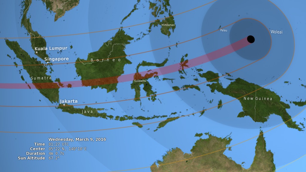
March 2016 Total Solar Eclipse Path
Go to this pageThe animated shadow path of the March 9, 2016 total solar eclipse, showing the umbra (black oval), penumbra (concentric shaded ovals), and path of totality (red) through Indonesia and the western Pacific.This video is also available on our YouTube channel. || path.0885_print.jpg (1024x576) [108.6 KB] || path.0885_searchweb.png (320x180) [76.0 KB] || path.0885_thm.png (80x40) [6.9 KB] || 2016tse_path_1080p30.mp4 (1920x1080) [21.6 MB] || 2016tse_path_720p30.mp4 (1280x720) [12.0 MB] || fancy (1920x1080) [0 Item(s)] || 2016tse_path_720p30.webm (1280x720) [6.6 MB] || 2016tse_path_360p30.mp4 (640x360) [4.8 MB] || 2016tse_path_1080p30.mp4.hwshow [186 bytes] ||
- ID: 4424 Visualization
March 2016 Eclipse Shadow Cones
Go to this pageThe umbral and penumbral shadow cones travel across the surface of the Earth during the March 9, 2016 total solar eclipse. || cones.0850_print.jpg (1024x576) [92.5 KB] || cones.0850_searchweb.png (320x180) [56.7 KB] || cones.0850_thm.png (80x40) [5.0 KB] || tse2016_cones_1080p30.mp4 (1920x1080) [19.0 MB] || tse2016_cones_720p30.mp4 (1280x720) [9.4 MB] || 1920x1080_16x9_30p (1920x1080) [0 Item(s)] || tse2016_cones_720p30.webm (1280x720) [6.8 MB] || tse2016_cones_360p30.mp4 (640x360) [3.0 MB] || tse2016_cones_1080p30.mp4.hwshow [187 bytes] ||
- ID: 4426 Visualization

March 2016 Eclipse: Earth, Moon and Sun
Go to this pageThe Moon moves right to left in its orbit around the Earth. The shadow it casts hits the Earth during the March 9, 2016 total solar eclipse. || sun_earth.0270_print.jpg (1024x576) [43.2 KB] || sun_earth.0270_searchweb.png (320x180) [38.3 KB] || sun_earth.0270_print_thm.png (80x40) [4.3 KB] || 2016tse_sun_earth_1080p30.mp4 (1920x1080) [4.7 MB] || 2016tse_sun_earth_720p30.mp4 (1280x720) [2.1 MB] || 1920x1080_16x9_30p (1920x1080) [0 Item(s)] || 2016tse_sun_earth_720p30.webm (1280x720) [3.4 MB] || 2016tse_sun_earth_360p30.mp4 (640x360) [681.1 KB] || 2016tse_sun_earth_1080p30.mp4.hwshow [191 bytes] ||
- ID: 4425 Visualization
March 2016 Eclipse and the Moon's Orbit
Go to this pageThe Moon orbits the Earth in the months prior to the March 9, 2016 (March 8 in the Americas) total solar eclipse. Viewed from above, the Moon's shadow appears to cross the Earth every month, but a side view reveals the five-degree tilt of the Moon's orbit. Its shadow only hits the Earth when the line of nodes, the fulcrum of its orbital tilt, is pointed toward the Sun. || orbit.0360_print.jpg (1024x576) [38.2 KB] || orbit.0360_searchweb.png (320x180) [38.1 KB] || orbit.0360_thm.png (80x40) [4.0 KB] || 2016tse_orbit_1080p30.mp4 (1920x1080) [3.6 MB] || 2016tse_orbit_720p30.mp4 (1280x720) [1.7 MB] || orbit (1920x1080) [0 Item(s)] || 2016tse_orbit_720p30.webm (1280x720) [3.3 MB] || 2016tse_orbit_360p30.mp4 (640x360) [594.9 KB] || 2016tse_orbit_1080p30.mp4.hwshow [187 bytes] ||
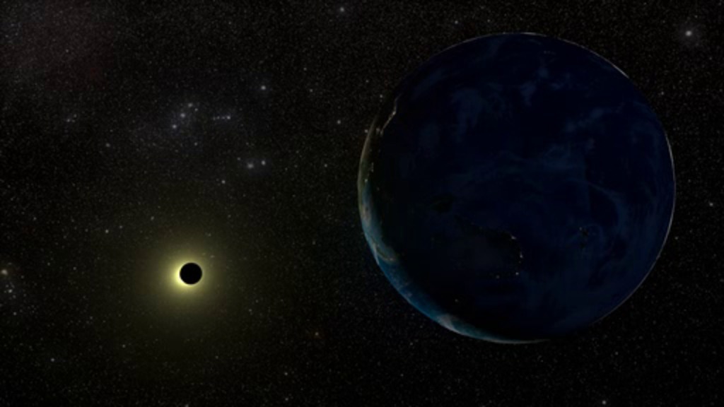
- ID: 4275 Visualization
The Total Solar Eclipse of 20 March 2015
Go to this pageThis narrated video shows visualizations of the March 20, 2015 solar eclipse from several vantage points in space, as well as an actual photo of a previous eclipse in 2012 taken by LRO from lunar orbit. Transcript. || G2015-026_ShadowOfTheMoon_print.jpg (1024x576) [96.1 KB] || G2015-026_ShadowOfTheMoon_searchweb.png (320x180) [60.2 KB] || G2015-026_ShadowOfTheMoon_thm.png (80x40) [5.0 KB] || G2015-026_ShadowOfTheMoon_youtube_hq.mov (1280x720) [35.7 MB] || G2015-026_ShadowOfTheMoon_1280x720.wmv (1280x720) [50.0 MB] || G2015-026_ShadowOfTheMoon_prores.mov (1280x720) [1.5 GB] || G2015-026_ShadowOfTheMoon_appletv.m4v (960x540) [46.5 MB] || G2015-026_ShadowOfTheMoon_appletv.webm (960x540) [14.4 MB] || G2015-026_ShadowOfTheMoon_appletv_subtitles.m4v (960x540) [46.5 MB] || G2015-026_ShadowOfTheMoon_nasaportal.mov (640x360) [34.1 MB] || G2015-026_ShadowOfTheMoon_ipod_lg.m4v (640x360) [20.0 MB] || Shadow.en_US.srt [1.9 KB] || G2015-026_ShadowOfTheMoon_ipod_sm.mp4 (320x240) [9.1 MB] ||
- ID: 4525 Visualization
LRO Images the May 2012 Solar Eclipse
Go to this pageA sequence of four images captured by the Lunar Reconnaissance Orbiter narrow-angle camera during the May 20-21, 2012 annular solar eclipse. The Moon's shadow is seen passing over Japan and the Aleutian Islands. || lroc_eclipse2012.0001_print.jpg (1024x576) [90.4 KB] || lroc_eclipse2012.0001_searchweb.png (320x180) [20.4 KB] || lroc_eclipse2012.0001_thm.png (80x40) [1.8 KB] || lroc_eclipse2012_1080p1.mp4 (1920x1080) [2.8 MB] || lroc_eclipse2012_720p1.mp4 (1280x720) [1.3 MB] || lroc_eclipse2012_720p1.webm (1280x720) [793.4 KB] || lroc_eclipse2012_720p1.wmv (1280x720) [953.9 KB] || 1920x1080_16x9_1p (1920x1080) [0 Item(s)] || lroc_eclipse2012_360p1.mp4 (640x360) [373.2 KB] || 5760x3240_16x9_1p (5760x3240) [0 Item(s)] ||
- ID: 20138 Animation
Total Solar Eclipse
Go to this pageOn Friday, 2008 August 01, a total eclipse of the Sun will be visible from within a narrow coridor that traverses half the Earth. This animation shows the Moon passing between the Earth and Sun. ||
Past Eclipses Seen from Earth - Lunar
- ID: 4356 Visualization
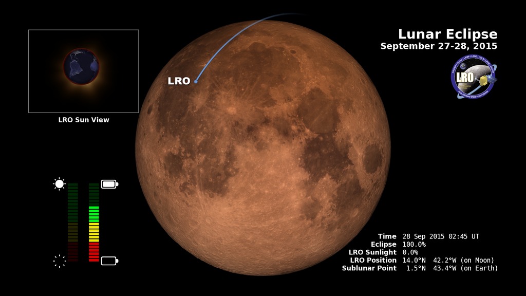
LRO and the September 27-28, 2015 Lunar Eclipse: Telescopic View
Go to this pageOn September 28, 2015 (the night of September 27), the Moon enters the Earth's shadow, creating a total lunar eclipse. This visualization simulates the view through a telescope during the eclipse while also showing the position of the LRO spacecraft.
- ID: 4155 Visualization
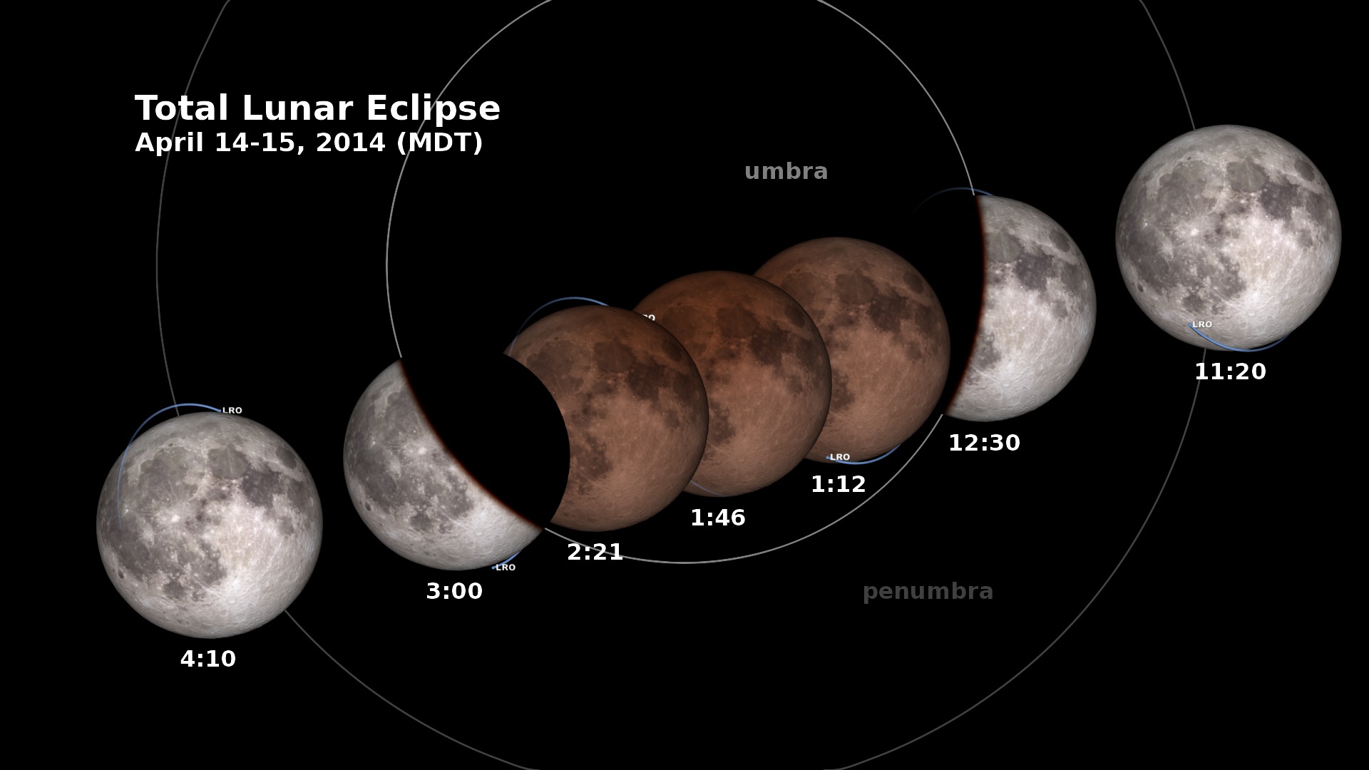
LRO and the Lunar Eclipse of April 15, 2014: Shadow View
Go to this pageIn the early morning hours of April 15, 2014, the Moon enters the Earth’s shadow, creating a total lunar eclipse, the first of four that are visible in the Western Hemisphere in the next two years. This animation shows the changing appearance of the Moon as it travels into and out of the Earth’s shadow, along with the times at various stages. Versions of the animation have been created for each of the four time zones of the contiguous United States.All of North and South America will see this eclipse, and you won’t need special equipment to see it. Just stay up late, go outside and look up!The penumbra is the part of the Earth’s shadow where the Sun is only partially covered by the Earth. The umbra is where the Sun is completely hidden.The animation includes the position of the Lunar Reconnaissance Orbiter spacecraft. LRO is powered by sunlight, but during the eclipse, it will have to rely on its battery for almost three hours. ||
- ID: 3834 Visualization
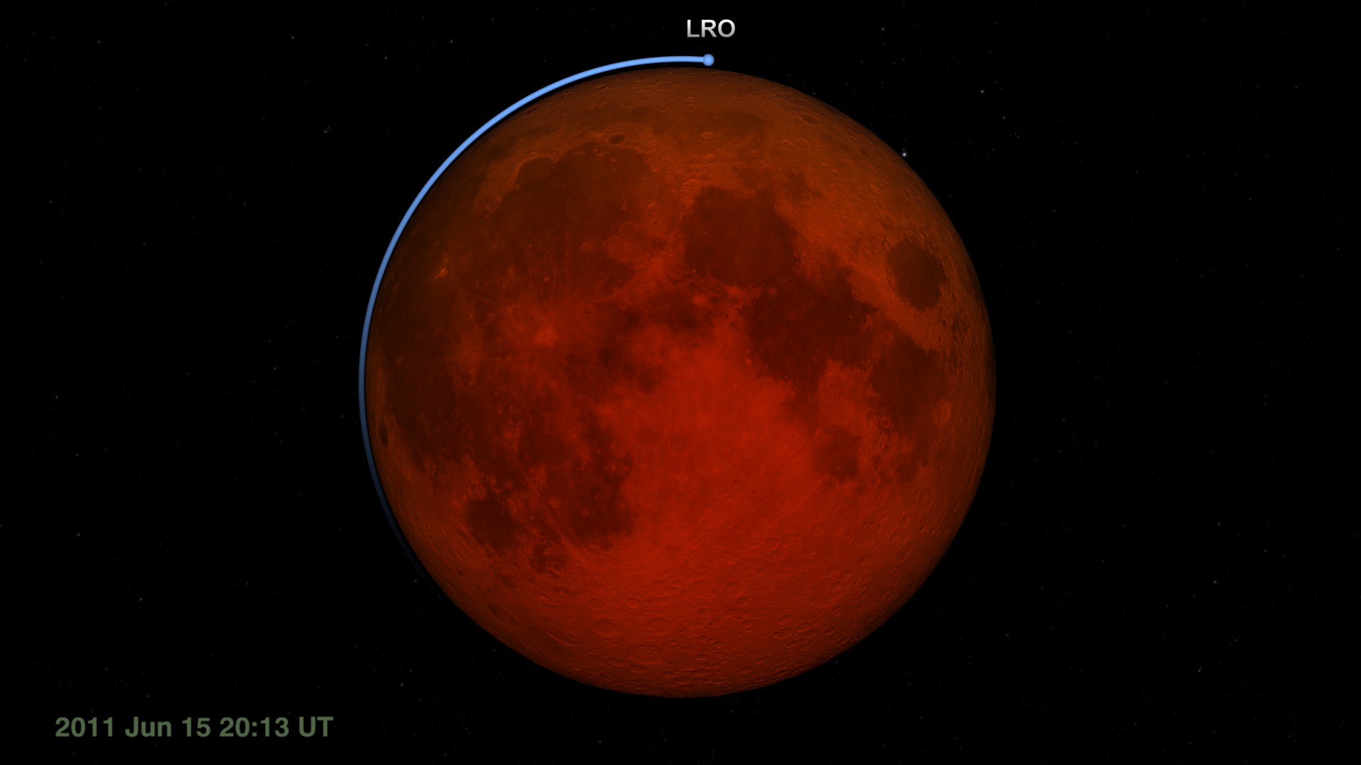
LRO at the June 15, 2011 Lunar Eclipse: Earth View
Go to this pageFor Lunar Reconnaissance Orbiter (LRO), the lunar eclipse on June 15, 2011 is likely to be the longest and darkest of its life. This matters because LRO relies on sunlight to power its systems and instruments. Although it spends half of every orbit on the night side of the Moon, each night side pass lasts only an hour. For the June 15 eclipse, LRO will be in the dark for more than twice as long.During a previous total eclipse, LRO hibernated, turning off all of its instruments to conserve its battery power until the Moon emerged from the Earth's shadow. For the June 15 event, LRO will leave on the Diviner Lunar Radiometry Experiment. Diviner will measure the cooling of the Moon's surface during the eclipse. This unique temperature record is expected to reveal information about the roughness and composition of the swath of lunar surface visible to Diviner's sensors during the eclipse.The visualization archived on this page shows the eclipse as it might appear through a telescope on Earth (except that you can't see LRO in such a telescope). Celestial north is up. As the Moon enters the umbra (the part of the shadow in which the Sun is completely blocked by the Earth), the shadowed side of the Moon appears black while the sunlit side remains bright. Only when the Moon is almost completely within the umbra is it possible to see the faint red glow of the shadowed side, some 10,000 times fainter than the sunlit Moon. The redness is sunlight filtered and refracted by Earth's atmosphere. The same effect reddens sunrises and sunsets on Earth.Other visualizations in this series depict the view of the eclipsefrom the Moon, where the event is a solar eclipsealong the shadow line, with the figures of the umbra, penumbra, and lunar and solar pathsflying above LRO as Diviner takes temperature measurementsA narrated piece that uses these visualizations is available in entry #10794. For an explanation of lunar eclipses, visit entry #10787. ||