2017 Eclipse Image Collection

This image is a composite photograph that shows the progression of the total solar eclipse over Madras, Oregon.
http://earthobservatory.nasa.gov/NaturalHazards/view.php?id=90796

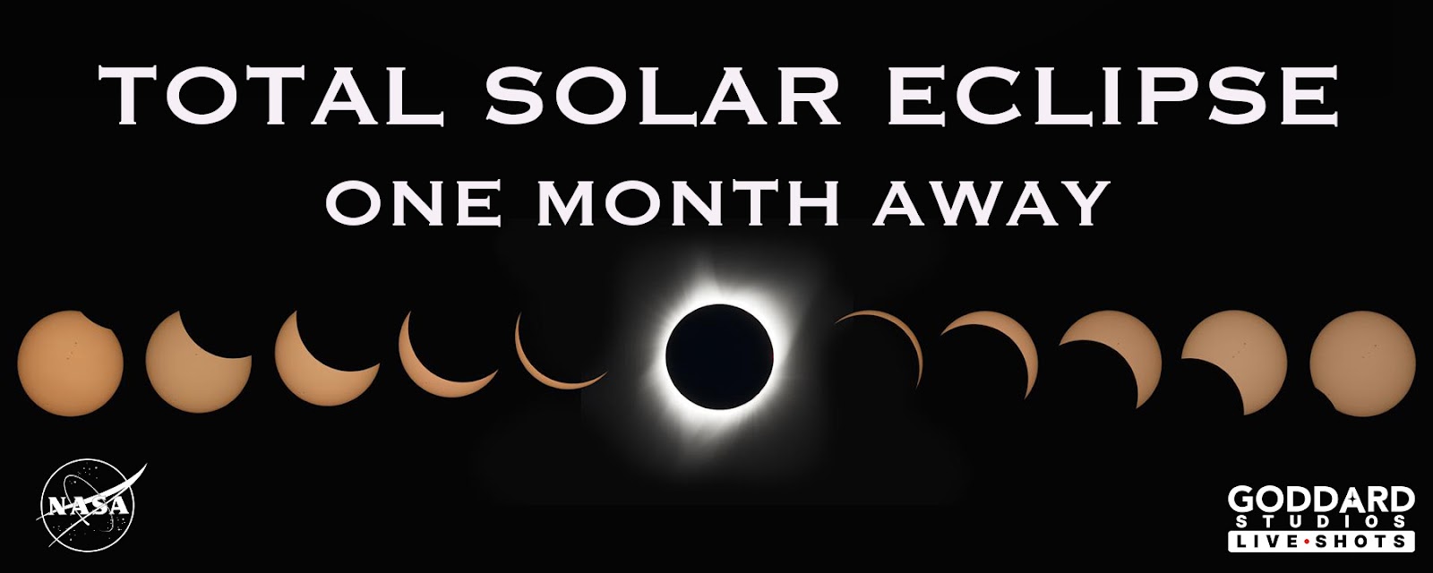
A radiant “diamond” of sunlight is seen in the moments after totality during the total solar eclipse on Aug. 21, 2017. The effect is seen in the few seconds just before and after totality when there is a single point of sunlight shining through a valley on the moon. In this image, from Jefferson City, Missouri, the sun’s corona creates a brilliant halo and forms a ring of light around the edge of the moon.
A total solar eclipse swept across a 70-mile-wide path of the continental United States for the first time in 99 years. During the rare celestial event, the moon’s shadow moved from west to east creating a diagonal path of totality in 14 states from Oregon to South Carolina. Spectators along the path of totality experienced more than 2 minutes of twilight in the middle of the day. Observers in the remainder of North America, and parts of South America, Africa and Europe saw a partial solar eclipse where the moon covered part of the sun’s disk.
Image Credits: NASA/Rami Daud, Alcyon Technical Services
Credits: "Total Solar Eclipse 2012 Education Resources." Total Solar Eclipse 2012 Education Resources. Astronomical Association of Queensland; Science Teachers Association of Queensland, 2012. Web.
https://www.nasa.gov/image-feature/a-celestial-diamond-ring-nature-s-gift-to-humanity
 as it transited the Sun at roughly 5 miles (8 kilometers) per second. It was taken on August 21, 2017, from Banner, Wyoming. On board the station as part of Expedition 52 were: NASA astronauts Peggy Whitson, Jack Fischer, and Randy Bresnik; Russian cosmonauts Fyodor Yurchikhin and Sergey Ryazanskiy; and ESA (European Space Agency) astronaut Paolo Nespoli.Credit: Bill Ingallshttp://earthobservatory.nasa.gov/NaturalHazards/view.php?id=90796")
The photograph below is a composite, made from seven frames, that shows the International Space Station (ISS) as it transited the Sun at roughly 5 miles (8 kilometers) per second. It was taken on August 21, 2017, from Banner, Wyoming. On board the station as part of Expedition 52 were: NASA astronauts Peggy Whitson, Jack Fischer, and Randy Bresnik; Russian cosmonauts Fyodor Yurchikhin and Sergey Ryazanskiy; and ESA (European Space Agency) astronaut Paolo Nespoli.
Credit: Bill Ingalls
http://earthobservatory.nasa.gov/NaturalHazards/view.php?id=90796

The total solar eclipse is seen on Monday, August 21, 2017 above Madras, Oregon. A total solar eclipse swept across a narrow portion of the contiguous United States from Lincoln Beach, Oregon to Charleston, South Carolina. A partial solar eclipse was visible across the entire North American continent along with parts of South America, Africa, and Europe.
Photo Credit: NASA/Aubrey Gemignani
From a million miles out in space, NASA’s Earth Polychromatic Imaging Camera (EPIC) captured 12 natural color images of the moon’s shadow crossing over North America on Aug. 21, 2017. EPIC is aboard NOAA’s Deep Space Climate Observatory (DSCOVR), where it photographs the full sunlit side of Earth every day, giving it a unique view of total solar eclipses. EPIC normally takes about 20 to 22 images of Earth per day, so this animation appears to speed up the progression of the eclipse.
To see the images of Earth every day, go to: https://epic.gsfc.nasa.gov
http://earthobservatory.nasa.gov/NaturalHazards/view.php?id=90796
, is superimposed over an image of the Sun’s atmosphere, called the corona (red, outermost ring), as seen by ESA (the European Space Agency) and NASA’s Solar and Heliospheric Observatory (SOHO), which watches the Sun from space. At center is an image of the sun’s surface as seen by NASA’s Solar Dynamics Observatory in extreme ultraviolet wavelengths of light.During a total solar eclipse, ground-based telescopes can observe the lowest part of the solar corona in a way that can’t be done at any other time, as the dim corona is normally obscured by the bright light of the Sun. The structure in the ground-based corona image — defined by giant magnetic fields sweeping out from the Sun’s surface — can clearly be seen extending into the outer image from the space-based telescope. The more scientists understand about the lower corona, the more they can understand what causes the constant outward stream of material called the solar wind, as well as occasional giant eruptions called coronal mass ejections.Credits:Innermost image: NASA/SDOGround-based eclipse image: Jay Pasachoff, Ron Dantowitz, Christian Lockwood and the Williams College Eclipse Expedition/NSF/National GeographicOuter image: ESA/NASA/SOHOhttps://www.nasa.gov/image-feature/goddard/2017/aug-21-solar-eclipse-from-ground-and-space")
A ground-based image of the total solar eclipse on Aug. 21, 2017 (gray, middle ring), is superimposed over an image of the Sun’s atmosphere, called the corona (red, outermost ring), as seen by ESA (the European Space Agency) and NASA’s Solar and Heliospheric Observatory (SOHO), which watches the Sun from space. At center is an image of the sun’s surface as seen by NASA’s Solar Dynamics Observatory in extreme ultraviolet wavelengths of light.
During a total solar eclipse, ground-based telescopes can observe the lowest part of the solar corona in a way that can’t be done at any other time, as the dim corona is normally obscured by the bright light of the Sun. The structure in the ground-based corona image — defined by giant magnetic fields sweeping out from the Sun’s surface — can clearly be seen extending into the outer image from the space-based telescope. The more scientists understand about the lower corona, the more they can understand what causes the constant outward stream of material called the solar wind, as well as occasional giant eruptions called coronal mass ejections.
Credits:
Innermost image: NASA/SDO
Ground-based eclipse image: Jay Pasachoff, Ron Dantowitz, Christian Lockwood and the Williams College Eclipse Expedition/NSF/National Geographic
Outer image: ESA/NASA/SOHO
https://www.nasa.gov/image-feature/goddard/2017/aug-21-solar-eclipse-from-ground-and-space
 sensor on Terra captured the data used to make this image using data from different overpasses that was collected at different times.The right third of the mosaic shows the eastern United States at about 12:10 p.m. Eastern Time (16:10 Universal Time), before the eclipse had begun. The middle part was captured at about 12:50 p.m. Central Time (17:50 Universal Time), when the eclipse was in progress in the center of the country. The left third of the image was collected at about 12:30 p.m. Pacific Time (19:30 Universal Time), after the eclipse had ended. Credit: NASA Earth Observatory images by Joshua Stevens and Jesse Allen, using MODIS data from the Land Atmosphere Near real-time Capability for EOS (LANCE) and EOSDIS/Rapid Responsehttp://earthobservatory.nasa.gov/NaturalHazards/view.php?id=90796")
2017 Total Solar Eclipse
The Moderate Resolution Imaging Spectroradiometer (MODIS) sensor on Terra captured the data used to make this image using data from different overpasses that was collected at different times.
The right third of the mosaic shows the eastern United States at about 12:10 p.m. Eastern Time (16:10 Universal Time), before the eclipse had begun. The middle part was captured at about 12:50 p.m. Central Time (17:50 Universal Time), when the eclipse was in progress in the center of the country. The left third of the image was collected at about 12:30 p.m. Pacific Time (19:30 Universal Time), after the eclipse had ended.
Credit: NASA Earth Observatory images by Joshua Stevens and Jesse Allen, using MODIS data from the Land Atmosphere Near real-time Capability for EOS (LANCE) and EOSDIS/Rapid Response
http://earthobservatory.nasa.gov/NaturalHazards/view.php?id=90796
 on Suomi NPP captured the data used to make this image using data from different overpasses that was collected at different times.The right half of the mosaic shows the eastern United States at about 2:30 p.m. Eastern Time (18:30 Universal Time), when the eclipse had reached the eastern United States. Credit: NASA Earth Observatory images by Joshua Stevens and Jesse Allen, using MODIS data from the Land Atmosphere Near real-time Capability for EOS (LANCE) and EOSDIS/Rapid Responsehttp://earthobservatory.nasa.gov/NaturalHazards/view.php?id=90796")
The Visible Infrared Imaging Radiometer Suite (VIIRS) on Suomi NPP captured the data used to make this image using data from different overpasses that was collected at different times.
The right half of the mosaic shows the eastern United States at about 2:30 p.m. Eastern Time (18:30 Universal Time), when the eclipse had reached the eastern United States.
Credit: NASA Earth Observatory images by Joshua Stevens and Jesse Allen, using MODIS data from the Land Atmosphere Near real-time Capability for EOS (LANCE) and EOSDIS/Rapid Response
http://earthobservatory.nasa.gov/NaturalHazards/view.php?id=90796
While many in the U.S. experienced a total solar eclipse on Aug. 21, 2017, NASA’s Solar Dynamics Observatory, or SDO — observing the Sun from Earth orbit — saw a partial eclipse.
SDO sees several lunar transits each year from its orbit 3,000 miles above Earth. However, an eclipse on the ground doesn’t guarantee that SDO will see anything out of the ordinary. On Aug. 21, SDO also saw the Moon briefly pass in front of the Sun at the same time that the Moon’s shadow passed over the eastern United States. SDO only saw 14 percent of the Sun blocked by the Moon, while most U.S. residents saw 60 percent blockage or more.
Credit: NASA/SDO
https://www.nasa.gov/image-feature/goddard/2017/sdos-view-of-the-aug-21-2017-solar-eclipse-animation

This composite image shows the progression of a partial solar eclipse over Ross Lake, in Northern Cascades National Park, Washington on Monday, Aug. 21, 2017. A total solar eclipse swept across a narrow portion of the contiguous United States from Lincoln Beach, Oregon to Charleston, South Carolina. A partial solar eclipse was visible across the entire North American continent along with parts of South America, Africa, and Europe.
Photo Credit: NASA/Bill Ingalls
 Paolo Nespoli, and Roscosmos’ Commander Fyodor Yurchikhin and Sergey Ryazanskiy. The space station crossed the path of the eclipse three times as it orbited above the continental United States at an altitude of 250 miles.Image Credit: NASAhttps://www.nasa.gov/image-feature/the-eclipse-2017-umbra-viewed-from-space-2")
As millions of people across the United States experienced a total eclipse as the umbra, or moon’s shadow passed over them, only six people witnessed the umbra from space. Viewing the eclipse from orbit were NASA’s Randy Bresnik, Jack Fischer and Peggy Whitson, ESA (European Space Agency’s) Paolo Nespoli, and Roscosmos’ Commander Fyodor Yurchikhin and Sergey Ryazanskiy. The space station crossed the path of the eclipse three times as it orbited above the continental United States at an altitude of 250 miles.
Image Credit: NASA
https://www.nasa.gov/image-feature/the-eclipse-2017-umbra-viewed-from-space-2

The Baily's Beads effect is seen as the moon makes its final move over the sun during the total solar eclipse on Monday, August 21, 2017 above Madras, Oregon. A total solar eclipse swept across a narrow portion of the contiguous United States from Lincoln Beach, Oregon to Charleston, South Carolina. A partial solar eclipse was visible across the entire North American continent along with parts of South America, Africa, and Europe.
Photo Credit: NASA/Aubrey Gemignani
https://www.nasa.gov/image-feature/the-baileys-beads-effect-during-the-2017-total-solar-eclipse
Photograph of Aug. 21, 2017, solar eclipse, as seen from the Gary L. Pittman Memorial Park in Greenville, South Carolina.
Image courtesy Jim Jeletic, Hubble Space Telescope deputy project manager, and his son Jordan
https://www.nasa.gov/image-feature/goddard/2017/solar-eclipse-from-greenville-sc
As millions of Americans watched the total solar eclipse that crossed the continental United States Aug. 21, the international Hinode solar observation satellite captured its own images of the awe-inspiring natural phenomenon as it orbited the planet. Researchers adapted the still images into a time-lapse video presentation.
Among its many solar research tasks, the satellite's observation of the eclipse was intended to add new data to ongoing scientific study of the coronal structure in the Sun's polar region and the mechanism of jets of superheated plasma frequently created there. These powerful jets can sometimes erupt 10 million to 12 million miles into space.
The images were taken with Hinode's X-ray telescope (XRT) as it flew above the Pacific Ocean, off the west coast of the United States, at an altitude of approximately 422 miles (680 km).
Hinode is a joint endeavor by the Japan Aerospace Exploration Agency, the National Astronomical Observatory of Japan, the European Space Agency, the United Kingdom Space Agency and NASA.
For more information about Hinode, visit:
https://www.nasa.gov/mission_pages/hinode/index.html
Credits
Please give credit for this item to:
NASA's Goddard Space Flight Center
-
Technical support
- Amy Moran (Global Science and Technology, Inc.)
Related
- ID: 14557
![Music Credit: “Corals Instrumental” by Marc Burh [GEMA], Marek Nichel [GEMA] via Universal Production MusicAdditional photographs and footage: Unsplash, Videvo](/vis/a010000/a014500/a014557/14557_EclipsePhotoTips_Thumbnail.png) Produced Video
Produced Video - ID: 14537
 Produced Video
Used as a Source In
- ID: 14562
 Produced Video
 - ID: 14427
![Watch this video on the NASA Goddard YouTube channel.Complete transcript available.Music credit: "Creativity" by Max van Thun [GEMA] from Universal Production Music.](/vis/a010000/a014400/a014427/Thumbnail_01.jpg) Produced Video
Produced Video
Release date
This page was originally published on Thursday, August 31, 2017.
This page was last updated on Friday, October 11, 2024 at 12:26 AM EDT.