Planets and Moons
ID: 4619
In the fall of 2011, the Lunar Reconnaissance Orbiter (LRO) mission released its original Tour of the Moon, a five-minute animation that takes the viewer on a virtual tour of our nearest neighbor in space. Six years later, the tour has been recreated in eye-popping 4K resolution, using the same camera path and drawing from the vastly expanded data trove collected by LRO in the intervening years.
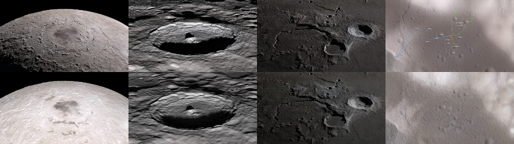
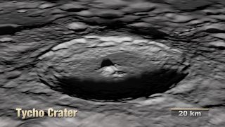
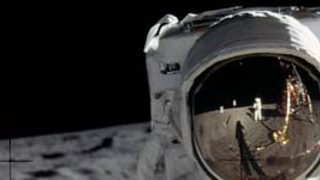
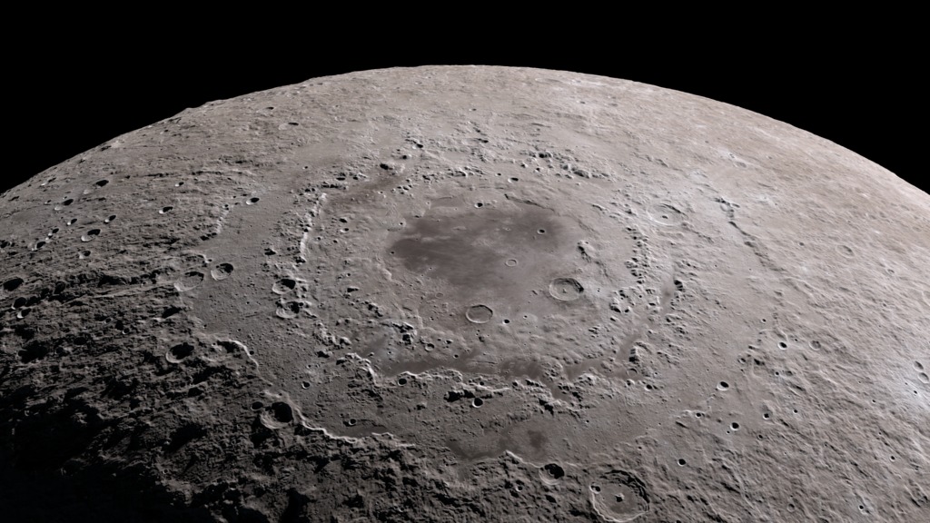
The tour visits a number of interesting sites chosen to illustrate a variety of lunar terrain features. Some are on the near side and are familiar to both professional and amateur observers on Earth, while others can only be seen clearly from space. Some are large and old (Orientale, South Pole-Aitken), others are smaller and younger (Tycho, Aristarchus). Constantly shadowed areas near the poles are hard to photograph but easier to measure with altimetry, while several of the Apollo landing sites, all relatively near the equator, have been imaged at resolutions as high as 25 centimeters (10 inches) per pixel.
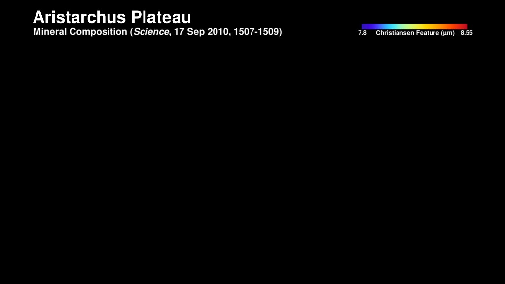
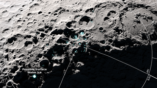
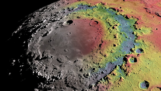
The new tour highlights the mineral composition of the Aristarchus plateau, evidence for surface water ice in certain spots near the south pole, and the mapping of gravity in and around the Orientale basin.
Tour of the Moon 4K Redux
The tour visits a number of interesting sites chosen to illustrate a variety of lunar terrain features. Some are on the near side and are familiar to both professional and amateur observers on Earth, while others can only be seen clearly from space. Some are large and old (Orientale, South Pole-Aitken), others are smaller and younger (Tycho, Aristarchus). Constantly shadowed areas near the poles are hard to photograph but easier to measure with altimetry, while several of the Apollo landing sites, all relatively near the equator, have been imaged at resolutions as high as 25 centimeters (10 inches) per pixel.
The new tour highlights the mineral composition of the Aristarchus plateau, evidence for surface water ice in certain spots near the south pole, and the mapping of gravity in and around the Orientale basin.
Used Elsewhere In
Older Version
Related

Visualization Credits
Ernie Wright (USRA): Lead Visualizer
David Ladd (USRA): Lead Producer
David Ladd (USRA): Lead Video Editor
Noah Petro (NASA/GSFC): Lead Scientist
David Ladd (USRA): Lead Producer
David Ladd (USRA): Lead Video Editor
Noah Petro (NASA/GSFC): Lead Scientist
Please give credit for this item to:
NASA's Scientific Visualization Studio
NASA's Scientific Visualization Studio
Short URL to share this page:
https://svs.gsfc.nasa.gov/4619
Missions:
GRAIL
LRO (Lunar Reconnaissance Orbiter)
Data Used:
Note: While we identify the data sets used in these visualizations, we do not store any further details nor the data sets themselves on our site.
Keywords:
SVS >> Elevation data
SVS >> Flyover
SVS >> HDTV
SVS >> Laser Altimeter
SVS >> Lunar
SVS >> Moon
SVS >> Hyperwall
SVS >> LRO
SVS >> Lunar Reconnaissance Orbiter
SVS >> LOLA
SVS >> LROC
SVS >> Diviner Lunar Radiometer Experiment (DLRE)
SVS >> Lunar Topography
SVS >> Solar System >> Moon >> Lunar Surface
SVS >> Apollo 17
NASA Science >> Planets and Moons
SVS >> 4K
https://svs.gsfc.nasa.gov/4619
Missions:
GRAIL
LRO (Lunar Reconnaissance Orbiter)
Data Used:
LRO/Diviner
LRO/LROC/Narrow Angle Camera also referred to as: NAC
LRO/LOLA/Digital Elevation Map also referred to as: DEM
GRAIL/Lunar Gravity Ranging System/Free-Air Gravity also referred to as: GRAIL Free-Air Gravity
Analysis - NASALRO/LROC/WAC 643nm High Sun Global Mosaic
MosaicLRO/SELENE/LOLA/TC/DIgital Elevation Model also referred to as: SLDEM2015
Model
A digital elevation model of the Moon derived from the Lunar Orbiter Laser Altimeter and the SELENE Terrain Camera. See the description in Icarus. The data is here.
Keywords:
SVS >> Elevation data
SVS >> Flyover
SVS >> HDTV
SVS >> Laser Altimeter
SVS >> Lunar
SVS >> Moon
SVS >> Hyperwall
SVS >> LRO
SVS >> Lunar Reconnaissance Orbiter
SVS >> LOLA
SVS >> LROC
SVS >> Diviner Lunar Radiometer Experiment (DLRE)
SVS >> Lunar Topography
SVS >> Solar System >> Moon >> Lunar Surface
SVS >> Apollo 17
NASA Science >> Planets and Moons
SVS >> 4K


