Planets and Moons
ID: 4041
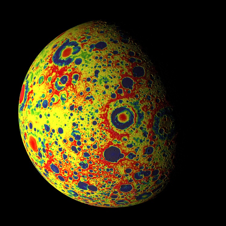
These print-resolution stills were created for the cover of the February 8, 2013 issue of Science. They show the free-air gravity map developed by the Gravity Recovery and Interior Laboratory (GRAIL) mission.
If the Moon were a perfectly smooth sphere of uniform density, the gravity map would be a single, featureless color, indicating that the force of gravity at a given elevation was the same everywhere. But like other rocky bodies in the solar system, including Earth, the Moon has both a bumpy surface and a lumpy interior. Spacecraft in orbit around the Moon experience slight variations in gravity caused by both of these irregularities.
The free-air gravity map shows deviations from the mean, the gravity that a cueball Moon would have. The deviations are measured in milliGals, a unit of acceleration. On the map, dark purple is at the low end of the range, at around -400 mGals, and red is at the high end near +400 mGals. Yellow denotes the mean.
These views show a part of the Moon's surface that's never visible from Earth. They are centered on lunar coordinates 29°N 142°E. The large, multi-ringed impact feature near the center is Mare Moscoviense. The crater Mendeleev is south of this. The digital elevation model for the terrain is from the Lunar Reconnaissance Orbiter laser altimeter (LOLA). Merely for plausibility, the sun angle and starry background are accurate for specific dates (December 21, 2012, 0:00 UT and January 8, 2013, 14:00 UT, respectively).


GRAIL Free-Air Gravity Map for the Cover of Science
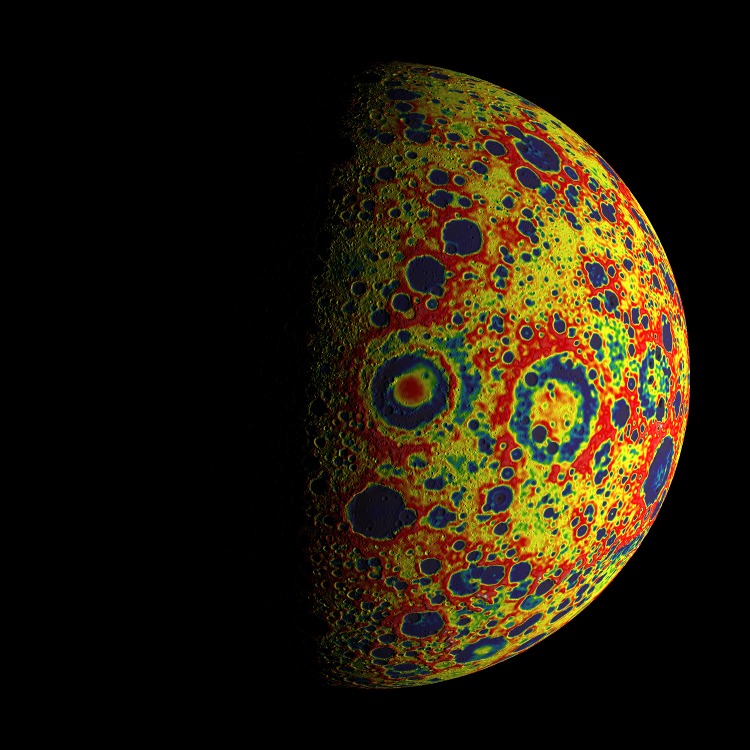
If the Moon were a perfectly smooth sphere of uniform density, the gravity map would be a single, featureless color, indicating that the force of gravity at a given elevation was the same everywhere. But like other rocky bodies in the solar system, including Earth, the Moon has both a bumpy surface and a lumpy interior. Spacecraft in orbit around the Moon experience slight variations in gravity caused by both of these irregularities.
The free-air gravity map shows deviations from the mean, the gravity that a cueball Moon would have. The deviations are measured in milliGals, a unit of acceleration. On the map, dark purple is at the low end of the range, at around -400 mGals, and red is at the high end near +400 mGals. Yellow denotes the mean.
These views show a part of the Moon's surface that's never visible from Earth. They are centered on lunar coordinates 29°N 142°E. The large, multi-ringed impact feature near the center is Mare Moscoviense. The crater Mendeleev is south of this. The digital elevation model for the terrain is from the Lunar Reconnaissance Orbiter laser altimeter (LOLA). Merely for plausibility, the sun angle and starry background are accurate for specific dates (December 21, 2012, 0:00 UT and January 8, 2013, 14:00 UT, respectively).
Related

Visualization Credits
Ernie Wright (USRA): Lead Animator
Erwan M. Mazarico (Massachusetts Institute of Technology): Scientist
Maria Zuber (Massachusetts Institute of Technology): Scientist
David E. Smith (NASA/GSFC): Scientist
Gregory A. Neumann (NASA/GSFC): Scientist
Erwan M. Mazarico (Massachusetts Institute of Technology): Scientist
Maria Zuber (Massachusetts Institute of Technology): Scientist
David E. Smith (NASA/GSFC): Scientist
Gregory A. Neumann (NASA/GSFC): Scientist
Please give credit for this item to:
NASA's Goddard Space Flight Center Scientific Visualization Studio
NASA's Goddard Space Flight Center Scientific Visualization Studio
Science Paper:
Science vol. 339 no. 6120 (February 8, 2013)
Short URL to share this page:
https://svs.gsfc.nasa.gov/4041
Mission:
GRAIL
Data Used:
Note: While we identify the data sets used in these visualizations, we do not store any further details nor the data sets themselves on our site.
This item is part of this series:
The Moon
Keywords:
SVS >> Gravity
SVS >> Lunar
SVS >> Moon
SVS >> Hyperwall
SVS >> Lunar Topography
SVS >> Lunar Elevation Map
SVS >> Satellites >> Lunar
NASA Science >> Planets and Moons
SVS >> GRAIL
SVS >> Gravity Recovery and Interior Laboratory
Science vol. 339 no. 6120 (February 8, 2013)
Short URL to share this page:
https://svs.gsfc.nasa.gov/4041
Mission:
GRAIL
Data Used:
GRAIL/Lunar Gravity Ranging System/Free-Air Gravity also referred to as: GRAIL Free-Air Gravity
Analysis - NASA - 2012Hipparcos/Telescope/Tycho 2 Catalogue also referred to as: Tycho Catalogue
DatabaseU.S. Naval Observatory/Third CCD Astrograph/Catalog also referred to as: UCAC3
Database - USNOYale Bright Star Catalogue also referred to as: Bright Star Catalogue
Database - YaleThis item is part of this series:
The Moon
Keywords:
SVS >> Gravity
SVS >> Lunar
SVS >> Moon
SVS >> Hyperwall
SVS >> Lunar Topography
SVS >> Lunar Elevation Map
SVS >> Satellites >> Lunar
NASA Science >> Planets and Moons
SVS >> GRAIL
SVS >> Gravity Recovery and Interior Laboratory


