Sea Ice Growth Slows In Arctic

Arctic sea ice was at a record low wintertime maximum extent for the second straight year.
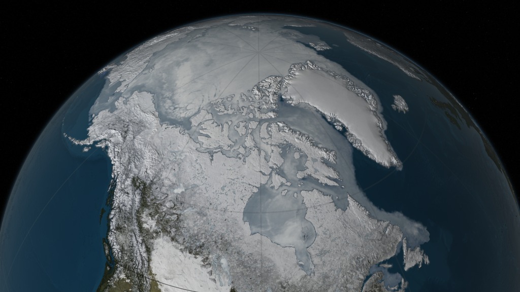
Every year, the cap of frozen seawater floating on top of the Arctic Ocean and its neighboring seas melts during the spring and summer and grows back in the fall and winter months, reaching its maximum yearly extent between February and April. On March 24, Arctic sea ice extent peaked at 5.607 million square miles, a new record low winter maximum extent in the satellite record that started in 1979. It is slightly smaller than the previous record low maximum extent of 5.612 million square miles that occurred last year. The new record low follows record high temperatures in December, January and February around the globe and in the Arctic. Scientists say as temperatures in the atmosphere and oceans continue to warm, we can expect to keep seeing smaller wintertime maximums in the future. Watch the video for a NASA visualization that shows the growth of Arctic sea ice from its 2015 summertime minimum extent to its 2016 winter maximum.
This visualization shows the Arctic sea ice freeze cycle from Sept. 7, 2015, up to this year’s winter maximum on Mar. 24, 2016.
Wind patterns in the Arctic during January and February 2016 brought warm air from the south and prevented expansion of the ice cover.
This year's Arctic sea ice maximum extent (shown above) covers an area of 5.607 million square miles, and is the lowest in the satellite record.
The orange line above shows how this year's sea ice pack compares to the average maximum coverage in March observed from 1981-2010.
For More Information
See NASA.gov
Credits
Please give credit for this item to:
NASA's Scientific Visualization Studio
-
Writer
- Maria-Jose Vinas Garcia (Telophase)
-
Animator
-
Cindy Starr
(Global Science and Technology, Inc.)

-
Cindy Starr
(Global Science and Technology, Inc.)
-
Scientists
- Walt Meier (NASA/GSFC)
- Josefino Comiso (NASA/GSFC)
-
Producers
- Jefferson Beck (USRA)
- Maria-Jose Vinas Garcia (Telophase)
- Michelle Handleman (USRA)
-
Project support
- Robert Gersten (Wyle Information Systems)
Sources
- ID: 4440
 Visualization
Release date
This page was originally published on Tuesday, April 5, 2016.
This page was last updated on Wednesday, May 3, 2023 at 1:48 PM EDT.