Earth
ID: 30486
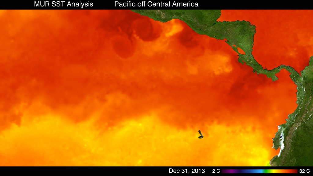
This animation from Jan 2011 to Dec 2013 shows high resolution sea surface temperature (SST) in the Eastern Pacific off Central America. Clearly visible off the Central American Coast are the cooling events associated with the winds that blow through the mountain gaps in Central America. The cooling events can form cold eddies and domes, such as off the coast of Costa Rica.
Sea Surface Temperature in the Eastern Pacific
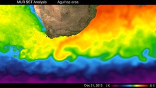
The MUR SST dataset combines data from the Advanced Very High Resolution Radiometer (AVHRR), Moderate Resolution Imaging Spectroradiometer (MODIS), and Advanced Microwave Scanning Radiometer for EOS (AMSR-E) instruments, and currently the NAVY Windsat Satellite. More details of the MUR data set may be found at PO.DAAC.
Related
For More Information
Credits
Please give credit for this item to:
NASA
NASA
Short URL to share this page:
https://svs.gsfc.nasa.gov/30486
Data Used:
Note: While we identify the data sets used in these visualizations, we do not store any further details nor the data sets themselves on our site.
Keywords:
SVS >> HDTV
GCMD >> Earth Science >> Oceans >> Ocean Circulation >> Ocean Currents
GCMD >> Earth Science >> Oceans >> Ocean Temperature >> Sea Surface Temperature
GCMD >> Location >> Eastern Pacific Ocean
SVS >> Hyperwall
NASA Science >> Earth
SVS >> Presentation
GCMD keywords can be found on the Internet with the following citation: Olsen, L.M., G. Major, K. Shein, J. Scialdone, S. Ritz, T. Stevens, M. Morahan, A. Aleman, R. Vogel, S. Leicester, H. Weir, M. Meaux, S. Grebas, C.Solomon, M. Holland, T. Northcutt, R. A. Restrepo, R. Bilodeau, 2013. NASA/Global Change Master Directory (GCMD) Earth Science Keywords. Version 8.0.0.0.0
https://svs.gsfc.nasa.gov/30486
Data Used:
Multi-scale Ultra-high Resolution (MUR) Sea Surface Temperature (SST) Analysis also referred to as: MUR SST
Analysis - JPL PO DAACKeywords:
SVS >> HDTV
GCMD >> Earth Science >> Oceans >> Ocean Circulation >> Ocean Currents
GCMD >> Earth Science >> Oceans >> Ocean Temperature >> Sea Surface Temperature
GCMD >> Location >> Eastern Pacific Ocean
SVS >> Hyperwall
NASA Science >> Earth
SVS >> Presentation
GCMD keywords can be found on the Internet with the following citation: Olsen, L.M., G. Major, K. Shein, J. Scialdone, S. Ritz, T. Stevens, M. Morahan, A. Aleman, R. Vogel, S. Leicester, H. Weir, M. Meaux, S. Grebas, C.Solomon, M. Holland, T. Northcutt, R. A. Restrepo, R. Bilodeau, 2013. NASA/Global Change Master Directory (GCMD) Earth Science Keywords. Version 8.0.0.0.0


