Earth
ID: 5100
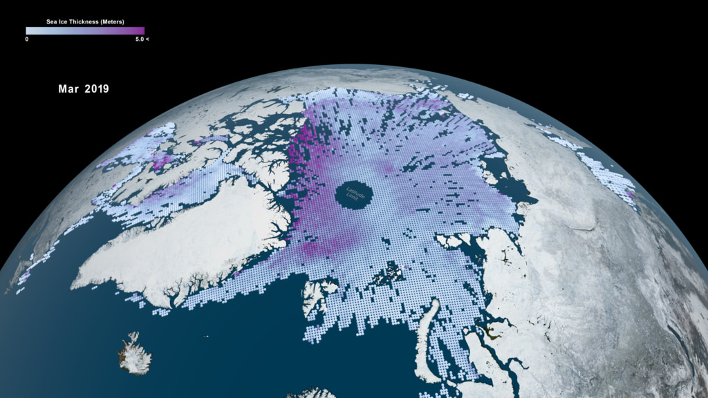
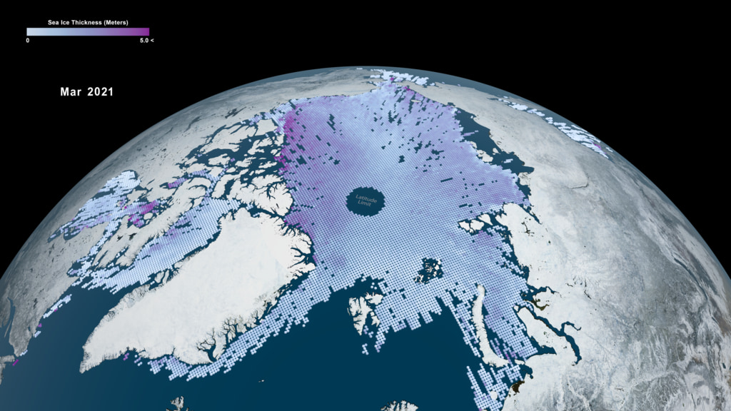
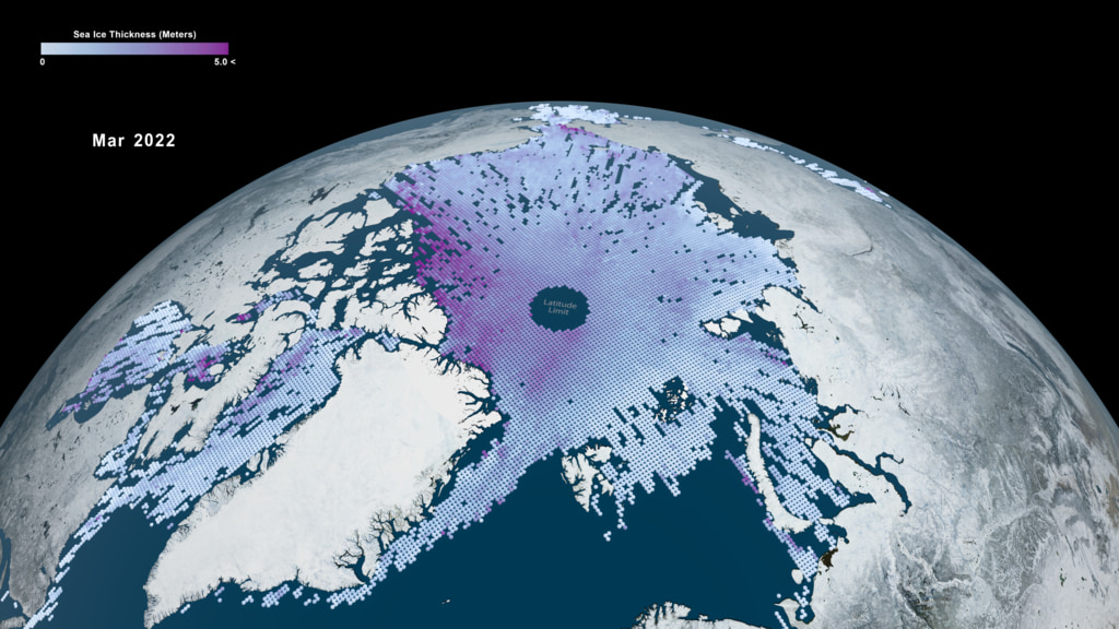
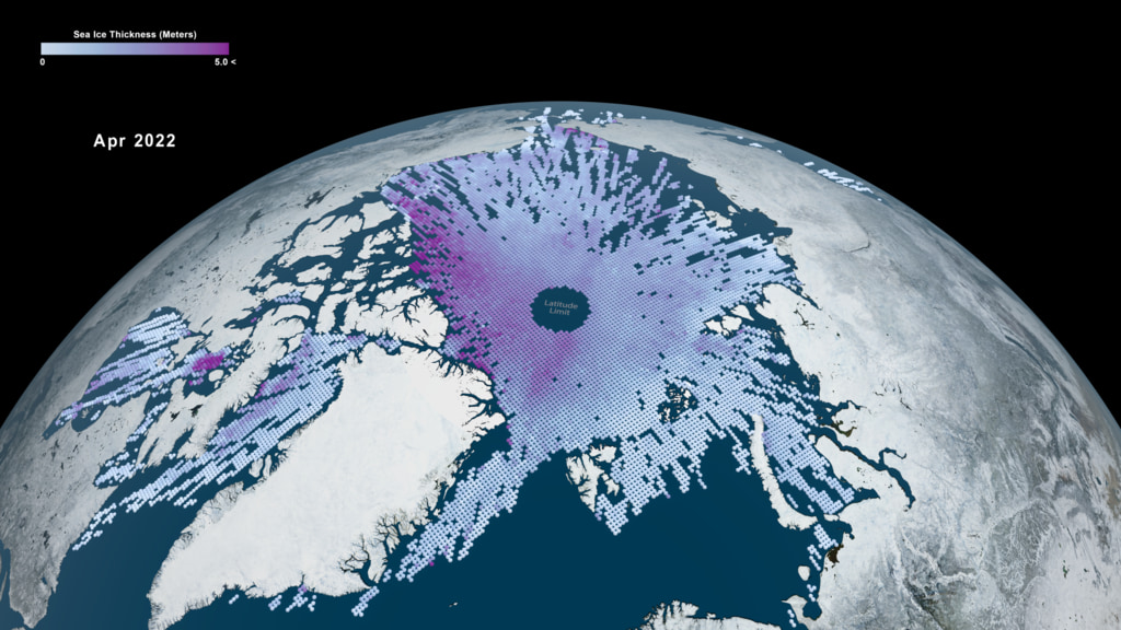
One of the big challenges in polar science is measuring the thickness of the floating sea ice that blankets the Arctic and Southern Oceans. Newly formed sea ice might be only a few inches thick, whereas sea ice that survives several winter seasons can grow to several feet in thickness (over ten feet in some places).
Sea ice thickness is typically estimated by first measuring sea ice freeboard - how much of the floating ice can be observed above sea level. Sea ice floats slightly above sea level because it is less dense than water.
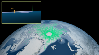
NASA’s ICESat-2 satellite measures the Earth’s surface height by firing green laser pulses towards Earth and timing how long it takes for those laser pulses to reflect back to the satellite. Ice freeboard is calculated by differencing the heights of the ice surface and areas of open water next to the ice. Additional information including the depth and density of the snow layer on top of the ice is needed to convert this freeboard measurement to sea ice thickness. New state-of-the-art snow accumulation models have been developed to provide this extra data in preparation for the launch of ICESat-2.
The very high precision of the ICESat-2 laser has enabled us for to measure the thickness of very thin sea ice for the first time. As the Arctic warms rapidly it is becoming increasingly dominated by a younger and thinner ice cover, making these new measurements extremely invaluable for understanding our changing polar regions.


ICESat-2 Sea Ice Thickness 2023
Sea ice thickness is typically estimated by first measuring sea ice freeboard - how much of the floating ice can be observed above sea level. Sea ice floats slightly above sea level because it is less dense than water.
NASA’s ICESat-2 satellite measures the Earth’s surface height by firing green laser pulses towards Earth and timing how long it takes for those laser pulses to reflect back to the satellite. Ice freeboard is calculated by differencing the heights of the ice surface and areas of open water next to the ice. Additional information including the depth and density of the snow layer on top of the ice is needed to convert this freeboard measurement to sea ice thickness. New state-of-the-art snow accumulation models have been developed to provide this extra data in preparation for the launch of ICESat-2.
The very high precision of the ICESat-2 laser has enabled us for to measure the thickness of very thin sea ice for the first time. As the Arctic warms rapidly it is becoming increasingly dominated by a younger and thinner ice cover, making these new measurements extremely invaluable for understanding our changing polar regions.
Older Version
Related
Visualization Credits
Kel Elkins (USRA): Visualizer
Ryan Fitzgibbons (KBR Wyle Services, LLC): Producer
Alek A. Petty (University of Maryland): Scientist
Thomas A. Neumann (NASA/GSFC): Scientist
Nathan T. Kurtz (NASA/GSFC): Scientist
Ryan Fitzgibbons (KBR Wyle Services, LLC): Producer
Alek A. Petty (University of Maryland): Scientist
Thomas A. Neumann (NASA/GSFC): Scientist
Nathan T. Kurtz (NASA/GSFC): Scientist
Please give credit for this item to:
NASA's Scientific Visualization Studio
NASA's Scientific Visualization Studio
Short URL to share this page:
https://svs.gsfc.nasa.gov/5100
Data Used:
Note: While we identify the data sets used in these visualizations, we do not store any further details nor the data sets themselves on our site.
This item is part of this series:
ICESat
Keywords:
SVS >> Sea Ice
GCMD >> Earth Science >> Cryosphere >> Sea Ice >> Sea Ice Elevation
SVS >> Hyperwall
NASA Science >> Earth
SVS >> ICESat-2
SVS >> Sea Ice Thickness
NASA Earth Science Focus Areas >> Climate Variability and Change
GCMD keywords can be found on the Internet with the following citation: Olsen, L.M., G. Major, K. Shein, J. Scialdone, S. Ritz, T. Stevens, M. Morahan, A. Aleman, R. Vogel, S. Leicester, H. Weir, M. Meaux, S. Grebas, C.Solomon, M. Holland, T. Northcutt, R. A. Restrepo, R. Bilodeau, 2013. NASA/Global Change Master Directory (GCMD) Earth Science Keywords. Version 8.0.0.0.0
https://svs.gsfc.nasa.gov/5100
Data Used:
ICESat-2/Advanced Topographic Laser Altimeter System (ATLAS)/Sea Ice Freeboard
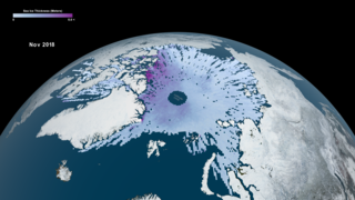
Nov 2018 - April 2021This item is part of this series:
ICESat
Keywords:
SVS >> Sea Ice
GCMD >> Earth Science >> Cryosphere >> Sea Ice >> Sea Ice Elevation
SVS >> Hyperwall
NASA Science >> Earth
SVS >> ICESat-2
SVS >> Sea Ice Thickness
NASA Earth Science Focus Areas >> Climate Variability and Change
GCMD keywords can be found on the Internet with the following citation: Olsen, L.M., G. Major, K. Shein, J. Scialdone, S. Ritz, T. Stevens, M. Morahan, A. Aleman, R. Vogel, S. Leicester, H. Weir, M. Meaux, S. Grebas, C.Solomon, M. Holland, T. Northcutt, R. A. Restrepo, R. Bilodeau, 2013. NASA/Global Change Master Directory (GCMD) Earth Science Keywords. Version 8.0.0.0.0


