Planets and Moons
ID: 4714
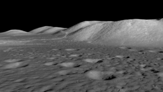
The Lee Lincoln scarp is a low ridge or step about 80 meters high and running north-south through the western end of the Taurus-Littrow valley, site of the Apollo 17 Moon landing. This lobate scarp marks the location of a relatively young, low-angle thrust fault. The land west of the fault was forced up and over the eastern side as the lunar crust contracted.
In a May 2019 paper published in Nature Geoscience, Thomas Watters and his coauthors provide evidence that this fault and others like it are still active and producing moonquakes today. Seismometers left on the Moon by Apollo astronauts recorded hundreds of events between 1969 and 1977, including 28 shallow moonquakes. The study narrowed the locations of these quakes and found that many of them occurred near scarps, implying that the forces creating the scarps also caused the quakes, and they continue to shape the lunar surface. The Lee Lincoln scarp was only about 13 kilometers from one of the epicenters identified by the scientists.
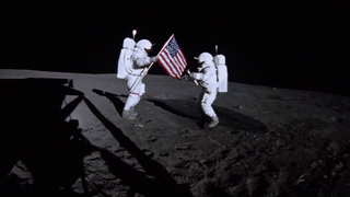
The Apollo 17 astronauts drove their lunar rover onto the scarp during their second day on the lunar surface, and this remains the only extraterrestrial scarp visited by humans.
Lee Lincoln Scarp at the Apollo 17 Landing Site
In a May 2019 paper published in Nature Geoscience, Thomas Watters and his coauthors provide evidence that this fault and others like it are still active and producing moonquakes today. Seismometers left on the Moon by Apollo astronauts recorded hundreds of events between 1969 and 1977, including 28 shallow moonquakes. The study narrowed the locations of these quakes and found that many of them occurred near scarps, implying that the forces creating the scarps also caused the quakes, and they continue to shape the lunar surface. The Lee Lincoln scarp was only about 13 kilometers from one of the epicenters identified by the scientists.
The Apollo 17 astronauts drove their lunar rover onto the scarp during their second day on the lunar surface, and this remains the only extraterrestrial scarp visited by humans.
Alternate Version
Related
For More Information
Visualization Credits
Ernie Wright (USRA): Lead Visualizer
David Ladd (USRA): Producer
Tom Watters (Smithsonian/Air and Space): Scientist
David Ladd (USRA): Producer
Tom Watters (Smithsonian/Air and Space): Scientist
Please give credit for this item to:
NASA's Scientific Visualization Studio
NASA's Scientific Visualization Studio
Science Paper:
Shallow seismic activity and young thrust faults on the Moon
Short URL to share this page:
https://svs.gsfc.nasa.gov/4714
Mission:
LRO (Lunar Reconnaissance Orbiter)
Data Used:
Note: While we identify the data sets used in these visualizations, we do not store any further details nor the data sets themselves on our site.
Keywords:
SVS >> Flyover
DLESE >> Geology
SVS >> HDTV
SVS >> Lunar
SVS >> Moon
GCMD >> Earth Science >> Solid Earth >> Tectonics >> Faults
SVS >> Hyperwall
SVS >> LRO
SVS >> Lunar Reconnaissance Orbiter
SVS >> LOLA
SVS >> LROC
SVS >> Lunar Topography
SVS >> Solar System >> Moon >> Lunar Surface
SVS >> Apollo 17
NASA Science >> Planets and Moons
GCMD >> Earth Science >> Solid Earth >> Tectonics >> Earthquakes
GCMD keywords can be found on the Internet with the following citation: Olsen, L.M., G. Major, K. Shein, J. Scialdone, S. Ritz, T. Stevens, M. Morahan, A. Aleman, R. Vogel, S. Leicester, H. Weir, M. Meaux, S. Grebas, C.Solomon, M. Holland, T. Northcutt, R. A. Restrepo, R. Bilodeau, 2013. NASA/Global Change Master Directory (GCMD) Earth Science Keywords. Version 8.0.0.0.0
Shallow seismic activity and young thrust faults on the Moon
Short URL to share this page:
https://svs.gsfc.nasa.gov/4714
Mission:
LRO (Lunar Reconnaissance Orbiter)
Data Used:
LRO/LROC/Narrow Angle Camera also referred to as: NAC
LRO/LROC NAC/Stereo DEM
ModelLRO/Wide Angle Camera also referred to as: LROC WAC
Observed DataLRO/SELENE/LOLA/TC/DIgital Elevation Model also referred to as: SLDEM2015
Model
A digital elevation model of the Moon derived from the Lunar Orbiter Laser Altimeter and the SELENE Terrain Camera. See the description in Icarus. The data is here.
Keywords:
SVS >> Flyover
DLESE >> Geology
SVS >> HDTV
SVS >> Lunar
SVS >> Moon
GCMD >> Earth Science >> Solid Earth >> Tectonics >> Faults
SVS >> Hyperwall
SVS >> LRO
SVS >> Lunar Reconnaissance Orbiter
SVS >> LOLA
SVS >> LROC
SVS >> Lunar Topography
SVS >> Solar System >> Moon >> Lunar Surface
SVS >> Apollo 17
NASA Science >> Planets and Moons
GCMD >> Earth Science >> Solid Earth >> Tectonics >> Earthquakes
GCMD keywords can be found on the Internet with the following citation: Olsen, L.M., G. Major, K. Shein, J. Scialdone, S. Ritz, T. Stevens, M. Morahan, A. Aleman, R. Vogel, S. Leicester, H. Weir, M. Meaux, S. Grebas, C.Solomon, M. Holland, T. Northcutt, R. A. Restrepo, R. Bilodeau, 2013. NASA/Global Change Master Directory (GCMD) Earth Science Keywords. Version 8.0.0.0.0


