GPM Sees 2015 Nor'easter Dump Snow on New England
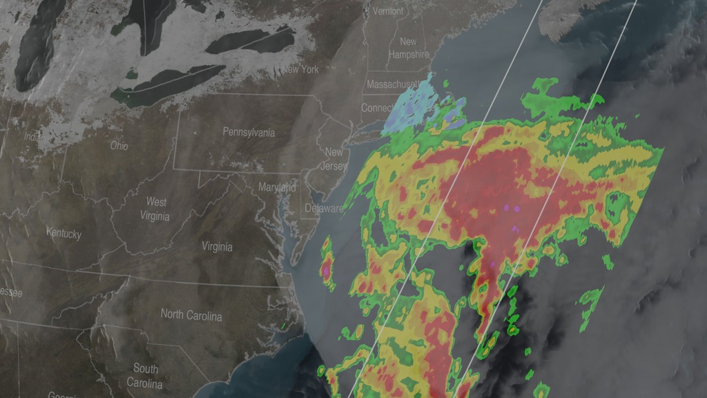
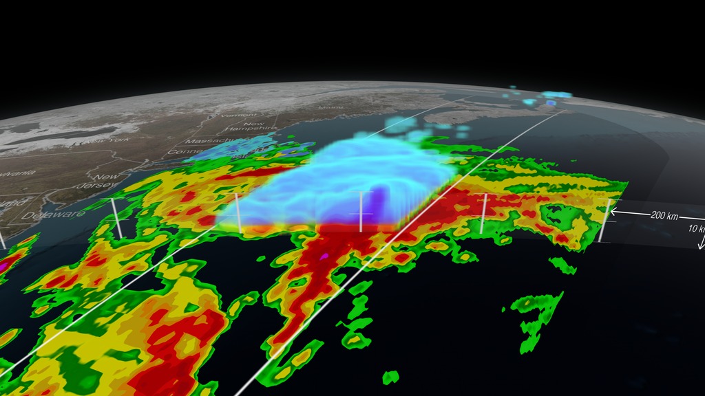
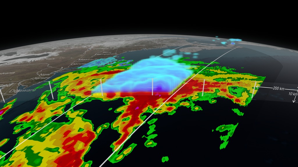
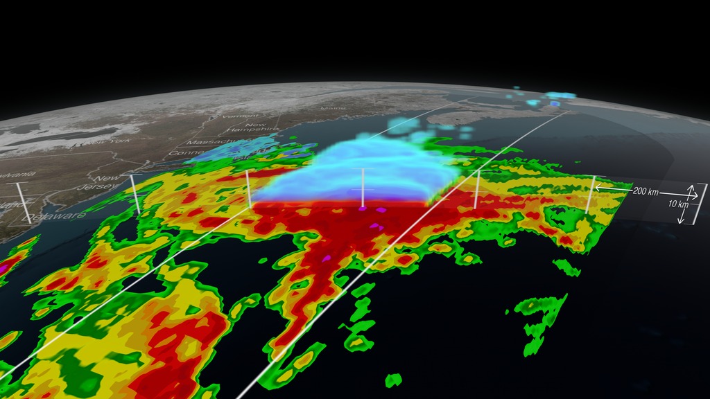
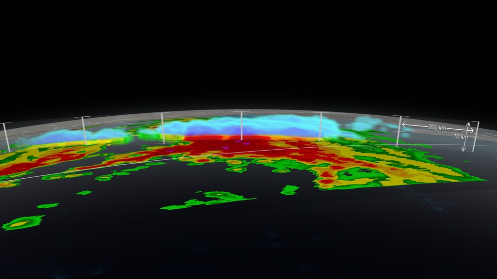
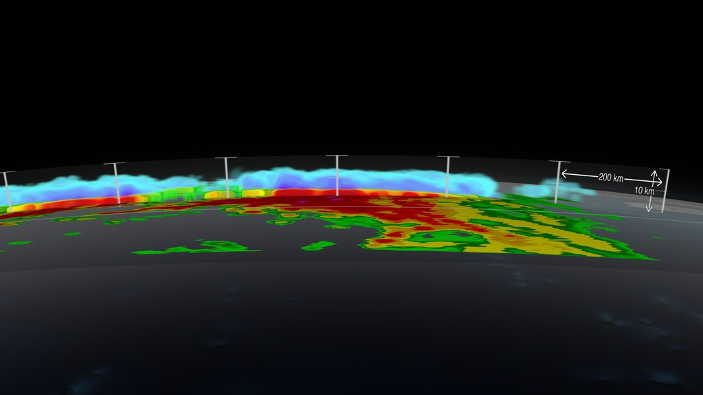
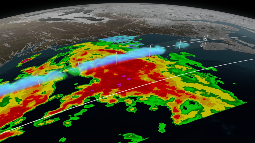
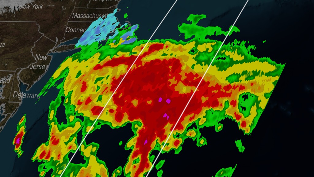
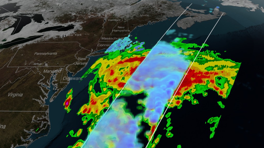
Nor'easters form when warm moist air traveling north with the Gulf Stream up the coast collides with cold air travelling down from Canada. The combination of moisture and cold can develop into snowstorms. In Jan. 2015, these air masses collided into a storm that brought blizzard conditions with, as of Tuesday morning, up to 30 inches of snow and 70 mile per hour winds across parts of Connecticut, Maine, Massachusetts, New Hampshire New York and Rhode Island. Lesser snow totals also hit New Jersey, Pennsylvania, Maryland, Virginia and West Virginia. Snow is expected to continue to fall into Wednesday as the storm moves northeast up the coast.
The GPM Core Observatory carries two instruments that show the location and intensity of rain and snow, which defines a crucial part of the storm structure – and how it will behave. The GPM Microwave Imager sees through the tops of clouds to observe how much and where precipitation occurs, and the Dual-frequency Precipitation Radar observes precise details of precipitation in 3-dimensions.
GPM data is part of the toolbox of satellite data used by forecasters and scientists to understand how storms behave. GPM is a joint mission between NASA and the Japan Aerospace Exploration Agency. Current and future data sets are available with free registration to users from NASA Goddard's Precipitation Processing Center website.


Related
Visualization Credits
Greg Shirah (NASA/GSFC): Animator
Ryan Fitzgibbons (USRA): Lead Producer
Rani Gran (NASA/GSFC): Producer
Gail Skofronick Jackson (NASA/GSFC): Lead Scientist
Dalia B Kirschbaum (NASA/GSFC): Lead Scientist
George Huffman (NASA/GSFC): Lead Scientist
Laurence Schuler (ADNET Systems, Inc.): Lead Project Support
Ian Jones (ADNET Systems, Inc.): Project Support
Ellen T. Gray (ADNET Systems, Inc.): Lead Writer
NASA's Scientific Visualization Studio
https://svs.gsfc.nasa.gov/4266
Mission:
Global Precipitation Measurement (GPM)
Data Used:
GOES/IR4
1/25/2015 20:45Z - 1/26/2015 22:15ZGPM/GMI/Surface Precipitation also referred to as: Rain Rates
1/26/2015 22:01:42Z - 22:06:40ZData provided by the joint NASA/JAXA GPM mission.
GPM/DPR/Ku also referred to as: Volumetric Precipitation data
Observed Data - JAXA - 1/26/2015 21:41:28Z - 22:11:27ZData provided by the joint NASA/JAXA GPM mission.
This item is part of this series:
GPM Animations
Keywords:
DLESE >> Atmospheric science
DLESE >> Cryology
SVS >> HDTV
DLESE >> Natural hazards
GCMD >> Earth Science >> Atmosphere >> Precipitation
GCMD >> Earth Science >> Atmosphere >> Atmospheric Phenomena >> Hurricanes
GCMD >> Earth Science >> Atmosphere >> Atmospheric Phenomena >> Storms
GCMD >> Earth Science >> Atmosphere >> Atmospheric Phenomena >> Typhoons
GCMD >> Earth Science >> Atmosphere >> Precipitation >> Precipitation Rate
SVS >> Hyperwall
NASA Science >> Earth
SVS >> Presentation
GCMD keywords can be found on the Internet with the following citation: Olsen, L.M., G. Major, K. Shein, J. Scialdone, S. Ritz, T. Stevens, M. Morahan, A. Aleman, R. Vogel, S. Leicester, H. Weir, M. Meaux, S. Grebas, C.Solomon, M. Holland, T. Northcutt, R. A. Restrepo, R. Bilodeau, 2013. NASA/Global Change Master Directory (GCMD) Earth Science Keywords. Version 8.0.0.0.0


