Earth
ID: 3472
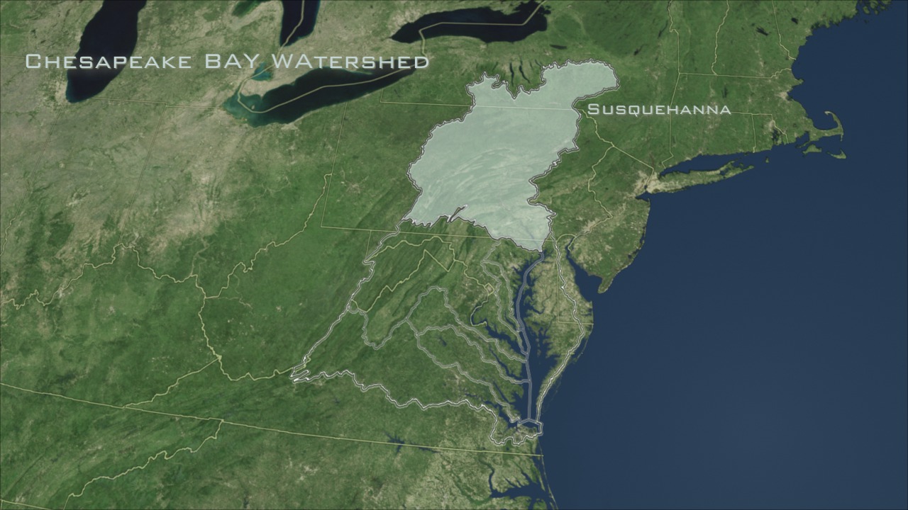
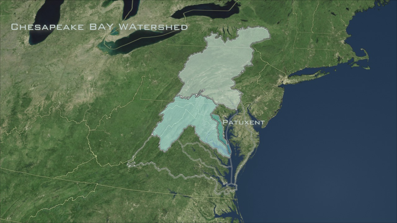
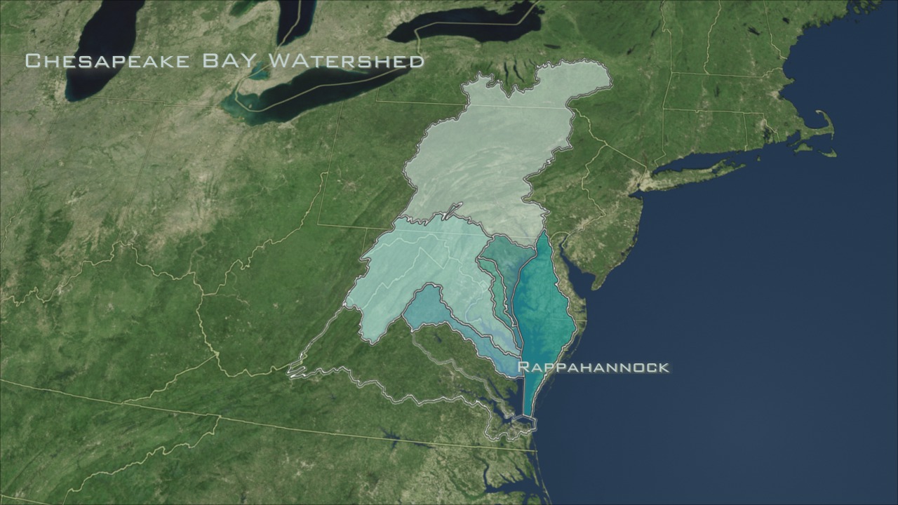
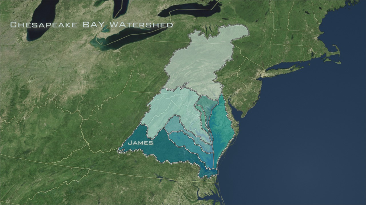
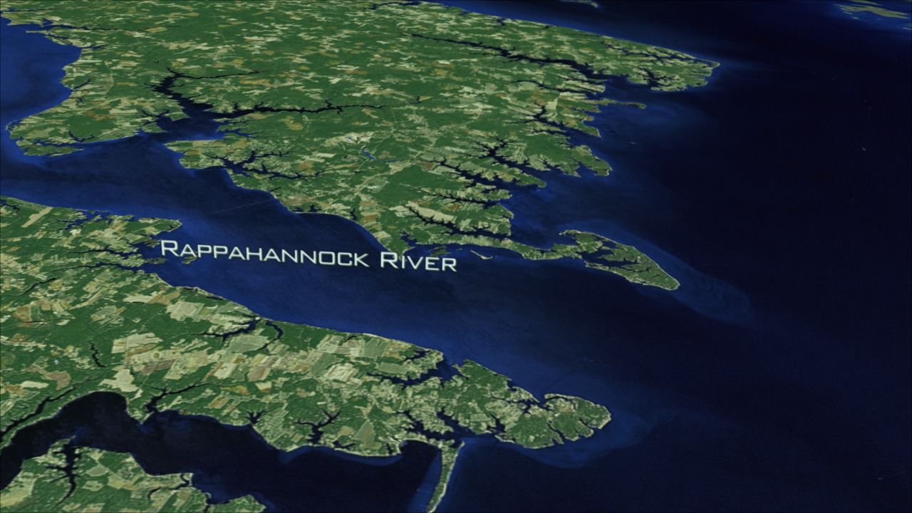
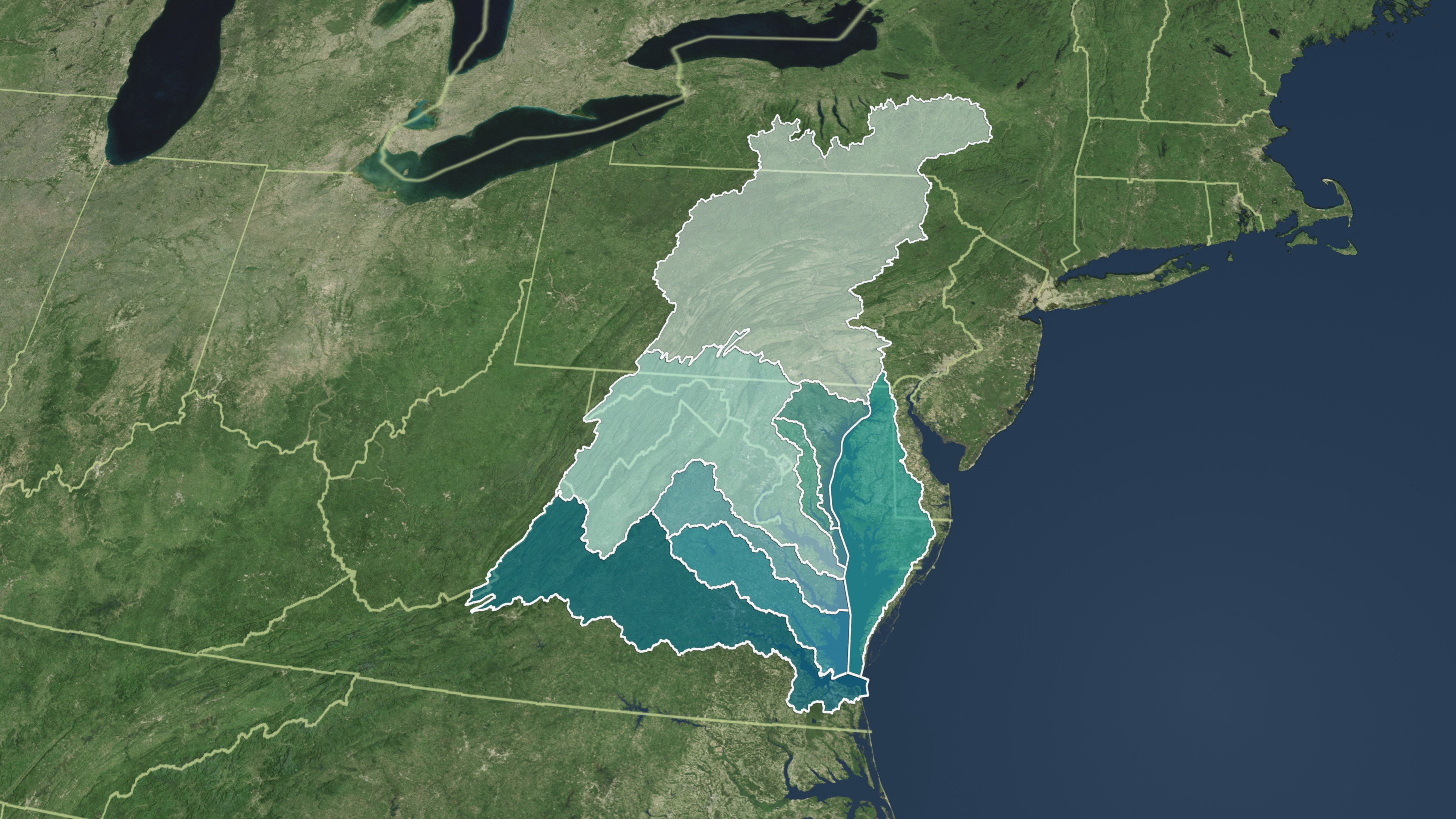
The watershed that drains into the Chesapeake Bay is a huge expanse that extends 64,000 miles into six states across North America (New York, Pensylvania, Maryland, Delaware, Virginia, and West Virginia) and the District of Columbia. This visualization overlays the full watershed onto a Landsat satellite visualization of the Bay area. The eight different distinctly colored regions indicate the Chesapeake's major subwatersheds. These subwatershed regions are: Susquehanna, Potomac, Patuxent, MD West Shore, Rapahhannock, Eastern Shore, James and York. This visualization is an extension of the Chesapeake Bay Flyover (#3446) in order to demonstrate the entire Chesapeake Bay Watershed region. The imagery utilized for this animation is a false-color Chesapeake Bay Landsat-7 Mosaic (#3473) composed of eight scenes acquired between 1999-2002, which were put together and color corrected to resemble natural looking colors.


Chesapeake Bay Flyover and Watershed Region
Data Notes:
The mosaic was created by EarthSat under contract with NASA as part of the GeoCover 2000 product. All images used in GeoCover were acquired by Landsat-7 during the period of 1999-2002. The pixel size of the full resolution image represents 14.25 m on the ground. The Chesapeake Bay mosaic uses portions of eight Landsat-7 scenes. Below you will find a listing of the eight Landsat 7 images that were put together to create the composite image. Landsat scenes are organized by a Path and Row number according to the Worldwide Reference System. (To learn more about Landsat's Worldwide Reference System, please visit: http://landsat.gsfc.nasa.gov/about/wrs.html)
Scenes used in the Chesapeake Bay mosaic:
- Landsat-7 WRS Path 15-Row 32 acquired on Oct. 05, 2001
- Landsat-7 WRS Path 14-Row 32 acquired on Sept. 23, 1999
- Landsat-7 WRS Path 15-Row 33 acquired on October 05, 2001
- Landsat-7 WRS Path 14-Row 33 acquired on July 10, 2001
- Landsat-7 WRS Path 15-Row 34 acquired on Sept. 30, 1999
- Landsat-7 WRS Path 14-Row 34 acquired on July 10, 2001
- Landsat-7 WRS Path 15-Row 35 acquired on Sept. 30, 1999
- Landsat-7 WRS Path 14-Row 35 acquired on Sept. 23, 1999
Related
Visualization Credits
Helen-Nicole Kostis (UMBC): Lead Animator
Cindy Starr (Global Science and Technology, Inc.): Visualizer
Jeff de La Beaujardiere (NASA): Animator
Greg Shirah (NASA/GSFC): Animator
Andrew Freeberg (NASA/GSFC): Producer
Darrel Williams (NASA/GSFC): Scientist
Laura Rocchio (SSAI): Scientist
Cindy Starr (Global Science and Technology, Inc.): Visualizer
Jeff de La Beaujardiere (NASA): Animator
Greg Shirah (NASA/GSFC): Animator
Andrew Freeberg (NASA/GSFC): Producer
Darrel Williams (NASA/GSFC): Scientist
Laura Rocchio (SSAI): Scientist
Please give credit for this item to:
NASA/Goddard Space Flight Center Scientific Visualization Studio
NASA/Goddard Space Flight Center Scientific Visualization Studio
Short URL to share this page:
https://svs.gsfc.nasa.gov/3472
Mission:
Landsat
Data Used:
Note: While we identify the data sets used in these visualizations, we do not store any further details nor the data sets themselves on our site.
This item is part of these series:
Landsat 7
Chesapeake Bay
Goddard TV Tapes:
G2008-034HD -- NASAs HD Chesapeake Bay Resource Tape
G2008-041HD -- NASAs Landsat in HD 2008 Resource Tape
Keywords:
SVS >> Chesapeake Bay
SVS >> Flyover
SVS >> HDTV
SVS >> Landsat
GCMD >> Earth Science
SVS >> Hyperwall
NASA Science >> Earth
NASA Earth Science Focus Areas >> Water and Energy Cycle
GCMD keywords can be found on the Internet with the following citation: Olsen, L.M., G. Major, K. Shein, J. Scialdone, S. Ritz, T. Stevens, M. Morahan, A. Aleman, R. Vogel, S. Leicester, H. Weir, M. Meaux, S. Grebas, C.Solomon, M. Holland, T. Northcutt, R. A. Restrepo, R. Bilodeau, 2013. NASA/Global Change Master Directory (GCMD) Earth Science Keywords. Version 8.0.0.0.0
https://svs.gsfc.nasa.gov/3472
Mission:
Landsat
Data Used:
Landsat-7/ETM+
1999-2002This item is part of these series:
Landsat 7
Chesapeake Bay
Goddard TV Tapes:
G2008-034HD -- NASAs HD Chesapeake Bay Resource Tape
G2008-041HD -- NASAs Landsat in HD 2008 Resource Tape
Keywords:
SVS >> Chesapeake Bay
SVS >> Flyover
SVS >> HDTV
SVS >> Landsat
GCMD >> Earth Science
SVS >> Hyperwall
NASA Science >> Earth
NASA Earth Science Focus Areas >> Water and Energy Cycle
GCMD keywords can be found on the Internet with the following citation: Olsen, L.M., G. Major, K. Shein, J. Scialdone, S. Ritz, T. Stevens, M. Morahan, A. Aleman, R. Vogel, S. Leicester, H. Weir, M. Meaux, S. Grebas, C.Solomon, M. Holland, T. Northcutt, R. A. Restrepo, R. Bilodeau, 2013. NASA/Global Change Master Directory (GCMD) Earth Science Keywords. Version 8.0.0.0.0


