Earth
ID: 12252
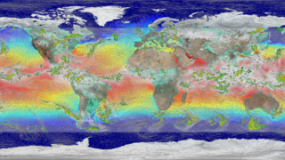
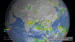
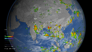
The monsoon is a seasonal rain and wind pattern that occurs over South Asia (among other places). Through NASA satellites and models we can see the monsoon patterns like never before. Monsoon rains provide important reservoirs of water that sustain human activities like agriculture and supports the natural environment through replenishment of aquifers. However, too much rainfall routinely causes disasters in the region, including flooding of the major rivers and landslides in areas of steep topography.
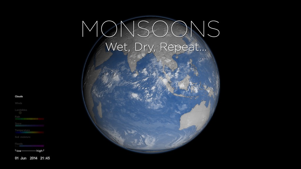
Monsoons: Wet, Dry, Repeat... Abridged Version
This visualization uses a combination of NASA satellite data and models to show how and why the monsoon develops over this region. In the summer the land gets hotter, heating the atmosphere and pulling in cooler, moisture-laden air from the oceans. This causes pulses in heavy rainfall throughout the region. In the winter the land cools off and winds move towards the warmer ocean and suppressing rainfall on land.
This is an abridged version of a longer narrated visualization.
Source Material
Alternate Versions
Credits
Ryan Fitzgibbons (USRA): Lead Producer
Greg Shirah (NASA/GSFC): Lead Visualizer
Horace Mitchell (NASA/GSFC): Lead Visualizer
Gail Skofronick Jackson (NASA/GSFC): Lead Scientist
Dalia B Kirschbaum (NASA/GSFC): Lead Scientist
George Huffman (NASA/GSFC): Lead Scientist
Trent L. Schindler (USRA): Visualizer
Lori Perkins (NASA/GSFC): Visualizer
George Huffman (NASA/GSFC): Lead Narrator
Gail Skofronick Jackson (NASA/GSFC): Lead Narrator
Please give credit for this item to:
NASA's Goddard Space Flight Center
NASA's Goddard Space Flight Center
Short URL to share this page:
https://svs.gsfc.nasa.gov/12252
Missions:
Global Precipitation Measurement (GPM)
Soil Moisture Active Passive (SMAP)
Data Used:
Note: While we identify the data sets used in these visualizations, we do not store any further details nor the data sets themselves on our site.
This item is part of this series:
Narrated Movies
Keywords:
SVS >> HDTV
GCMD >> Earth Science >> Atmosphere >> Precipitation
GCMD >> Earth Science >> Atmosphere >> Atmospheric Phenomena >> Monsoons
GCMD >> Earth Science >> Atmosphere >> Precipitation >> Rain
NASA Science >> Earth
GCMD keywords can be found on the Internet with the following citation: Olsen, L.M., G. Major, K. Shein, J. Scialdone, S. Ritz, T. Stevens, M. Morahan, A. Aleman, R. Vogel, S. Leicester, H. Weir, M. Meaux, S. Grebas, C.Solomon, M. Holland, T. Northcutt, R. A. Restrepo, R. Bilodeau, 2013. NASA/Global Change Master Directory (GCMD) Earth Science Keywords. Version 8.0.0.0.0
https://svs.gsfc.nasa.gov/12252
Missions:
Global Precipitation Measurement (GPM)
Soil Moisture Active Passive (SMAP)
Data Used:
GEMS/Soil Moisture
Model - NASA NSIPP
GEMS stands for Goddard Earth Modeling System. It is also known as the NSIPP Global Climate Model.
CPC (Climate Prediction Center) Cloud Composite
Data Compilation - Climate Prediction Center (CPC) - 2014-2015
Global cloud cover from multiple satellites
MERRA
Analysis - 2014-2015also referred to as: IMERG
Data Compilation - NASA/GSFCalso referred to as: Global Flood Monitoring System (GFMS)
Model - UMD - 2014-2015This item is part of this series:
Narrated Movies
Keywords:
SVS >> HDTV
GCMD >> Earth Science >> Atmosphere >> Precipitation
GCMD >> Earth Science >> Atmosphere >> Atmospheric Phenomena >> Monsoons
GCMD >> Earth Science >> Atmosphere >> Precipitation >> Rain
NASA Science >> Earth
GCMD keywords can be found on the Internet with the following citation: Olsen, L.M., G. Major, K. Shein, J. Scialdone, S. Ritz, T. Stevens, M. Morahan, A. Aleman, R. Vogel, S. Leicester, H. Weir, M. Meaux, S. Grebas, C.Solomon, M. Holland, T. Northcutt, R. A. Restrepo, R. Bilodeau, 2013. NASA/Global Change Master Directory (GCMD) Earth Science Keywords. Version 8.0.0.0.0


