Hurricane Jose lingers in the Atlantic as Hurricane Maria approaches Puerto Rico
GPM passed over both Hurricane Maria and Hurricane Jose on September 18th, 2017. As the camera moves in on the Maria, DPR's volumetric view of the storm is revealed. A slicing plane moves across the volume to display precipitation rates throughout the storm. Shades of green to red represent liquid precipitation extending down to the ground.
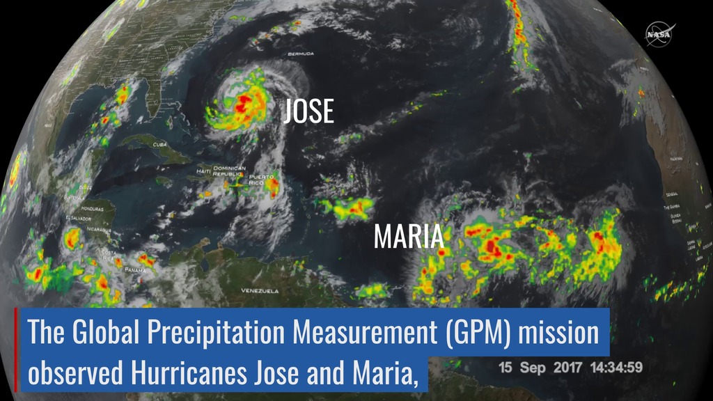
The Global Precipitation Measurement (GPM) mission shows the rainfall distribution for two major storms churning in the Atlantic and Caribbean basins. The visualization shows Hurricane Jose as it continues to slowly move northward off the US East Coast east of the Outer Banks of North Carolina. At one time, Jose was a powerful category 4 border line category 5 storm with maximum sustained winds reported at 155 mph by the National Hurricane Center back on the 9th of September as it was approaching the northern Leeward Islands. Jose passed northeast of the Leeward Islands as a category 4 storm on a northwest track and then began to weaken due to the effects of northerly wind shear. Remaining over warm water allowed Jose to strengthen back into a hurricane on September 15th as wind shear across the storm diminished. At this time, Jose was still only midway between the central Bahamas and Bermuda, having just completed its loop, and moving to the northwest. On the 16th, Jose turned northward as it moved around the western edge of a ridge of high pressure near Bermuda and began to parallel the US East Coast well away from shore. An overpass by the GPM Core Observatory captured an image of Jose overnight at 3:36 UTC 18 September (11:36 pm EST 17 September) as the storm was moving due north at 9 mph well off shore from the coast of North Carolina. The GPM image estimated areas of very heavy rain on the order of 75 mm/hr (~3 inches per hour).
The GPM Core Observatory satellite also had an excellent view of Hurricane Maria when it passed almost directly above the hurricane on September 17, 2017 at 1001 PM AST (September 18, 2017 0201 UTC). GPM's Microwave Imager (GMI) and Dual-Frequency Precipitation Radar (DPR) showed that Maria had well defined bands of precipitation rotating around the eye of the tropical cyclone. GPM's radar (DPR Ku band) found rain falling at a rate of over 6.44 inches (163.7 mm) per hour in one of these extremely powerful storms northeast of Maria's eye. Intense thunderstorms were found towering to above 9.7 miles (15.7 km). This kind of chimney cloud is also called a "hot tower" (as it releases a huge quantity of latent heat by condensation). These tall thunderstorms in the eye wall are often a sign that a tropical cyclone is becoming more powerful. Maria rapidly intensified following this view to a Category 5 storm on September 19th.
. Shades of green represent low amounts of liquid precipitation, whereas shades of red represent high amounts of precipitation.")
Color bar for liquid precipitation rates (ie, rain rates). Shades of green represent low amounts of liquid precipitation, whereas shades of red represent high amounts of precipitation.
Color bar for frozen precipitation rates (ie, snow rates). Shades of cyan represent low amounts of frozen precipitation, whereas shades of purple represent high amounts of precipitation.
Print resolution still image of Hurricane Maria on September 18th, 2017.
Print resolution still image of Hurricane Maria on September 18th, 2017.
Print resolution still image of Hurricane Maria on September 18th, 2017.
Print resolution still image of Hurricane Maria and Hurricane Jose on September 18th, 2017.
Credits
Please give credit for this item to:
NASA's Scientific Visualization Studio
-
Visualizers
-
Kel Elkins
(USRA)

-
Alex Kekesi
(Global Science and Technology, Inc.)
- Horace Mitchell (NASA/GSFC)
-
Kel Elkins
(USRA)
-
Producer
- Ryan Fitzgibbons (USRA)
-
Scientists
- Gail Skofronick Jackson (NASA/GSFC)
-
George Huffman
(NASA/GSFC)
- Dalia B Kirschbaum (NASA/GSFC)
Missions
This page is related to the following missions:Series
This page can be found in the following series:Datasets used
-
[GOES: IR4]
ID: 33 -
Rain Rates (Surface Precipitation) [GPM: GMI]
ID: 822Credit: Data provided by the joint NASA/JAXA GPM mission.
See all pages that use this dataset -
Volumetric Precipitation data (Ku) [GPM: DPR]
ID: 830Credit: Data provided by the joint NASA/JAXA GPM mission.
See all pages that use this dataset -
IMERG
ID: 863This dataset can be found at: http://pmm.nasa.gov/sites/default/files/document_files/IMERG_ATBD_V4.4.pdf
See all pages that use this dataset
Note: While we identify the data sets used on this page, we do not store any further details, nor the data sets themselves on our site.
Used as a Source In
- ID: 13216
![Complete transcript available.Music credits: “Northern Breeze” by Denis Levaillant [SACEM], “Stunning Horizon” by Maxime Lebidois [SACEM], Ronan Maillard [SACEM], “Magnetic Force” by JC Lemay [SACEM] from Killer TracksWatch this video on the NASA Goddard YouTube channel.This video can be freely shared and downloaded. While the video in its entirety can be shared without permission, some individual imagery provided by pond5.com is obtained through permission and may not be excised or remixed in other products. Specific details on stock footage may be found here. For more information on NASA’s media guidelines, visit https://www.nasa.gov/multimedia/guidelines/index.html.Notes on footage:• 0:03 - 0:17 provided by Pond5• 1:38 - 1.43 provided by Pond5• 1:49 - 1:52 provided by Pond5• 2:21 - 1:27 provided by Pond5](/vis/a010000/a013200/a013216/13216_NASA_Has_Eyes_On_The_Atlantic_Hurricane_Season_YouTube.00050_print.jpg) Produced Video
Produced Video - ID: 12738
![Watch this video on the NASA Goddard YouTube channel.Complete transcript available.Music credits: 'Micro Currents' by Jean-Patrick Voindrot [SACEM], 'Sink Deep' by Andrew Michael Britton [PRS], David Stephen Goldsmith [PRS], Mikey Rowe [PRS] from Killer Tracks.](/vis/a010000/a012700/a012738/LARGE_MP4-12738_RapidIntensification_large.00084_print.jpg) Produced Video
Produced Video - ID: 12723
 Produced Video
Release date
This page was originally published on Tuesday, September 19, 2017.
This page was last updated on Sunday, January 5, 2025 at 11:22 PM EST.