Zooming In: Remote Sensing the Earth
This gallery was created for Earth Science Week 2015 and beyond. It includes a quick start guide for educators and first-hand stories (blogs) for learners of all ages by NASA visualizers, scientists and educators. We hope that your understanding and use of NASA's visualizations will only increase as your appreciation grows for the beauty of the science they portray, and the communicative power they hold. Read all the blogs and find educational resources for all ages at: the Earth Science Week 2015 page.
Observing something without coming in contact with it is called remote sensing. Think about that. Every living animal uses remote sensing. A spider keeps its eight eyes fixed on a fly, watches its movements. A dolphin sends out sounds to locate a school of fish. A tiger uses its Jacobson's organ to smell a mate. Humans listen to cicadas' loud noises coming from the trees. These are all examples of remote sensing. And, more than likely, all of these animals are analyzing the data they are receiving. I used these particular examples to show that there are different methods of receiving this data. The spider uses sight. The dolphin uses echolocation. The tiger uses smell. The human uses sound.
I remember the first time I flew in an airplane. I was about 12 years old and was lucky enough to get a window seat. It was amazing to look down and try to identify things on the ground. I didn't realize it at the time but I was remotely sensing Earth! I could almost imagine how a bird must see the land when it's flying high in the sky. Since I cannot fly all the time like birds do, I can use another tool — Google Earth — to get the same experience. I can look at my computer screen, and identify the differences between urban and natural areas and between fields and forests.
NASA creates the most amazing remotely-sensed images of space and the planets. I have always been fascinated by space and space exploration. In 1969, as I listened on my radio to the broadcast of the moon landing, I wondered what it would be like to walk on the moon and to look further out into space. Now, space telescopes, such as Hubble, provide scientists with hundreds of thousands of images for understanding our universe.
Images of outer space are fascinating, but I am most excited about images of Earth. NASA and the U.S. Geological Survey have created an amazing collection of satellite images, called Earth as Art. Sometimes these almost look like art from a museum. These images are not only pleasing to look at; they can also tell us valuable information.
")
Ganges River Delta, taken by Landsat-7 on January 1, 1999. The Landsat mission is a partnership between the USGS and NASA. (Source: USGS EROS Data Center)
Scientists analyze remotely sensed images and data to understand our Earth. They use these images to study types of vegetation and the health of that vegetation. They analyze the effects of flooding or drought, cloud formations, or even environmental disasters. And, over time, they can look for changes in the environment.
Zooming in on one of these images will show that they are made up of many small squares called pixels. Each pixel represents the smallest area the satellite instrument can view. For example, one satellite called Landsat produces a pixel that is 30 meters by 30 meters. Different satellites have different pixel resolution.
NASA, sometimes partnering with other country's space agencies, has launched many satellites that provide important scientific data. These satellites carry different instruments that provide data on different Earth features. For example, the CALIPSO satellite detects natural and human-produced aerosols and thin clouds; CloudSat, detects the vertical structure of clouds, GPM, measures precipitation, and the SMAP satellite, detects soil moisture in the top five centimeters of soil. Students involved in The GLOBE Program can collaborate with these remote sensing missions by collecting data near their schools. Scientists need data collected on the ground to know that the satellite's instruments traveling high above are collecting data accurately.
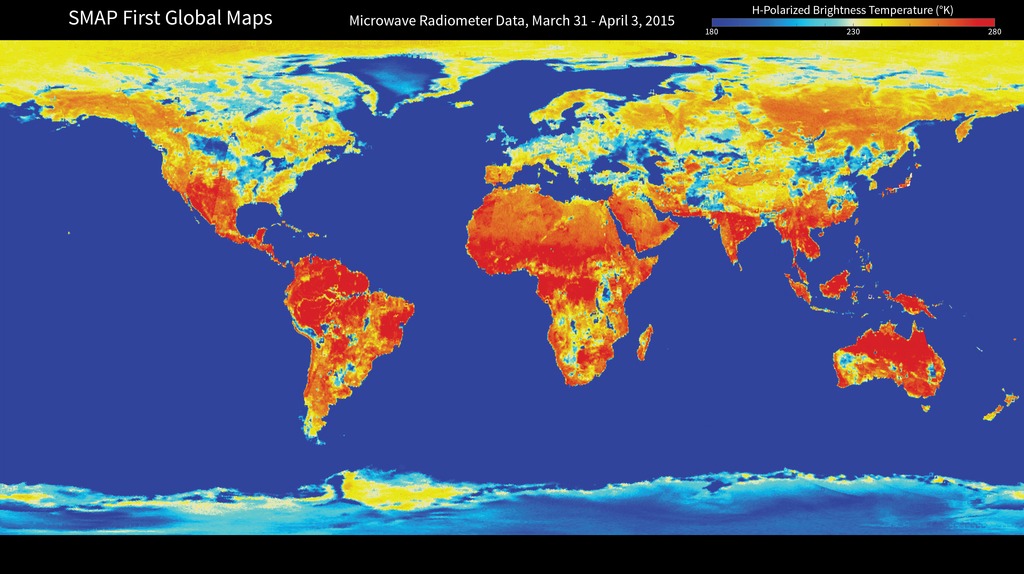
 mission. The SMAP mission produces high-resolution maps of global soil moisture and detects whether soils are frozen or thawed. For more information on this map, click here.")
This is one of the first maps that has been prepared using data from NASA's Soil Moisture Active Passive (SMAP) mission. The SMAP mission produces high-resolution maps of global soil moisture and detects whether soils are frozen or thawed.
For more information on this map, click here.
We sense our environment remotely all the time, either with our senses or with scientific instruments. You're probably doing it right now; either reading these words on a piece of paper or on a computer screen or perhaps someone is reading them to you. Sometimes it's a passive activity, like watching a spider spin its web; other times it can be quite an active activity, such as deciphering an image sent from a satellite millions of kilometers from Earth. Either way, it can be fascinating.
-- Gary Randolph, Training Coordinator at The GLOBE Implementation Office
, serving as a docent at the Columbus Zoo. Gary raised three bobcats for educational programs while with ISEC. He enjoys SCUBA diving and nature photography.")
Gary is the Training Coordinator at the GLOBE Implementation Office. He began working with GLOBE in late 1994 while serving as a Peace Corps Volunteer in the Czech Republic. In 1996 he took a position at the GLOBE Program Office in Washington, D.C. and relocated to Boulder, CO in 2003. Prior to the Peace Corps, Gary worked for the International Society for Endangered Cats (ISEC), serving as a docent at the Columbus Zoo. Gary raised three bobcats for educational programs while with ISEC. He enjoys SCUBA diving and nature photography.
For More Information
Credits
Please give credit for this item to:
NASA's Scientific Visualization Studio
-
Author
- Gary Randolph (GLOBE)
-
Project support
- Leann Johnson (Global Science and Technology, Inc.)
Related
- ID: 30596
 Hyperwall Visual
Release date
This page was originally published on Friday, October 9, 2015.
This page was last updated on Thursday, October 10, 2024 at 12:06 AM EDT.