2017 Eclipse Shadow Cones
- Visualizations by:
- Ernie Wright
- View full credits
Movies
- shadow_cones_720p30.mp4 (1280x720) [6.9 MB]
- shadow_cones_720p30.webm (1280x720) [5.6 MB]
- shadow_cones_720p30.wmv (1280x720) [17.9 MB]
- shadow_cones_1080p30.mp4 (1920x1080) [13.9 MB]
- shadow_cones_360p30.mp4 (640x360) [2.3 MB]
Images
- cones.0885_print.jpg (1024x576) [79.2 KB]
- cones.0885_thm.png (80x40) [4.1 KB]
- cones.0885_searchweb.png (320x180) [46.7 KB]
Frames
- frames/1920x1080_16x9_30p/ (1920x1080) [48.0 KB]
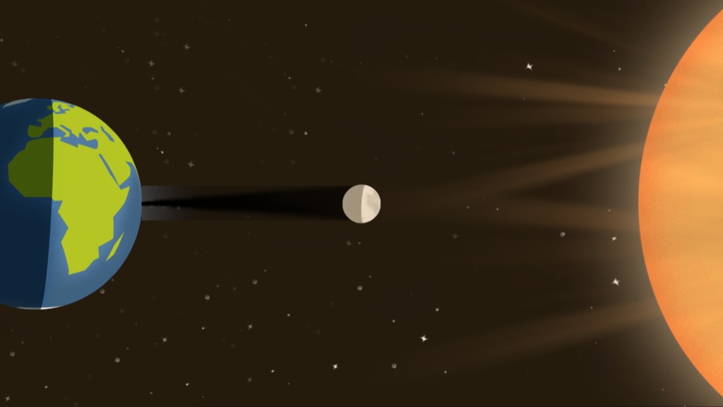
The umbral and penumbral shadow cones travel across the surface of the Earth during the August 21, 2017 total solar eclipse.
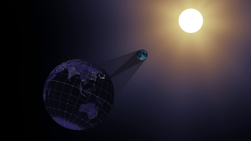
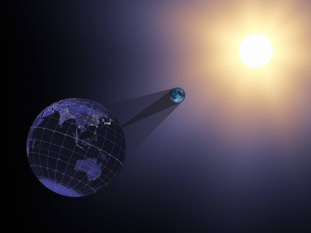
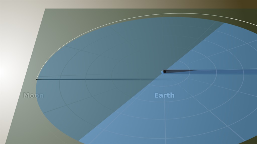
In this animation, the umbra and penumbra cones are viewed through a telescopic lens on a virtual camera located far behind the Moon. Long focal lengths like the one used here appear to compress the distance between near and far objects. Despite appearances, the geometry of the scene is correct. The Earth is roughly 112 lunar diameters beyond the Moon, and the angle at the apex of the umbral cone is only about half a degree.
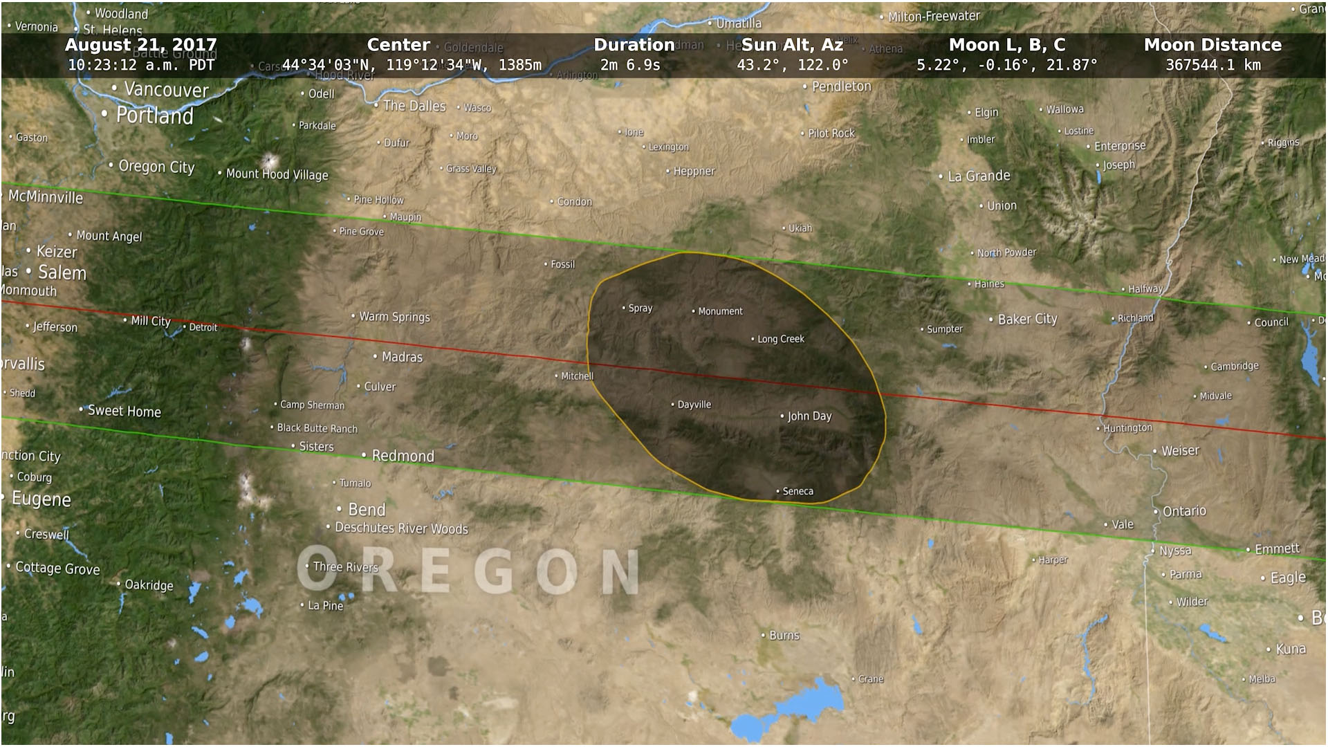
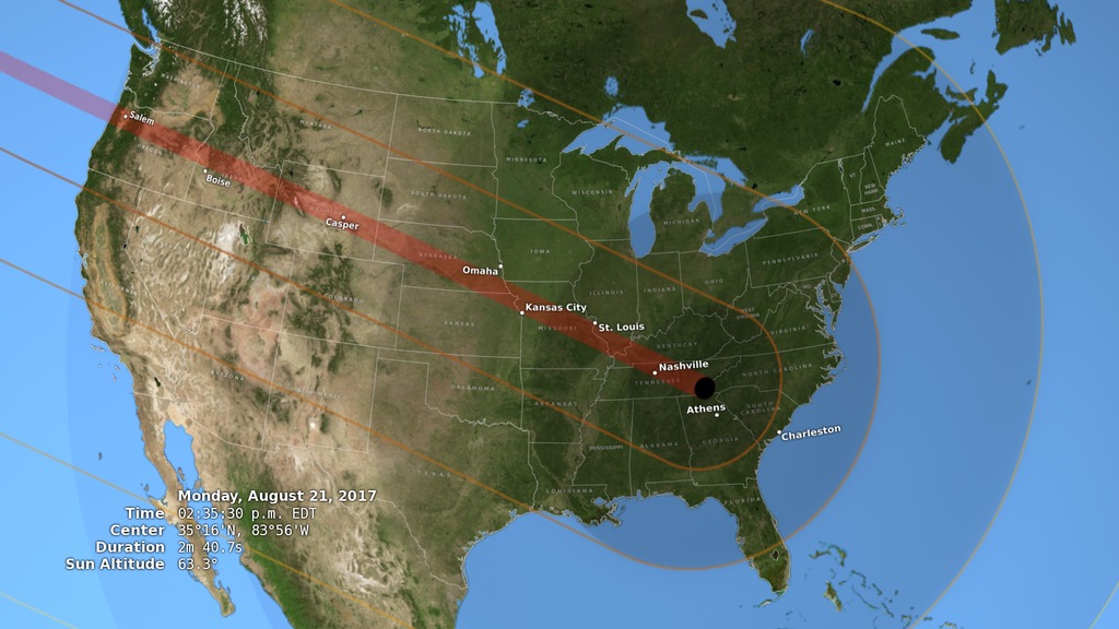
From this point of view directly behind the Moon, the edges of the shadow cones look circular. The edge of the penumbra is outlined in yellow. It passes over all of North and Central America and the Amazon basin, as well as Greenland and the North Pole. Everyone there will see at least a partial eclipse. The path of the umbra (the small black dot) crosses the United States from Oregon to South Carolina.
Credits
Please give credit for this item to:
NASA's Scientific Visualization Studio
Visualizer
- Ernie Wright (USRA) [Lead]
Producer
- Genna Duberstein (ADNET)
Series
This visualization can be found in the following series:Datasets used in this visualization
Terra and Aqua BMNG (A.K.A. Blue Marble: Next Generation) (Collected with the MODIS sensor)
Credit: The Blue Marble data is courtesy of Reto Stockli (NASA/GSFC).
Dataset can be found at: http://earthobservatory.nasa.gov/Newsroom/BlueMarble/
See more visualizations using this data setLRO DEM (A.K.A. Digital Elevation Map) (Collected with the LOLA sensor)
DE421 (A.K.A. JPL DE421)
Planetary ephemerides
Dataset can be found at: http://ssd.jpl.nasa.gov/?ephemerides#planets
See more visualizations using this data setLRO WAC 643nm High Sun Global Mosaic (Collected with the LROC sensor)
Note: While we identify the data sets used in these visualizations, we do not store any further details nor the data sets themselves on our site.
Related pages
The Moon's Role in a Solar Eclipse
July 21st, 2017
Read moreThis video explains how our moon creates a solar eclipse, why it's such a rare event to see, and how data from NASA's Lunar Reconnaissance Orbiter has enhanced our ability to map an eclipse's path of totality.Music Provided by Universal Production Music: “Bring Me Up” – Anders Gunnar Kampe & Henrik Lars Wikstrom.Watch this video on the NASA.gov Video YouTube channel. While the sun is the main focus of a solar eclipse, our moon plays the most crucial role in creating this unique event. This video tutorial explains what happens during a total solar eclipse and a partial eclipse and how often they both occur. The video also explains how a solar eclipse differs from a lunar eclipse, and gives a helpful tip on how to remember the difference. In addition, the video examines how the two parts of the moon’s shadow, the umbra and penumbra, affect how we see an eclipse on the Earth, and illustrates the surprising true shape of the umbra. The video concludes by highlighting how data from NASA’s Lunar Reconnaissance Orbiter has helped us better map a solar eclipse’s path of totality. Visualizations included in this piece showcase the August 21, 2017 total solar eclipse happening in the United States. Related pages
Flying Around The Eclipse Shadow
June 21st, 2017
Read moreA view of the Moon's shadow during the August 21, 2017 eclipse from both the night and day sides of the Earth. This visualization combines the views from several previous visualizations (#4390, #4321, and #4314) to create a continuous camera flight from the night side of the Earth to the day side, showing the relationship of the Earth, Moon, and Sun during the August 21, 2017 eclipse. It shows the direction of the Moon's motion and the Earth's rotation, the complete path of the umbra from the moment it touches down on the Earth until the moment it departs, and the true scale of the Earth-Moon system. For More InformationSee [eclipse2017.nasa.gov](eclipse2017.nasa.gov) Related pages
What determines when we have an eclipse?
June 13th, 2017
Read moreMusic: Witch Waltz by Dorian KellyComplete transcript available.Watch this video on the NASA Goddard YouTube channel. Animation without text Why are eclipses rare? The moon's orbit is tilted. Sometimes the moon's shadow is too high above the Earth. Sometimes it is too low. Other times, it is just right. Related pages
Rare Total Solar Eclipse Is Only Two Months Away Live Shots 6.21.17
June 13th, 2017
Read moreB-roll for the live shots Canned interview with NASA Scientist Dr. Nicholeen Viall looking off camera. Soundbites are separated by slates. Includes transcript of soundbites. Canned interview in Spanish with Dr. Yari Collado-Vega. Soundbites are separated with slates Soundbites with Drs. Alex Young and Noah Petro. TRT 5:41. Includes full transcript with timecodes The Countdown is on for Rare Solar Eclipse Visible Across all of North AmericaFor the First Time in Nearly 100 Years, Millions of Americans Coast-to-Coast Will see an Eclipse Chat with NASA to find out how you can catch this spectacular eventOn August 21, 2017, daylight will fade to the level of a moonlit night as millions of Americans experience one of nature’s most awe-inspiring shows – a total solar eclipse. For the first time since 1918, the dark shadow of the moon will sweep coast-to-coast across the United States, putting 14 states in the path of totality and providing a spectacular view of a partial eclipse across all 50 states.NASA scientists are available Wednesday, June 21, from 6:00 a.m. – 12:00 p.m. ET to show your viewers the path of the eclipse, what they need to see it safely and talk about the unprecedented science that will be gathered from one of the most anticipated and widely observed celestial events in history. We’ll also give your viewers a sneak peek of a press conference about the eclipse NASA is having later that day.A solar eclipse happens when a rare alignment of the sun and moon casts a shadow on Earth. NASA knows the shape of the moon better than any other planetary body, and this data allows us to accurately predict the shape of the shadow as it falls on the face of Earth. While everyone in the U.S. will see the eclipse if their local skies are clear, people standing in the path of totality – completely in the moon’s shadow – will see stars and planets become visible in what is normally a sunlit sky. Eclipses provide an unprecedented opportunity for us to see the sun’s faint outer atmosphere in a way that cannot be replicated by current human-made instruments. Scientists believe this region of the sun is the main driver for the sun’s constant outpouring of radiation, known as the solar wind, as well as powerful bursts of solar material that can be harmful to our satellites, orbiting astronauts and power grids on the ground. HD Satellite Coordinates for G17-K18/LO: Galaxy 17 Ku-band Xp 18 Slot Lower | 91.0 ° W Longitude | DL 12051.0 MHz | Vertical Polarity | QPSK/DVB-S | FEC 3/4 | SR 13.235 Mbps | DR 18.2954 MHz | HD 720p | Format MPEG2 | Chroma Level 4:2:0 | Audio Embedded**To book a window contact** / Michelle Handleman / michelle.z.handleman@nasa.gov / 301-286-0918Suggested Questions:1. This is the first time in nearly 100 years that the United States will have the opportunity to see a total solar eclipse coast-to-coast! What will happen on August 21?2. This eclipse will be the most widely observed and shared celestial event in U.S. history. Why are scientists excited for this eclipse?3. Eclipses allow scientists to see the sun’s faint outer atmosphere, which is actually hotter than its surface. What can you tell us about NASA’s upcoming mission that will touch the sun?4. How does NASA’s study of our sun help us explore the solar system?5. How does NASA’s mapping of the moon give us the accurate path of totality?6. Where can we learn more?Live Shot Details:Location: NASA’s Goddard Space Flight Center/Greenbelt, MarylandScientists:Dr. Alex Young / NASA ScientistDr. Nicholeen Viall / NASA ScientistDr. Noah Petro / NASA ScientistDr. Geronimo Villanueva [in Spanish] / NASA ScientistTo learn more visit:Eclipse Across AmericaOn Twitter @NASASun For More InformationSee [https://eclipse2017.nasa.gov/](https://eclipse2017.nasa.gov/) Related pages
Tracing the 2017 Solar Eclipse
Dec. 14th, 2016
Read moreHear data visualizer Ernie Wright discuss the map in the video above. To see the maps unedited, watch the two videos below.Music credit: Life Choices by Eric ChevalierComplete transcript available.Watch this video on the NASA Goddard YouTube channel. This animation closely follows the Moon's umbra shadow as it passes over the United States during the August 21, 2017 total solar eclipse. Through the use of a number of NASA datasets, notably the global elevation maps from Lunar Reconnaissance Orbiter, the shape and location of the shadow is depicted with unprecedented accuracy. When depicting an eclipse path, data visualizers have usually chosen to represent the moon's shadow as an oval. By bringing in a variety of NASA data sets, visualizer Ernie Wright has created a new and more accurate representation of the eclipse. For the first time, we are able to see that the moon's shadow is better represented as a polygon. This more complicated shape is based NASA's Lunar Reconnaissance Orbiter's view of the mountains and valleys that form the moon's jagged edge. By combining moon's terrain, heights of land forms on Earth, and the angle of the sun, Wright is able to show the eclipse path with the greatest accuracy to date. The 2017 Path of Totality Read more about this map The 2017 Path of Totality: Oblique View Read more about this map Related pages
Insolation during the 2017 Eclipse
May 22nd, 2016
Read moreInsolation (the amount of sunlight reaching the ground) is affected dramatically by the Moon's shadow during the August 21, 2017 total solar eclipse. The color key for the insolation map. A map-like view of the Earth shows insolation (sunlight intensity) over land during the August 21, 2017 total solar eclipse. This equirectangular projection is suitable for spherical displays and for spherical mapping in 3D animation software. The obscuration dataset used to calculate insolation. Obscuration, the fraction of the Sun's area covered by the Moon, is calculated at 10-second intervals from 16:25:40 to 20:25:30 UTC at a resolution of 360/8192 degrees per pixel (roughly 3.75 × 4.9 km at 40°N). The maps are global equirectangular projections centered on (0°, 0°), with white = 100% obscuration and black = 0%. The sharp borders are the terminator (the day-night line). The complete dataset can be downloaded as a single .zip file (196 MB). On an ordinary day, the insolation — the amount of sunlight hitting a given spot on the Earth — is proportional to the sine of the Sun's altitude. When the Sun is 30° above the horizon, the sunlight energy per square meter is half of what it is when the Sun is directly overhead. This relationship is the reason that the tropics are hot and the poles are cold. Combined with day length, it's also the reason for the difference in temperature between the seasons at temperate latitudes.As this animation shows, the Moon's shadow dramatically, if temporarily, affects insolation in the continental United States during the total solar eclipse of August 21, 2017. The effect is readily apparent to observers in the path of totality. As the umbra passes overhead, the temperature drops by several degrees. The cooled column of air within the shadow cone can even influence cloud formation and the speed and direction of the wind.The insolation map in the animation combines solar altitude with obscuration, the fraction of the Sun's area blocked by the Moon during the eclipse. It ignores a number of other factors, including atmospheric scattering, refraction, and cloud cover, that also play a role in the amount of sunlight that reaches the ground. Related pages
2017 Solar Eclipse from L1
May 22nd, 2016
Read moreThe August 21, 2017 total solar eclipse as seen from a satellite in orbit around L1, a point about 1.5 million kilometers from Earth in the direction of the Sun. A number of satellites will be watching the August 21, 2017 total solar eclipse from space. One of them, the Deep Space Climate Observatory (DSCOVR) will see the eclipse from its orbit around L1, the Lagrange point located about 1.5 million kilometers from Earth along the Earth-Sun line. From this vantage point, DSCOVR's EPIC camera continuously images the full sunlit disk of the Earth.This animation simulates the view that EPIC will have of the 2017 eclipse. The shadow size and opacity are based on the eclipse obscuration, the fraction of the Sun's disk covered by the Moon. The bright spot near the equator is the reflection of the Sun on the water. The red streak shows the path of totality, the locations on the Earth where observers will see the Sun completely covered by the Moon.EPIC will see both the Moon's shadow and the Sun's reflection because DSCOVR's orbit takes it several degrees off both the Sun-Earth line and the Sun-Moon line. For the same reason, the Moon will not be in the frame. The animation places the virtual camera in a plausible position for DSCOVR. The actual position of the spacecraft at the time of the eclipse will be affected by adjustments to its orbit that may be made in the coming months.EPIC has already captured the total solar eclipse of March, 2016. Related pages
NASA On Air: NASA Previews 2017 Total Solar Eclipse (11/11/2015)
Nov. 11th, 2015
Read moreLEAD: NASA scientists and astronomers are already planning for the first total solar eclipse for the United States in 38 years. 1. On August 21, 2017, the moon will pass between the sun and Earth in an alignment that will cast the moon's shadow onto Earth. 2. A dark shadow of the moon, 170 miles wide, will sweep across the U.S. over the course of one-and-a-half hours. 3. People in cities lying within the narrow path of the shadow (red line in the video) will experience an eerie sense of twilight as day turns to night and back to day again within roughly 2-2.5 minutes. TAG: Solar astronomers will use the solar eclipse to study the outer atmosphere of the sun. Related pages
2017 Eclipse: Earth, Moon and Sun
Oct. 19th, 2015
Read moreThe Moon moves right to left in its orbit around the Earth. The shadow it casts hits the Earth during the August 21, 2017 total solar eclipse. A print-resolution still image showing the Earth, Moon, and Sun at 17:05:40 UTC during the August 21, 2017 eclipse. The image is 12 × 9 inches at 300 DPI. A solar eclipse occurs when the Moon passes between the Sun and the Earth, casting its shadow on the Earth. The shadow comprises two concentric cones called the umbra and the penumbra. Observers on the Earth who are within the smaller, central umbra see the Sun completely blocked. Within the larger penumbra, the Sun is only partially blocked.In this animation, the Earth, Moon, Sun, and shadow cones are viewed through a telescopic lens on a virtual camera located far behind the Earth. Long focal lengths like the one used here appear to compress the distance between near and far objects. Despite appearances, the geometry of the scene is correct. The Moon's umbra cone is roughly 30 Earth diameters long, barely enough to reach the Earth, while the Sun is almost 400 times farther away.From this perspective, we see the night sides of both the Earth and the Moon. Solar eclipses can only occur during New Moon, when the entire Earth-facing side of the Moon is experiencing nighttime darkness. Related pages
2017 Total Solar Eclipse in the U.S.
Sept. 9th, 2015
Read moreA view of the United States during the total solar eclipse of August 21, 2017, showing the umbra (black oval), penumbra (concentric shaded ovals), and path of totality (red) through or very near several major cities. A view of the United States during the total solar eclipse of August 21, 2017, showing the umbra (black oval), penumbra (concentric shaded ovals), and path of totality (red). This version omits the city and state names and the statistics display. A view of the United States during the total solar eclipse of August 21, 2017, showing the umbra (black oval), penumbra (concentric shaded ovals), and path of totality (red). This version includes images of the Sun showing its appearance in a number of locations, each oriented to the local horizon. On Monday, August 21, 2017, the Moon will pass in front of the Sun, casting its shadow across all of North America. This will be the first total solar eclipse visible in the contiguous United States in 38 years.The Moon's shadow can be divided into areas called the umbra and the penumbra. Within the penumbra, the Sun is only partially blocked, and observers experience a partial eclipse. The much smaller umbra lies at the very center of the shadow cone, and anyone there sees the Moon entirely cover the Sun in a total solar eclipse.In the animation, the umbra is the small black oval. The red streak behind this oval is the path of totality. Anyone within this path will see a total eclipse when the umbra passes over them. The much larger shaded bullseye pattern represents the penumbra. Steps in the shading denote different percentages of Sun coverage (eclipse magnitude), at levels of 90%, 75%, 50% and 25%. The yellow and orange contours map the path of the penumbra. The outermost yellow contour is the edge of the penumbra path. Outside this limit, no part of the Sun is covered by the Moon.The numbers in the lower left corner give the latitude and longitude of the center of the umbra as it moves eastward, along with the altitude of the Sun above the horizon at that point. Also shown is the duration of totality: for anyone standing at the center point, this is how long the total solar eclipse will last. Note that the duration varies from just 2 minutes on the West Coast to 2 minutes 40 seconds east of the Mississippi River.About AccuracyYou might think that calculating the circumstances of an eclipse would be, if not easy, then at least precise. If you do the math correctly, you’d expect to get exactly the same answers as everyone else. But the universe is more subtle than that. The Earth is neither smooth nor perfectly spherical, nor does it rotate at a perfectly constant, predictable speed. The Moon isn’t smooth, either, which means that the shadow it casts isn’t a simple circle. And our knowledge of the size of the Sun is uncertain by a factor of about 0.2%, enough to affect the duration of totality by several seconds.Everyone who performs these calculations will make certain choices to simplify the math or to precisely define an imperfectly known number. The choices often depend on the goals and the computing resources of the calculator, and as you'd expect, the results will differ slightly. You can get quite good results with a relatively simple approach, but it sometimes takes an enormous effort to get only slightly better answers.The following table lists some of the constants and data used for this animation.Earth radius6378.137 kmEarth flattening1 / 298.257 (the WGS 84 ellipsoid)Moon radius1737.4 km (k = 0.2723993)Sun radius696,000 km (959.634 arcsec at 1 AU)EphemerisDE 421Earth orientationearth_070425_370426_predict.bpc (ΔT corrected)Delta UTC68.184 seconds (TT – TAI + 36 leap seconds)A number of sources explain Bessel’s method of solar eclipse calculation, including chapter 9 of Astronomy on the Personal Computer by Oliver Montenbruck and Thomas Pflager and the eclipses chapter of The Explanatory Supplement to the Astronomical Almanac. The method was adapted to the routines available in NAIF's SPICE software library.The value for the radius of the Moon is slightly larger than the one used by Fred Espenak and slightly smaller than the one used by the Astronomical Almanac. The Sun radius is the one used most often, but see figure 1 in M. Emilio et al., Measuring the Solar Radius from Space during the 2003 and 2006 Mercury Transits for a sense of the uncertainty in this number.Both the elevations of locations on the Earth and the irregular limb of the Moon were ignored. The resulting small errors mostly affect the totality duration calculation, but they tend to cancel out—elevations above sea level slightly lengthen totality, while valleys along the lunar limb slightly shorten it. The effect on the rendered images is negligible (smaller than a pixel).Another minor complication that's ignored here is the difference between the Moon's center of mass (the position reported in the ephemeris) and its center of figure (the center of the disk as seen from Earth). These two centers don't exactly coincide because the Moon's mass isn't distributed evenly, but the difference is quite small, about 0.5 kilometers. Related pages
2017 Eclipse and the Moon's Orbit
Sept. 9th, 2015
Read moreThe Moon orbits the Earth in the months prior to the August 21, 2017 total solar eclipse. Viewed from above, the Moon's shadow appears to cross the Earth every month, but a side view reveals the five-degree tilt of the Moon's orbit. Its shadow only hits the Earth when the line of nodes, the fulcrum of its orbital tilt, is pointed toward the Sun. In this oblique view, the umbra component of the Moon's shadow barely reaches the Earth as it traces a path across North America. The Moon orbits the Earth in the months prior to the August 21, 2017 total solar eclipse. This is identical to the first media item on this page, except that the Moon and Earth labels have been omitted. Solar eclipses can only occur at New Moon, when the Moon is between the Earth and the Sun. But not every New Moon produces an eclipse. The Moon's orbit is slightly tilted, and as seen in this animation, the tilt causes the Moon's shadow to miss the Earth during most New Moons—about five out of six, in fact.As the Earth-Moon system orbits the Sun throughout the year, the Moon's orbital tilt changes direction relative to the Sun. Sometimes the up side of the orbit is facing the Sun, and sometimes the down side. Twice a year, for about a month, what's facing the Sun is the line dividing the up and down sides. This is the line of nodes, the intersection of the Earth-Moon plane and the ecliptic or Earth-Sun plane. A solar eclipse can only occur at a New Moon that falls within one of these month-long eclipse seasons. That's when the Moon is close enough to the ecliptic to actually come between the Earth and the Sun.In this animation, the olive-colored square represents the ecliptic plane, while the light blue circle shows the plane of the Moon's orbit. The darker half of the lunar orbit plane is below (south of) the ecliptic, and the dividing line between light and dark is the line of nodes.The radial grid on the lunar orbit plane is stationary relative to the stars. It appears to rotate because our point of view is fixed to the Earth-Sun line; we're following the Earth as it orbits the Sun. At first glance, the line of nodes appears to be tracking with the grid, but in reality it's slowly turning westward (clockwise), completing a full revolution in 18.6 years.Unlike most illustrations of this kind, the Earth and the Moon are to scale. The Sun is off-screen to the left, about 400 times farther than the Earth-Moon distance and roughly twice as big as the Moon's orbit. Related pages
A Total Solar Eclipse Revealed Solar Storms 100 Years Before Satellites
Aug. 17th, 2017
Read moreComplete transcript available.Music credits: ‘Electricity Wave’ by Jean-François Berger [SACEM] and ‘Solar Winds’ by Ben Niblett [PRS], Jon Cotton [PRS]Watch this video on the NASA Goddard YouTube channel. Eclipses set the stage for historic science. NASA is taking advantage of the Aug. 21, 2017 eclipse by funding 11 ground-based scientific studies. As our scientists prepare their experiments for next week, we're looking back to an historic 1860 total solar eclipse, which many think gave humanity our first glimpse of solar storms — called coronal mass ejections — 100 years before scientists first understood what they were.Scientists observed these eruptions in the 1970s during the beginning of the modern satellite era, when satellites in space were able to capture thousands of images of solar activity that had never been seen before. But in hindsight, scientists realized their satellite images might not be the first record of these solar storms. Hand-drawn records of an 1860 total solar eclipse bore surprising resemblance to these groundbreaking satellite images.Eclipse archive imagery from: http://mlso.hao.ucar.edu/hao-eclipse-archive.php Related pages