GRAIL Free-Air Gravity Map for the Cover of Science
These print-resolution stills were created for the cover of the February 8, 2013 issue of Science. They show the free-air gravity map developed by the Gravity Recovery and Interior Laboratory (GRAIL) mission.
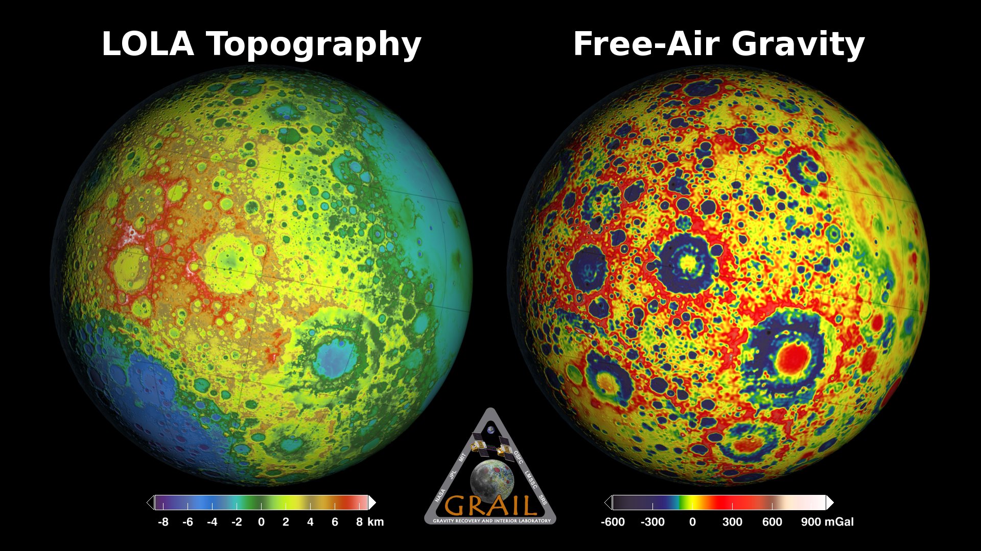
If the Moon were a perfectly smooth sphere of uniform density, the gravity map would be a single, featureless color, indicating that the force of gravity at a given elevation was the same everywhere. But like other rocky bodies in the solar system, including Earth, the Moon has both a bumpy surface and a lumpy interior. Spacecraft in orbit around the Moon experience slight variations in gravity caused by both of these irregularities.
The free-air gravity map shows deviations from the mean, the gravity that a cueball Moon would have. The deviations are measured in milliGals, a unit of acceleration. On the map, dark purple is at the low end of the range, at around -400 mGals, and red is at the high end near +400 mGals. Yellow denotes the mean.
These views show a part of the Moon's surface that's never visible from Earth. They are centered on lunar coordinates 29°N 142°E. The large, multi-ringed impact feature near the center is Mare Moscoviense. The crater Mendeleev is south of this. The digital elevation model for the terrain is from the Lunar Reconnaissance Orbiter laser altimeter (LOLA). Merely for plausibility, the sun angle and starry background are accurate for specific dates (December 21, 2012, 0:00 UT and January 8, 2013, 14:00 UT, respectively).
. About 75% of the visible disk is illuminated from the left, lighting longitudes roughly between 75° and 180° east. The view is centered on Mare Moscoviense, a feature on the far side.")
The GRAIL free-air gravity map of the Moon, rendered on the Moon's surface as it floats in front of a starry backdrop (the constellation Hydra). About 75% of the visible disk is illuminated from the left, lighting longitudes roughly between 75° and 180° east. The view is centered on Mare Moscoviense, a feature on the far side.
The GRAIL free-air gravity map of the Moon, rendered on the Moon's surface as it floats in front of a starry backdrop (the constellation Cetus). About 60% of the visible disk is illuminated from the right, lighting longitudes roughly between 130°E and 130°W. The view is centered on Mare Moscoviense, a feature on the far side.
The GRAIL free-air gravity map of the Moon, rendered on the Moon's surface, with no background (the image includes an alpha channel). About 75% of the visible disk is illuminated from the left, lighting longitudes roughly between 75° and 180° east. The view is centered on Mare Moscoviense, a feature on the far side.
The GRAIL free-air gravity map of the Moon, rendered on the Moon's surface, with no background (the image includes an alpha channel). About 60% of the visible disk is illuminated from the right, lighting longitudes roughly between 130°E and 130°W. The view is centered on Mare Moscoviense, a feature on the far side.
The starfield for the first image, a 13.7° field of view centered on 9h 7m, -12° 15', at the western end of the constellation Hydra. The bright star in the upper left is Alphard (alpha Hydrae).
The starfield for the second image, a 13.7° field of view centered on 2h 30m, -16° 38', a point near the eastern edge of the constellation Cetus. The four bright stars in the upper left quarter of the image are (clockwise from the top left) epsilon, rho, sigma, and pi Ceti.
Credits
Please give credit for this item to:
NASA's Goddard Space Flight Center Scientific Visualization Studio
-
Animator
-
Ernie Wright
(USRA)

-
Ernie Wright
(USRA)
-
Scientists
- Erwan M. Mazarico (Massachusetts Institute of Technology)
- Maria Zuber (Massachusetts Institute of Technology)
- David E. Smith (NASA/GSFC)
- Gregory A. Neumann (NASA/GSFC)
Missions
This page is related to the following missions:Series
This page can be found in the following series:Related papers
Datasets used
-
Bright Star Catalogue (Yale Bright Star Catalogue)
ID: 285This dataset can be found at: http://tdc-www.harvard.edu/catalogs/bsc5.html
See all pages that use this dataset -
Tycho Catalogue (Tycho 2 Catalogue) [Hipparcos: Telescope]
ID: 550This dataset can be found at: http://archive.eso.org/ASTROM/
See all pages that use this dataset -
UCAC3 (Catalog) [U.S. Naval Observatory: Third CCD Astrograph]
ID: 724 -
GRAIL Free-Air Gravity (Free-Air Gravity) [GRAIL: Lunar Gravity Ranging System]
ID: 766
Note: While we identify the data sets used on this page, we do not store any further details, nor the data sets themselves on our site.
Related
- ID: 4014
 Visualization
Release date
This page was originally published on Friday, February 8, 2013.
This page was last updated on Sunday, January 5, 2025 at 10:20 PM EST.