North America Snow Cover Maps
This entry contains Snow Cover Maps for Norh America with statelines, using the MODIS Cloud-gap-filled (CGF) Product at ~25-km resolution. The MODIS CGF product seeks to provide clear snow observations by filling cloudy areas on a given day with clear observations from previous days.The usual source for this product is the MOD10C1 MODIS/Terra Snow Cover Daily L3 Global 0.05Deg CMG, Version 5 and a variant has been coded that can use MOD10A1 MODIS/Aqua Snow Cover Daily L3 Global 500m Grid, Version 5 as source.
Maps are provided for various dates for 2006, 2010, 2011 and 2012, to compare snow cover between years.

Snow Cover Map of North America with US statelines on March 5, 2012.
Snow Cover Layer of North America on March 5, 2012 (with transparency)
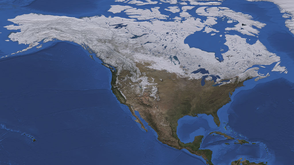
Snow Cover Map of North America with US statelines on January 22, 2012.
Snow Cover Layer of North America on January 22, 2012 (with transparency).
Snow Cover Map of North America with US statelines on March 3, 2011.
Snow Cover Layer of North America on March 3, 2011 (with transparency).
Snow Cover Map of North America with US statelines on February 1, 2010.
Snow Cover Layer of North America on February 1, 2010 (with transparency).
Snow Cover Map of North America with US statelines on February 1, 2006.
Snow Cover Layer of North America February 1, 2006 (with transparency).
Layer of United States borders and statelines (with transparency).
Blue Marble of North America layer.
Credits
Please give credit for this item to:
NASA/Goddard Space Flight Center Scientific Visualization Studio
-
Animator
-
Helen-Nicole Kostis
(USRA)

-
Helen-Nicole Kostis
(USRA)
-
Producers
- Rani Gran (NASA/GSFC)
- Malissa Reyes (USRA)
-
Scientists
- Dorothy Hall (NASA/GSFC)
- Jeffrey A. Miller (Wyle Information Systems)
-
Writer
- Ellen T. Gray (ADNET Systems, Inc.)
Missions
This page is related to the following missions:Datasets used
-
BMNG (Blue Marble: Next Generation) [Terra and Aqua: MODIS]
ID: 508Credit: The Blue Marble data is courtesy of Reto Stockli (NASA/GSFC).
This dataset can be found at: http://earthobservatory.nasa.gov/Newsroom/BlueMarble/
See all pages that use this dataset -
Bathymetry [Terra: MODIS]
ID: 569 -
MODIS Cloud-gap-filled (CGF) Product (Cloud-gap-filled MODIS daily snow-cover product) [Terra: MODIS]
ID: 734The MODIS CGF product seeks to provide clear snow observations by filling cloudy areas on a given day with clear observations from previous days. The usual source data for this product is the MOD10C1 MODIS/Terra Snow Cover Daily L3 Global 0.05Deg CMG, Version 5 and a variant has been coded that can use MOD10A1 MODIS/Aqua Snow Cover Daily L3 Global 500m Grid, Version 5 as source.
This dataset can be found at: http://www.sciencedirect.com/science/article/pil/S0034425709003162
See all pages that use this dataset
Note: While we identify the data sets used on this page, we do not store any further details, nor the data sets themselves on our site.
Related
- ID: 10945
 Produced Video
Release date
This page was originally published on Saturday, April 7, 2012.
This page was last updated on Wednesday, May 3, 2023 at 1:53 PM EDT.