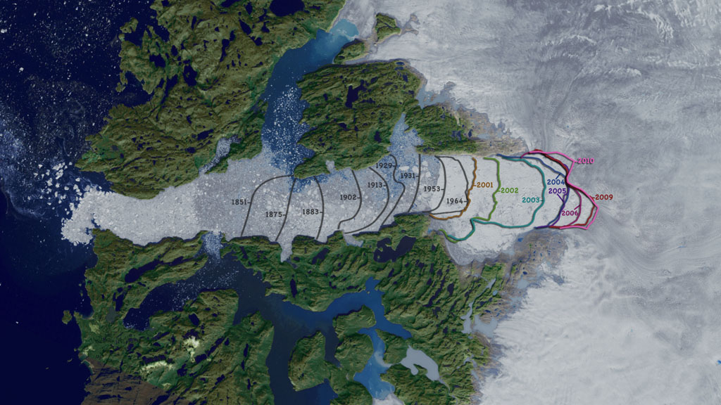
Orthographic View of Jakobshavn Calving Front: 1851 to 2010
The Jakobshavn Isbrae glacier, also known as Sermeq Kujalleq, is located on the west coast of Greenland at Latitude 69 degrees N. The ice front, where the glacier calves into the sea, receded more than 40 km between 1850 and 2010. Between 1850 and 1964 the ice front retreated at a steady rate of about 0.3 km/yr, after which it occupied approximately the same location until 2001, receding 10km in three years. After 2005 the single icefront had retreated enough to split into distinct fronts for the smaller, northern tributary and the main southern trunk. The icestream flows in a deep trough which ends near the current glacier terminus. The bedrock topography is expected to stabilize the location of the icefront for the near future as the glacier continues to drawn ice from Greenland's interior. The movement of ice from glaciers on land into the ocean contributes to a rise in sea level. Jakobshavn Isbrae is Greenland's largest outlet glacier, draining 6.5 percent of Greenland's ice sheet area.
This image is generated with an orthographic camera set to view the range from 51.372 W longitude to 49.212 W and from 68.94 N latitude to 69.39 N. The Landsat image shown in the background is a false color image of data collected on July 29, 2009.

The composite image of the Jakobshavn glacier with calving front lines, dates and a distance scale.

Calving front lines with transparency

Dates and the distance scale with transparency

False color background image generated from Landsat data observed on July 29, 2009.

Calving front with transparency derived from a Landsat image observed on Aug. 17, 2010.

Calving front with transparency derived from a Landsat image observed on July 29, 2009.

Calving front with transparency derived from a Landsat image observed on Aug. 6, 2006.

Calving front with transparency derived from an ASTER image observed on July 2, 2005.

Calving front with transparency derived from a Landsat image observed on Oct. 3, 2004.

Calving front with transparency derived from a Landsat image observed on Aug. 23, 2003.

Calving front with transparency derived from a Landsat image observed on Sept. 3, 2002.

Calving front with transparency derived from a Landsat image observed on July 7, 2001.

Historic calving front locations courtesy of Anker Weidick and Ole Bennike, Geological Survey of Denmark and Greenland. From left to right, these show the location of the calving front in 1851, 1875, 1883, 1902, 1913, 1929, 1931, 1953 and 1964.
Credits
Please give credit for this item to:
NASA/Goddard Space Flight Center Scientific Visualization Studio
Historic calving front locations courtesy of Anker Weidick and Ole Bennike, Geological Survey of Denmark and Greenland.
-
Visualizer
-
Cindy Starr
(Global Science and Technology, Inc.)
-
Cindy Starr
(Global Science and Technology, Inc.)
-
Animators
- Horace Mitchell (NASA/GSFC)
- Lori Perkins (NASA/GSFC)
-
Scientist
- Serdar Manizade (NASA/GSFC Wallops)
-
Project support
- James W. Williams (Global Science and Technology, Inc.)
- Shiloh Heurich (Global Science and Technology, Inc.)
Datasets used
-
Band Combination 3, 2, 1 [Landsat-7: ETM+]
ID: 537This dataset can be found at: http://landsat.gsfc.nasa.gov/about/wrs.html
See all pages that use this dataset -
Band Combination 7, 4, 2 [Landsat-7: ETM+]
ID: 650 -
Calving Front Line [Landsat: TM]
ID: 704Calving front lines derived from Landsat imagery.
See all pages that use this dataset -
Calving Front Lines [Terra: ASTER]
ID: 705Calving front lines derived from Terra/ASTER imagery.
See all pages that use this dataset
Note: While we identify the data sets used on this page, we do not store any further details, nor the data sets themselves on our site.
Release date
This page was originally published on Thursday, December 9, 2010.
This page was last updated on Wednesday, May 3, 2023 at 1:53 PM EDT.
