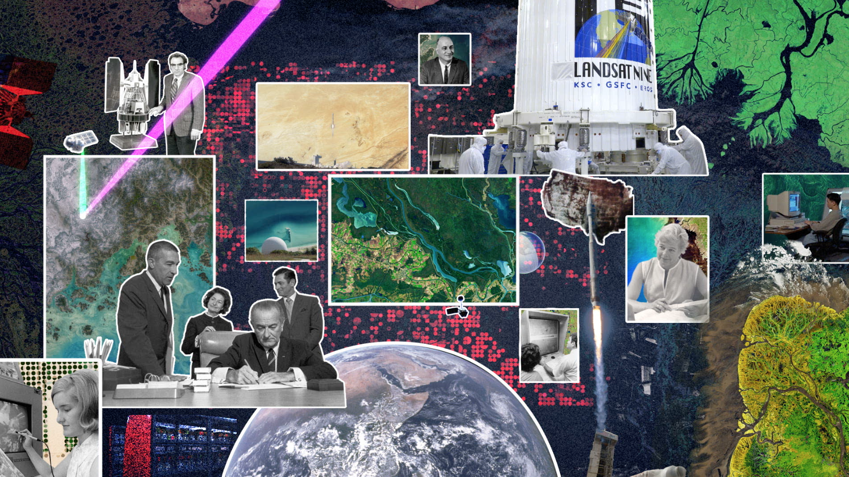
Landsat 9: Continuing the Legacy series
Five decades ago, NASA and the US Geological Society launched a satellite to monitor Earth’s land from space. It was the beginning of a legacy. The Apollo era had given us our first looks at Earth from space and inspired the idea of regularly collecting images of our planet. The first Landsat — originally known as the Earth Resources Technology Satellite, or ERTS — rocketed into space in 1972. Since then, there have been eight Landsats and we’re preparing to launch number nine.
The Landsat legacy stretches far and wide. Using visible and infrared light, Landsat helps track the health of crops, shows ocean pollution, and tracks coral reefs, icebergs and more. Thanks to sensor that can record wavelengths beyond what we can see with our eyes, Landsat can record vital information about Earth's surface.
Narrated by the actor Marc Evan Jackson, who played a Landsat scientist in the movie Kong: Skull Island (2017), this series of videos tells the story of Landsat 9. From the birth of the Landsat program to the present preparations for launching Landsat 9 and even a look to the future with Landsat NeXt.
Every legacy has a compelling origin. The soon-to-be-launched Landsat 9 is the intellectual and technical product of eight generations of Landsat missions, spanning nearly 50 years. Episode One answers the question “why?” Why did the specific years between 1962 and 1972 call for a such a mission? Why did leadership across agencies commit to its fruition? Why was the knowledge it could reveal important to the advancing study of earth science? In this episode, we’re introduced to William Pecora and Stewart Udall, two men who propelled the project into reality, as well as Virginia Norwood who breathed life into new technology. Like any worthwhile endeavor, Landsat encountered its fair share of resistance. Episode one explores how those challenges were overcome with the launch of Landsat 1, signifying a bold step into a new paradigm.
Additional footage courtesy of Gordon Wilkinson/Texas Archive of the Moving Image and the US Geological Survey.
Complete transcript available.
Music: "The Missing Star," "Brazenly Bashful," "Light Tense Weight," "It's Decision Time," "Patisserie Pressure," Universal Production Music
Watch this video on the NASA Goddard YouTube channel.
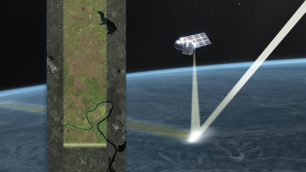
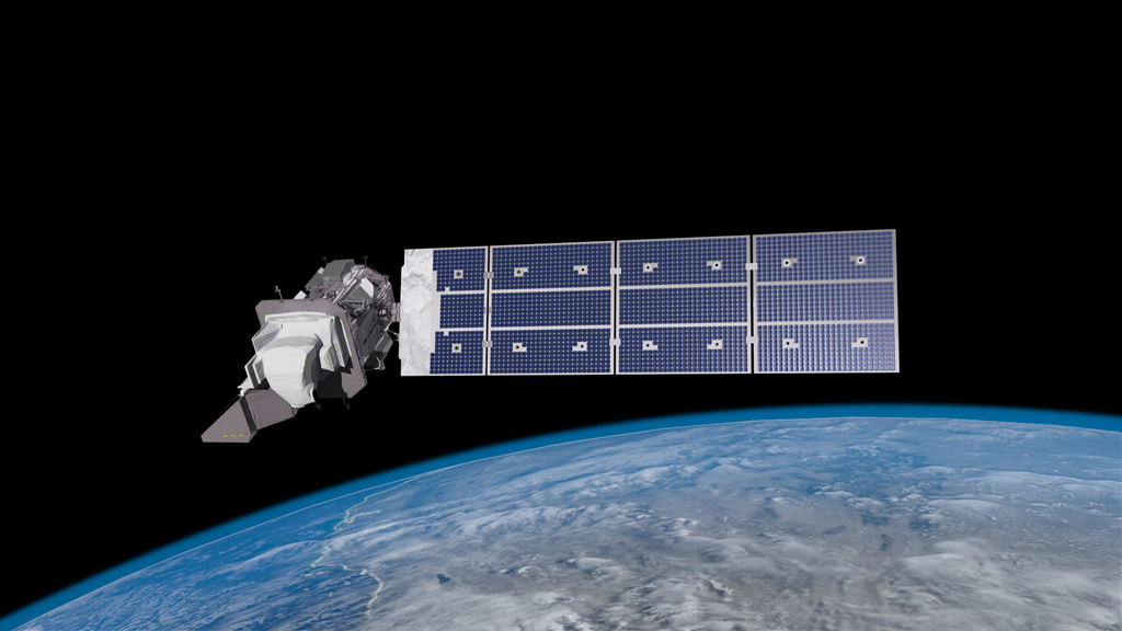
The early Landsat satellites carried a sensor that could “see” in visible light — like humans — plus a little bit of near-infrared light. Newer Landsats, including the coming Landsat 9 mission, have two sensors: the Operational Land Imager (OLI) and the Thermal Infrared Sensor (TIRS). Together, they see visible, near-infrared, shortwave-infrared, and thermal infrared wavelengths. By comparing observations of different wavelengths, scientists can identify algal blooms, storm damage, fire burn scars, the health of plants, and more.
The soon-to-be-launched Landsat 9 is the intellectual and technical product of eight generations of Landsat missions, spanning nearly 50 years. Episode 2 takes us inside the spacecraft, showing how Landsat instruments collect carefully calibrated data. Scientists have used the data to manage natural resources and answer questions about changes since the program started in 1972. In this episode, we’re introduced to Matt Bromley, who studies water usage in the western United States, as well as Phil Dabney and Melody Djam, who have worked on designing and building Landsat 9. Together, they are making sure that Landsat continues to deliver game-changing data and continues to help manage Earth’s precious resources.
Complete transcript available.
Music: "Crocodile Creek," "Clicking Into Place," "Playground Intrigue," "Fading Memories," "Innocent Activities," "Patisserie Pressure," from Universal Production Music
Watch this video on the NASA Goddard YouTube channel.
Landsat beams data down to ground stations on Earth, where it is recorded to four different drives as back up. The redundancy of data storage is really important. The Landsat legacy includes almost 50 years of observations of Earth from space — one of the longest space-based data records in existence.
The length of Landsat’s data record is crucial for studying change over time. From the growth of cities, to the extension of irrigation in the desert, to insect damage to forests, to plant regrowth after a volcanic eruption, Landsat lets us see our planet change. As of 2008, all of that data is free to the public. Anyone can download and use Landsat imagery — for everything from beautiful art to studying how our planet is changing.
It’s not enough just to record data with a satellite; you also need to analyze it here on Earth. Episode 3 shows the efforts of the USGS to downlink and archive the five decades of Landsat data we’ve collected, as well as make it available for scientists and other data users. In this episode, we’re introduced to Mike O’Brien, who is on the receiving end of daily downloads, as well as Kristi Kline, who is in charge of making Landsat data available at no cost to the user. Jeff Masek, the Landsat 9 Project Scientist at NASA, describes how access to data has revolutionized what we can learn about our home planet. More than just pictures, Landsat’s verified scientific data is giving us a slice of human history and the changes on Earth’s surface.
Additional footage courtesy of Pond5 and the US Geological Survey.
Complete transcript available.
Music: "Small Secrets," "Take A Little Look," "The Archives," "Golden Temple," "Orchestra Groove," "Perpetual Wonder," "Patisserie Pressure” from Universal Production Music
Watch this video on the NASA Goddard YouTube channel.
For the last 50 years, Landsat satellites have shown us Earth in unprecedented ways, but they haven’t operated alone. When it comes to studying our home planet, Landsat works in conjunction with other satellites from NASA and partner agencies like NOAA and the European Space Agency, as well as private companies. The old adage about teamwork holds true here: It’s made observations of Earth better!
After almost 50 years, the Landsat mission is still going strong. Every time a new satellite launches, it increases our knowledge of the planet we call home. Stay tuned for the launch of the newest Landsat satellite, coming Sept. 2021!
Landsat is not the only satellite orbiting Earth and sending back data. It takes a team of data sets to get the full picture of what’s happening down on the surface of Earth. Episode 4 shows how Landsat is combined with other data sets to reveal what is happening as well as why. In this episode, we’re introduced to Danielle Rappaport, who uses audio recordings with Landsat data to measure biodiversity in rainforests. Jeff Masek, the Landsat 9 Project Scientist at NASA, describes using Landsat and other data to understand depleted groundwater. As NASA builds Landsat 9, and other countries launch their own Earth observing satellites, the Landsat legacy continues to grow stronger than ever.
Additional footage courtesy of Pond5, Danielle Rappaport, and the US Geological Survey.
Complete transcript available.
Music: "Intrigues and Plots," "Finding You," “Very Fast Swing,” "Fence Trespassing," "Organic Circuit," "Show Me" from Universal Production Music.
Watch this video on the NASA Goddard YouTube channel.
The Landsat Program is a series of Earth-observing satellite missions jointly managed by NASA and the U.S. Geological Survey (USGS). Landsat satellites have been consistently gathering data about our planet since 1972. They continue to improve and expand this unparalleled record of Earth's changing landscapes for the benefit of all.
Credits
Please give credit for this item to:
NASA's Goddard Space Flight Center
Additional footage courtesy of Gordon Wilkinson/Texas Archive of the Moving Image, the US Geological Survey, and Pond5.
-
Producers
- Ryan Fitzgibbons (USRA)
- Matthew R. Radcliff (USRA)
- Kate Ramsayer (Telophase)
-
Animators
- Jacquelyn DeMink (USRA)
- Adriana Manrique Gutierrez (USRA)
-
Scientist
- Jeffrey Masek (NASA/GSFC)
-
Writer
- LK Ward (USRA)
-
Editor
- Ryan Fitzgibbons (USRA)
-
Interviewees
- Terry Arvidson (Lockheed Martin)
- Jeffrey Masek (NASA/GSFC)
- Matt Bromley (Desert Research Institute)
- Melody Djam (Bay Engineering Innovations)
- Philip Dabney (NASA/GSFC)
- Michael O'Brien (KBR Wyle Services, LLC)
- Kristi Kline (USGS)
- Danielle Rappaport (Conservation 4.0)
-
Narrator
Missions
This page is related to the following missions:Series
This page can be found in the following series:Related
- ID: 13917
 Produced Video
 - ID: 13920

Sources
- ID: 20322
 Animation
 - ID: 13259
 Produced Video
Release date
This page was originally published on Monday, November 30, 2020.
This page was last updated on Wednesday, May 3, 2023 at 1:44 PM EDT.