NASA To Launch Landsat 9: Continues Nearly 50-Year Legacy of Observing Earth from Space Live Shots

Quick link to edited B-ROLL
Quick link to canned interview with DR JEFF MASEK / Landsat 9 Project Scientist
Enlace para B-ROLL editado.
Enlace a la entrevista con el DR. JEFF MASEK / Landsat 9 Project Scientist
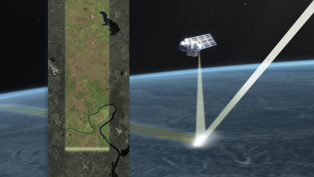
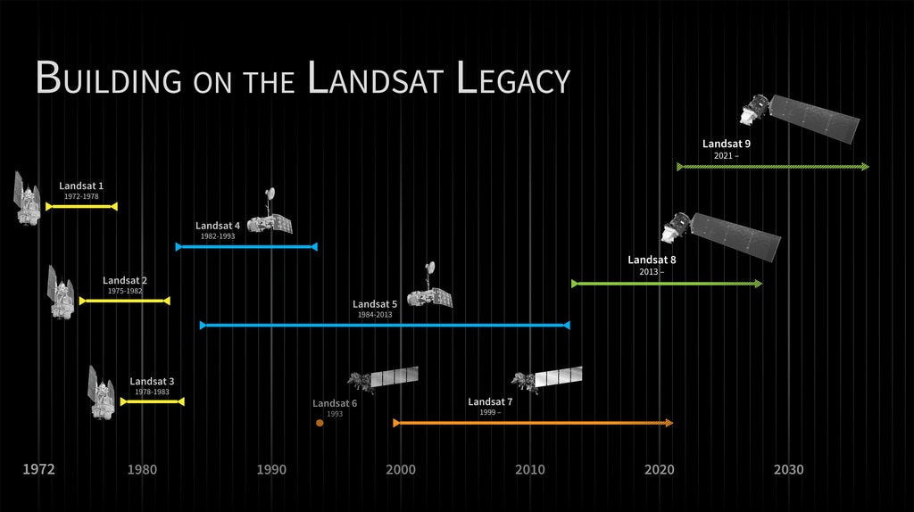
If you’ve used Google Earth, then you’ve seen images of our home planet that only a satellite can bring you. Many of these images come from the Landsat mission -- a joint venture between NASA and the U.S. Geological Survey (USGS). Since the first Landsat launch in 1972, Landsat satellites have provided us with continuous high-resolution images of Earth that are both stunning to look at, and packed with data that have helped shape our understanding of our planet. In particular, the decades-long data record helps researchers around the world understand how Earth is responding to natural and human-caused changes. Over almost 50 years, the Landsat satellites have watched as cities grow, rivers overflow their banks, sea levels rise, wildfires burn and farmers plant their crops. Canned interview with Dr. Jeff Masek/ Landsat 9 Project Scientist. TRT - 3:43. SOTS are separated by question slates. Full transcript is available. Click on the download button and you'll find the transcript plus video material Assocated b-roll for the Landsat 9 pre-launch live shots
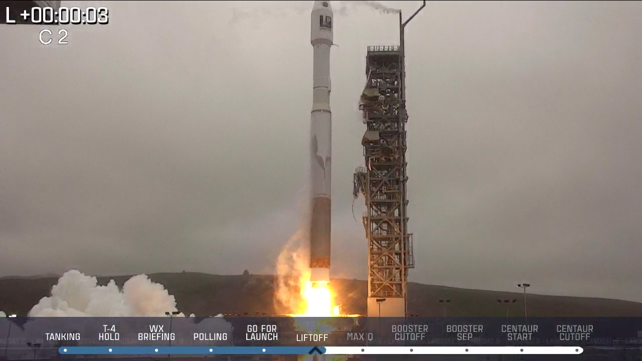
On Monday Sept. 27, NASA will launch Landsat 9, the next in a storied line of missions observing Earth’s surface. Launch window opens at 2:11pm EST / 11:11am PST that day!
The Landsat 9 observatory will continue to build on this understanding of our home planet with even higher imaging capabilities than previous Landsats.
Join NASA and USGS experts for one-on-one interviews just hours before Landsat 9 launches from Vandenberg Air Force Base in California.
Live interviews will be available from 6:00 a.m. to 12:30 p.m. EASTERN TIME on Monday, Sept. 27rd.
Click here to request an interview: https://forms.gle/vREXDyc8aaYzF1tu8
For more information about Landsat visit: https://www.nasa.gov/specials/landsat/
Please note that we may not be able to accommodate all requests for a specific expert. If we cannot fit your request we will offer alternatives.*
Suggested Anchor Intro:
If you’ve used Google Earth before you’ve seen images of our planet that only a satellite can bring you. Many of these images come from the Landsat mission, which has been monitoring how Earth is changing for nearly 50 years. NASA and the USGS will be launching Landsat 9 today to continue bringing you those images, which help experts manage wildfires and water resources and help track the impacts of climate change. Here to tell us about the mission is NASA [or USGS] scientist XX.
Suggested Questions:
Landsat 9 is launching today to continue the mission that started in 1972. What is the Landsat mission?
How is Landsat 9 different from the previous Landsat satellites?
Landsat is known for its beautiful images, but this data is telling us a lot about how our planet is changing. How does Landsat data directly help people on the ground?
Why is it important that NASA and USGS continue the Landsat mission?
Where can our viewers go to learn more about Landsat?
Questions for Longer Interviews:
How does this help people/resource managers?
How does this help us grow food?
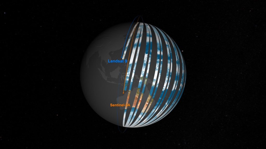
How often do Landsat satellites image a given place on Earth?
Credits
Please give credit for this item to:
NASA's Goddard Space Flight Center
-
Producers
- Michelle Handleman (KBR Wyle Services, LLC)
- Christina Brooke Mitchell (KBR Wyle Services, LLC)
- Matthew Radcliff (KBR Wyle Services, LLC)
- LK Ward (KBR Wyle Services, LLC)
- Jessica Sansarran (NASA)
- Courtney A. Lee (ADNET Systems, Inc.)
- Pedro Cota (ADNET Systems, Inc.)
- Maria-Jose Vinas Garcia (Telophase)
- Misael Andres Pagan Charriez (NASA)
Release date
This page was originally published on Thursday, September 23, 2021.
This page was last updated on Wednesday, May 3, 2023 at 1:43 PM EDT.
Series
This visualization can be found in the following series:Related
- ID: 13946
 Produced Video
 - ID: 13889
![Landsat 9, launching September 2021, will collect the highest quality data ever recorded by a Landsat satellite, while still ensuring that these new measurements can be compared to those taken by previous generations of the Earth-observing satellite. Landsat 9 will enable or improve measurements of water quality, glacial ice velocity, crop water usage, and much more.Music: The Waiting Room by Sam Dodson [PRS], Afterglow by Christopher Timothy White [PRS], both published by Atmosphere Music Ltd [PRS]; and Inner Strength by Brava/Dsilence/Input/Output [SGAE], published by El Murmullo Sarao [SGAE] and Universal Sarao [SGAE]. Available from Universal Production Music. Complete transcript available.Watch this video on the NASA Goddard YouTube channel.](/vis/a010000/a013800/a013889/13889_Landsat9_at_Work_print.png) Produced Video
Produced Video - ID: 13800
![From space, satellites including the NASA and U.S. Geological Survey’s (USGS) Landsat 8 can help scientists identify lakes where an algal bloom has formed. It’s a complicated data analysis process, but one that researchers are automating so resource managers around the country can use the satellite data to identify potential problems.Music: Light From Dark by Adam Salkedi, Neil Pollard [PRS], published by Atmosphere Music Ltd.; Experimental Design by Laurent Dury [SACEM], published by Koka Media; Against The Wall by Benjamin Peter McAvoy [PRS], published by Sound Pocket Music; Brainstorming by Laurent Dury[SACEM], published by Koka Media; Together As One by Le Fat Club [SACEM], Olivier Grim [SACEM]; published by Koka Media.Complete transcript available.Watch this video on the NASA Goddard YouTube channel.](/vis/a010000/a013800/a013800/13800_aquatic_reflection_poster.png) Produced Video
Produced Video - ID: 20322
 Animation
 - ID: 13712
 Produced Video
 - ID: 13247
![Video promoting the technological advances of Landsat 9, continuing the legacy of global land imaging begun in 1972. The video highlights the origin of the Landsat program and some of the many benefits we receive from its data.Music: Marble Place by Matias Suescun [SACEM], published by KTSA Publishing [SACEM], available from Universal Production Music Complete transcript available.Watch this video on the NASA Goddard YouTube channel.](/vis/a010000/a013200/a013247/Landsat9_teaser_20200723_youtube.00142_print.jpg) Produced Video
Produced Video - ID: 4745
 Visualization
 - ID: 13259
 Produced Video
 - ID: 11433
 Produced Video