Antarctica Exposed
Our understanding of what lies beneath the world's biggest ice sheet has taken another leap forward. Thanks to work led by the British Antarctic Survey, scientists have a new 3D map of Antarctica’s ice and bedrock. The map, called Bedmap2, incorporates millions of new measurements, including data collected by NASA's ICESat satellite and airborne Operation IceBridge mission. The result is a virtual reconstruction of the continent’s bedrock topography and ice layers captured in never-before-seen detail. Antarctica plays a large role in the global climate system. The melting and emptying of its ice into the sea influences ocean currents and the rate of sea level rise. By having a precise map of Antarctica’s mountains, ridges, slopes and valleys—all of which affect how fast the continent's ice travels across the ice sheet—scientists can better predict future rates of ice flow. Watch the video to learn more.

Scientists peel back the continent’s ice to explore its underlying bedrock.
Watch this narrated video for a closer look at Antarctica's ice and bedrock.
The original Bedmap (lower left) provided a groundbreaking view below the ice even though it was lower resolution than Bedmap2 (upper right).
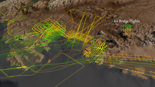
Airborne campaigns contributed 25 million measurements to Bedmap2. Shown above are flight paths from NASA's Operation IceBridge mission.
The colored lines above show the velocity of observed ice flows. Bedmap2 will help scientists make projections of future ice flow.
For More Information
See NASA.gov
Credits
Please give credit for this item to:
NASA's Goddard Space Flight Center
-
Animators
-
Cindy Starr
(Global Science and Technology, Inc.)

-
Greg Shirah
(NASA/GSFC)
- Horace Mitchell (NASA/GSFC)
-
Cindy Starr
(Global Science and Technology, Inc.)
-
Video editors
-
Cindy Starr
(Global Science and Technology, Inc.)
- Jefferson Beck (USRA)
-
Cindy Starr
(Global Science and Technology, Inc.)
-
Narration
- Jefferson Beck (USRA)
-
Narrator
- Jefferson Beck (USRA)
-
Producer
- Jefferson Beck (USRA)
-
Scientists
- William Krabill (NASA/GSFC Wallops)
- Eric J. Rignot (NASA/JPL CalTech)
- Peter Fretwell (British Antarctic Survey)
- H. D. Pritchard (British Antarctic Survey)
- D. G. Vaughan (British Antarctic Survey)
- J. L. Bamber (School of Geographical Sciences, University of Bristol, UK)
- N. E. Barrand (British Antarctic Survey)
- R. Bell (Lamont-Doherty Earth Observatory of Columbia University)
- C. Bianchi (Istituto Nazionale di Geofisica e Vulcanologia)
- R. G. Bingham (School of Geosciences, University of Aberdeen)
- Donald D. Blankenship (Institute for Geophysics, University of Texas at Austin)
- G. Casassa (Centro de Estudios Cientificos)
- G. Catania (Institute for Geophysics, University of Texas at Austin)
- D. Callens (Laboratoire de Glaciologie, Universit)
- H. Conway (Earth and Space Sciences, University of Washington)
- A. J. Cook (Department of Geography, Swansea University)
- H. F. J. Corr (British Antarctic Survey)
- V. Damm (Federal Institute for Geosciences and Natural Resources)
- R. Forsberg (National Space Institute, Technical University of Denmark)
- Y. Gim (NASA/JPL CalTech)
- P. Gogineni (Electrical Engineering and Computer Science, University of Kansas)
- J. A. Griggs (School of Geographical Sciences, University of Bristol)
- R. C. A. Hindmarsh (British Antarctic Survey)
- P. Holmlund (Stockholm University)
- J. W. Holt (Institute for Geophysics, University of Texas at Austin)
- R. W. Jacobel (St. Olaf College)
- A. Jenkins (British Antarctic Survey)
- Wilfried Jokat (Alfred Wegener Institute)
- T. Jordan (British Antarctic Survey)
- E. C. King (British Antarctic Survey)
- J. Kohler (Norwegian Polar Institute, Fram Centre)
- M. Riger-Kusk (College of Science, University of Canterbury)
- K. A. Langley (Department of Geosciences, University of Oslo)
- G. Leitchenkov (Institute for Geology and Mineral Resources of the World Ocean)
- C. Leuschen (Electrical Engineering and Computer Science, University of Kansas)
- B. P. Luyendyk (Earth Research Institute, University of California, Santa Barbara)
- Kenichi Matsuoka (Norwegian Polar Institute)
- Jeremie Mouginot (University of California, Irvine)
- F. O. Nitsche (Lamont-Doherty Earth Observatory of Columbia University)
- Y. Nogi (National Institute of Polar Research)
- O. A. Nost (Norwegian Polar Institute)
- S. V. Popov (Polar Marine Geosurvey Expedition)
- D. M. Rippin (Environment Department, University of York)
- A. Rivera (Centro de Estudios Cientificos)
- J. Roberts (Department of Sustainability, Environment, Water, Population and Communities, Australian Antarctic Division)
- N. Ross (School of Geography, Politics and Sociology, Newcastle University)
- M. J. Siegert (School of Geographical Sciences, University of Bristol)
- A. M. Smith (British Antarctic Survey)
- Daniel Steinhage (Alfred Wegener Institute)
- Michael Studinger (NASA/GSFC)
- Bo Sun (Polar Research Institute of China)
- B. K. Tinto (Lamont-Doherty Earth Observatory of Columbia University)
- B. C. Welch (Alfred Wegener Institute)
- D. Wilson (Instituite for Crustal Studies, University of California)
- Duncan A. Young (Institute for Geophysics, University of Texas)
- C. Xiangbin (Polar Research Institute of China)
- A. Zirizzotti (Istituto Nazionale di Geofisica e Vulcanologia)
-
Writer
- Jefferson Beck (USRA)
Related
- ID: 4060
 Visualization
Release date
This page was originally published on Thursday, June 20, 2013.
This page was last updated on Wednesday, May 3, 2023 at 1:52 PM EDT.