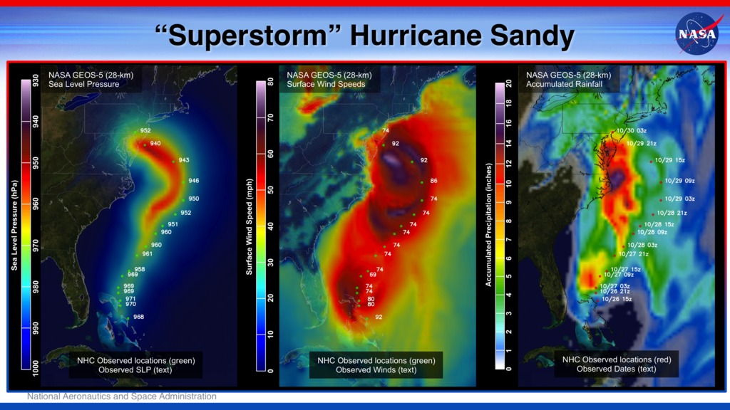
Tracking A Superstorm
Hurricane Sandy pummeled the East Coast late in 2012’s Atlantic hurricane season, causing 159 deaths and $70 billion in damages. Days before landfall, forecasts of its trajectory were still being made. Some computer models showed that a trough in the jet stream would kick the monster storm away from land and out to sea. Among the earliest to predict its true course was NASA’s GEOS-5 global atmosphere model. The model works by dividing Earth’s atmosphere into a virtual grid of stacked boxes. A supercomputer then solves mathematical equations inside each box to create a weather forecast predicting Sandy’s structure, path and other traits. The NASA model not only produced an accurate track of Sandy, but also captured fine-scale details of the storm’s changing intensity and winds. Watch the video to see it for yourself.

A NASA computer model simulates the astonishing track and forceful winds of Hurricane Sandy.
Hurricane Sandy’s near-surface winds are visible in this computer simulation that runs from Oct. 26 to Oct. 31, 2012.
Oct. 25, 2012 – Sandy reached its initial peak intensity as a Category 3 hurricane over Cuba.
Oct. 26, 2012 – Sandy’s winds hit speeds greater than 90 mph as the storm grew over the Atlantic.
Oct. 29, 2012 – A day before landfall, Sandy intensified into a Category 2 superstorm nearly 1,000 miles wide.
Oct. 30, 2012 – Post-landfall effects ranged from record storm surge in New Jersey to blizzards in North Carolina.
For More Information
See NASA.gov
Credits
Please give credit for this item to:
NASA's Goddard Space Flight Center and NASA Center for Climate Simulation
Video and images courtesy of NASA/GSFC/William Putman
-
Animator
- William Putman (NASA/GSFC)
-
Video editor
- Kayvon Sharghi (USRA)
-
Scientist
- William Putman (NASA/GSFC)
-
Writer
- Jarrett Cohen (Global Science and Technology, Inc.)
Related
- ID: 30019
 Hyperwall Visual
Release date
This page was originally published on Thursday, June 6, 2013.
This page was last updated on Wednesday, May 3, 2023 at 1:52 PM EDT.