Earth
ID: 3186
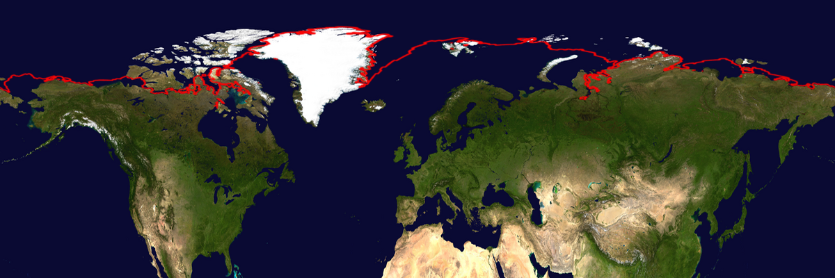
Each year, the ice covering the Arctic Ocean grows during the northern hemisphere winter and shrinks with the northern hemisphere summer. The ice extent is usually greatest during the month of March and is the least during the month of September. This image shows the average minimum extent of sea ice over the northern hemisphere during the month of September over 24 seasons, from 1979 - 2002. The red line shows the area where the average sea ice concentration is 15%.

Minimum Sea Ice Extent (WMS)
Visualization Credits
Eric Sokolowsky (GST): Lead Animator
Cindy Starr (Global Science and Technology, Inc.): Visualizer
Walt Meier (NSIDC): Scientist
Cindy Starr (Global Science and Technology, Inc.): Visualizer
Walt Meier (NSIDC): Scientist
Please give credit for this item to:
NASA/Goddard Space Flight Center Scientific Visualization Studio
NASA/Goddard Space Flight Center Scientific Visualization Studio
Short URL to share this page:
https://svs.gsfc.nasa.gov/3186
Data Used:
Note: While we identify the data sets used in these visualizations, we do not store any further details nor the data sets themselves on our site.
This item is part of this series:
WMS
Keywords:
DLESE >> Cryology
GCMD >> Earth Science >> Cryosphere >> Sea Ice >> Ice Extent
GCMD >> Earth Science >> Oceans >> Sea Ice >> Ice Extent
SVS >> Hyperwall
NASA Science >> Earth
GCMD keywords can be found on the Internet with the following citation: Olsen, L.M., G. Major, K. Shein, J. Scialdone, S. Ritz, T. Stevens, M. Morahan, A. Aleman, R. Vogel, S. Leicester, H. Weir, M. Meaux, S. Grebas, C.Solomon, M. Holland, T. Northcutt, R. A. Restrepo, R. Bilodeau, 2013. NASA/Global Change Master Directory (GCMD) Earth Science Keywords. Version 8.0.0.0.0
https://svs.gsfc.nasa.gov/3186
Data Used:
Nimbus-7/SMMR
1979-2002DMSP/SSM/I/Sea Ice Climatology
1979-2002This item is part of this series:
WMS
Keywords:
DLESE >> Cryology
GCMD >> Earth Science >> Cryosphere >> Sea Ice >> Ice Extent
GCMD >> Earth Science >> Oceans >> Sea Ice >> Ice Extent
SVS >> Hyperwall
NASA Science >> Earth
GCMD keywords can be found on the Internet with the following citation: Olsen, L.M., G. Major, K. Shein, J. Scialdone, S. Ritz, T. Stevens, M. Morahan, A. Aleman, R. Vogel, S. Leicester, H. Weir, M. Meaux, S. Grebas, C.Solomon, M. Holland, T. Northcutt, R. A. Restrepo, R. Bilodeau, 2013. NASA/Global Change Master Directory (GCMD) Earth Science Keywords. Version 8.0.0.0.0


