Earth
ID: 30899

Hurricane Irma churned across the Atlantic Ocean in September 2017, battering several Caribbean islands before moving on to the Florida Keys and the U.S. mainland. As the clouds cleared over places like the Virgin Islands, the destruction became obvious even from space.
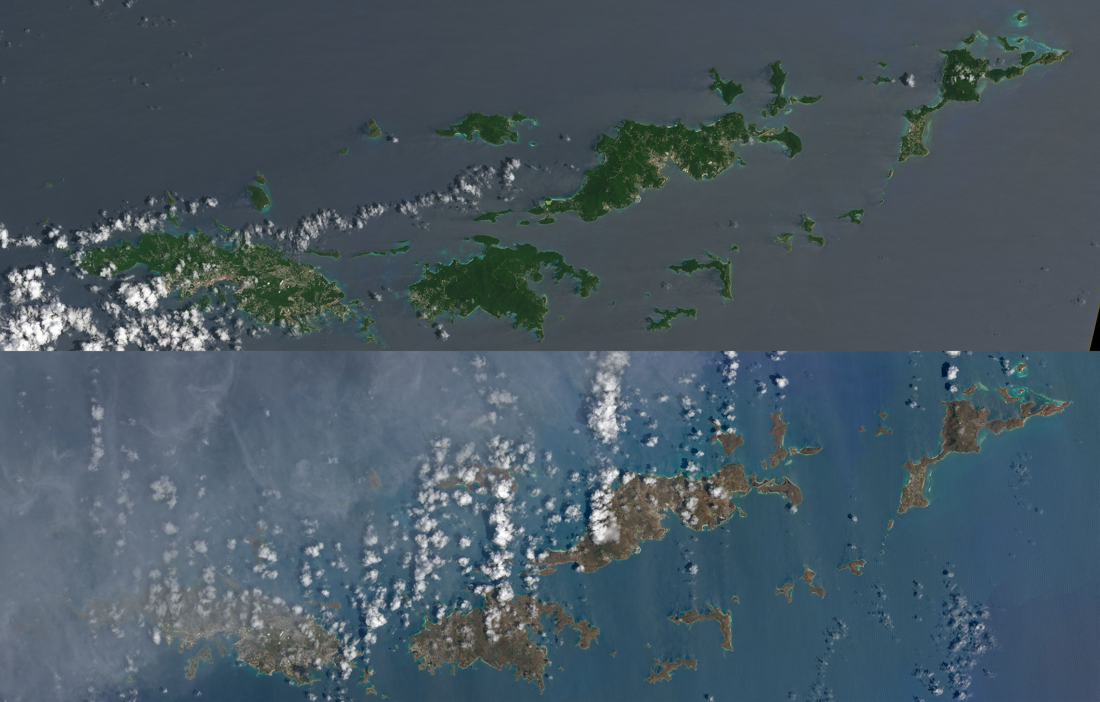
These natural-color images, captured by the Operational Land Imager (OLI) on the Landsat 8 satellite, show some of Irma’s effect on the British and U.S. Virgin Islands. The views were acquired on August 25 and September 10, 2017, before and after the storm passed. They are among the few relatively cloud-free satellite images of the area so far.
The most obvious change is the widespread browning of the landscape. There are a number of possible reasons for this. Lush green tropical vegetation can be ripped away by a storm’s strong winds, leaving the satellite with a view of more bare ground. Also, salt spray whipped up by the hurricane can coat and desiccate leaves while they are still on the trees.
Irma passed the northernmost Virgin Islands on the afternoon of September 6. At the time, Irma was a category 5 storm with maximum sustained winds of 185 miles (295 kilometers) per hour. According to news reports, the islands saw “significant devastation.”
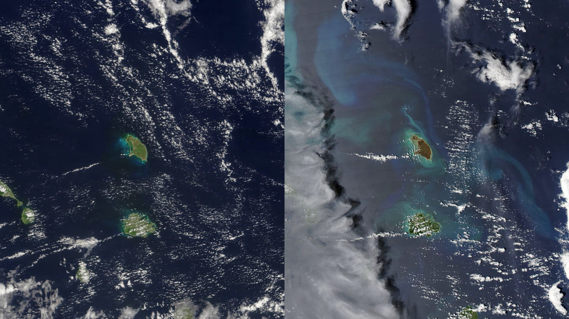
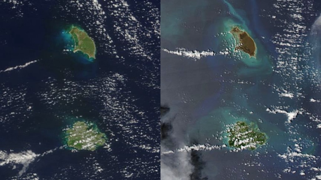
The destruction is also clearly visible on Barbuda. This small island in the eastern Caribbean was directly hit by the category-5 storm early on September 6. These images were acquired by the Moderate Resolution Imaging Spectroradiometer (MODIS) on NASA’s Terra and Aqua satellites. The left image shows Barbuda on August 21, 2017. The right image shows the ravaged landscape on September 8.
In contrast, vegetation on Antigua appears relatively healthy and intact. With the storm’s center passing to the north, the island sustained less damage. Ground reports noted that by September 7, electricity had been restored to most of the island, and the international airport reopened.
Hurricane Irma Turns Caribbean Islands Brown
These natural-color images, captured by the Operational Land Imager (OLI) on the Landsat 8 satellite, show some of Irma’s effect on the British and U.S. Virgin Islands. The views were acquired on August 25 and September 10, 2017, before and after the storm passed. They are among the few relatively cloud-free satellite images of the area so far.
The most obvious change is the widespread browning of the landscape. There are a number of possible reasons for this. Lush green tropical vegetation can be ripped away by a storm’s strong winds, leaving the satellite with a view of more bare ground. Also, salt spray whipped up by the hurricane can coat and desiccate leaves while they are still on the trees.
Irma passed the northernmost Virgin Islands on the afternoon of September 6. At the time, Irma was a category 5 storm with maximum sustained winds of 185 miles (295 kilometers) per hour. According to news reports, the islands saw “significant devastation.”
The destruction is also clearly visible on Barbuda. This small island in the eastern Caribbean was directly hit by the category-5 storm early on September 6. These images were acquired by the Moderate Resolution Imaging Spectroradiometer (MODIS) on NASA’s Terra and Aqua satellites. The left image shows Barbuda on August 21, 2017. The right image shows the ravaged landscape on September 8.
In contrast, vegetation on Antigua appears relatively healthy and intact. With the storm’s center passing to the north, the island sustained less damage. Ground reports noted that by September 7, electricity had been restored to most of the island, and the international airport reopened.
For More Information
Credits
Amy Moran (Global Science and Technology, Inc.): Lead Animator
Kathryn Hansen (SSAI): Lead Writer
Joshua Stevens (SSAI): Lead Data Visualizer
Kathryn Hansen (SSAI): Lead Writer
Joshua Stevens (SSAI): Lead Data Visualizer
Please give credit for this item to:
NASA's Goddard Space Flight Center
NASA's Goddard Space Flight Center
Short URL to share this page:
https://svs.gsfc.nasa.gov/30899
Keywords:
SVS >> Landsat
GCMD >> Earth Science >> Biosphere >> Vegetation
GCMD >> Earth Science >> Atmosphere >> Atmospheric Phenomena >> Hurricanes
GCMD >> Location >> Virgin Islands
GCMD >> Location >> Caribbean
SVS >> Hyperwall
SVS >> MODIS
NASA Science >> Earth
NASA Earth Science Focus Areas >> Weather and Atmospheric Dynamics
GCMD keywords can be found on the Internet with the following citation: Olsen, L.M., G. Major, K. Shein, J. Scialdone, S. Ritz, T. Stevens, M. Morahan, A. Aleman, R. Vogel, S. Leicester, H. Weir, M. Meaux, S. Grebas, C.Solomon, M. Holland, T. Northcutt, R. A. Restrepo, R. Bilodeau, 2013. NASA/Global Change Master Directory (GCMD) Earth Science Keywords. Version 8.0.0.0.0


