Two Decades of Precipitation
Overview
NASA has released its newest and most comprehensive estimate of rain and snow covering nearly 20 years. Version 6 of NASA's IMERG -- short for the Integrated Multi-satellitE Retrievals for Global Precipitation Measurement (GPM) -- combines information from a constellation of satellties that are operating in Earth's orbit, at a given time, to estimate precipitation over the majority of the Earth's surface.
Data Visualizations
- ID: 4759 Visualization
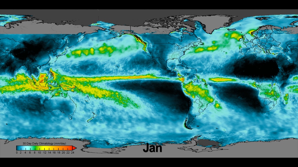
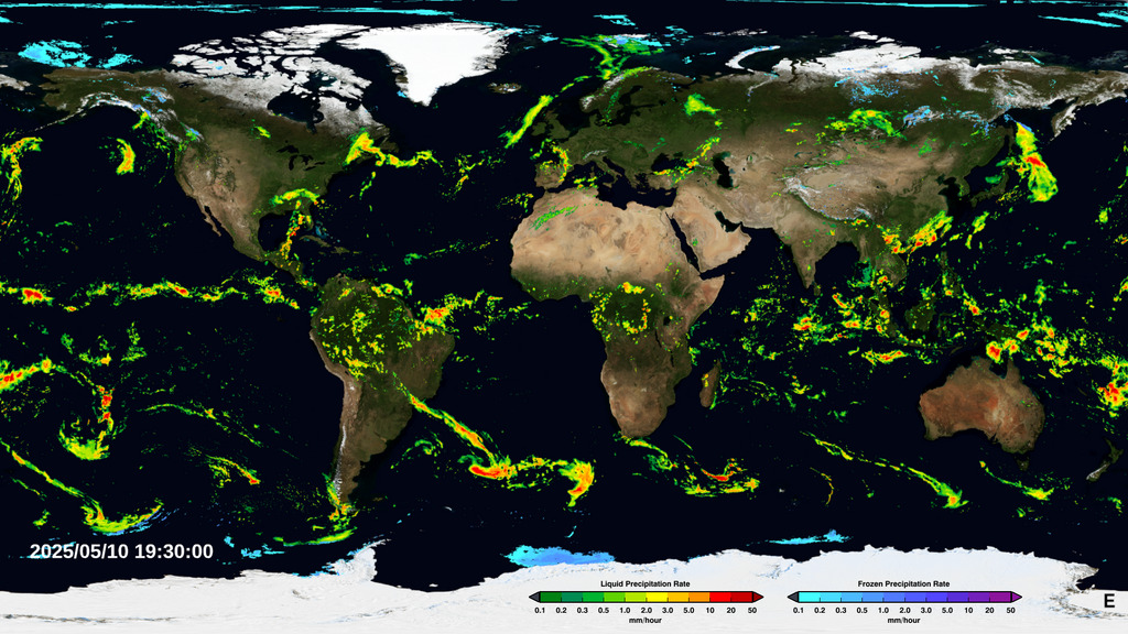
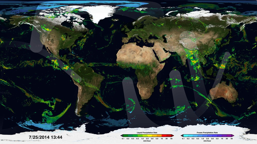
IMERG Daily Climatology
Go to this pageExample composite showing the daily climatology along with the appropriate month and colorbar. || daily_clim_black_comp.0000_print.jpg (1024x576) [163.0 KB] || daily_clim_black_comp.0000_thm.png (80x40) [7.7 KB] || daily_clim_black_comp.0000_searchweb.png (180x320) [95.0 KB] || daily_clim_black_comp_1080p30.mp4 (1920x1080) [53.6 MB] || daily_clim_black_comp_1080p30.webm (1920x1080) [8.1 MB] || example_composite (3840x2160) [0 Item(s)] || daily_clim_black_comp_2160p30.mp4 (3840x2160) [147.5 MB] || daily_clim_black_comp_1080p30.mp4.hwshow [195 bytes] ||
- ID: 4760 Visualization
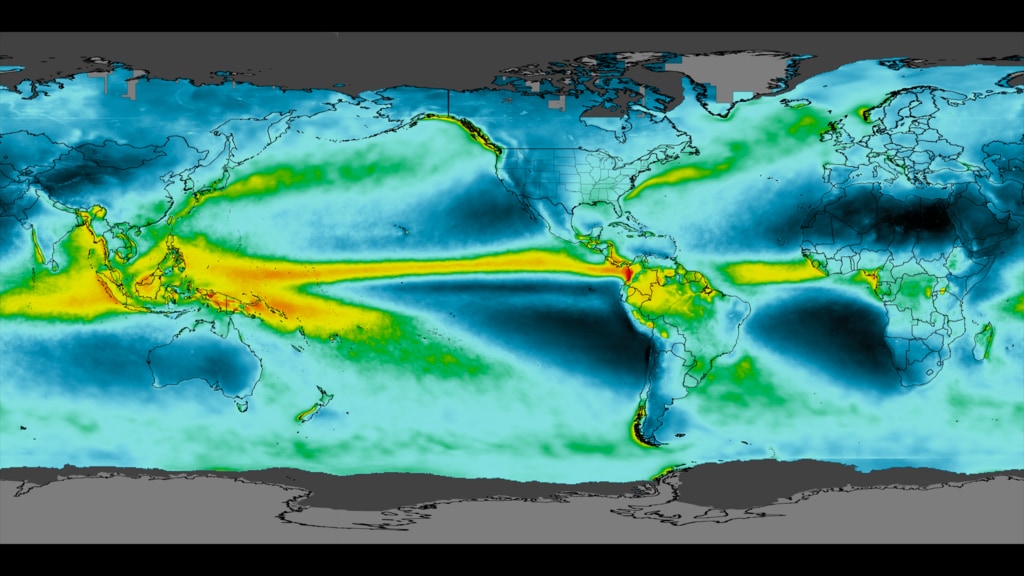
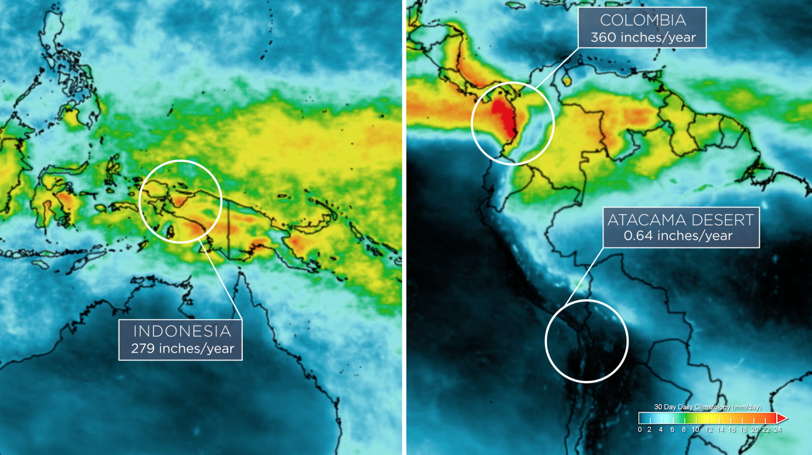
Grand Average Precipitation Climatology
Go to this pageGrand Average Precipitation Climatology || grand_average_climatology2_black_print.jpg (1024x576) [128.5 KB] || grand_average_climatology2_black_searchweb.png (320x180) [87.7 KB] || grand_average_climatology2_black_thm.png (80x40) [8.0 KB] || grand_average_climatology2_black.tif (3840x2160) [80.5 MB] ||
- ID: 13346 Produced Video
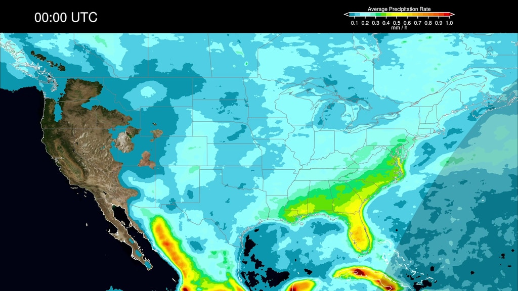
Precipitation Diurnal Cycles
Go to this pageThe daily cycle of weather, also known as the diurnal cycle, shapes how and when our weather develops and is fundamental to regulating our climate. These animations show the most detailed view of the diurnal cycles over the United States. They were created using NASA's newest extended precipitation record known as the Integrated Multi-satellitE Retrievals for GPM, or IMERG analysis.The IMERG analysis combines almost 20 years of rain and snow data from the Tropical Rainfall Measuring Mission (TRMM) and the joint NASA-JAXA Global Precipitation Measurement mission (GPM).Learn more at NASA.gov. ||
- ID: 13347 Produced Video
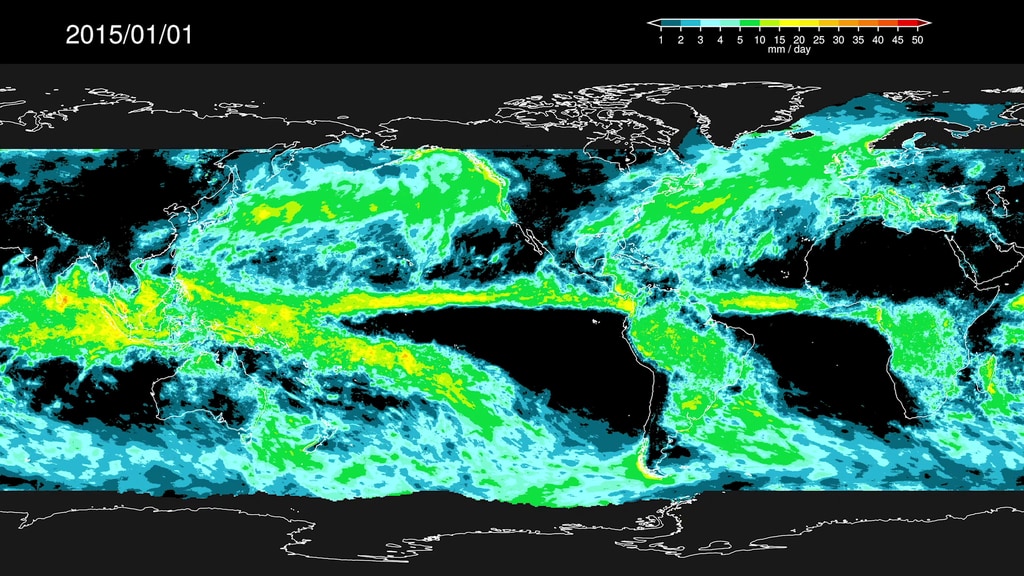
Precipitation Accumulation and Anomalies
Go to this page2015-2016 Precipitation Accumulation || 2015-16_Accumulation.00001_print.jpg (1024x576) [204.0 KB] || 2015-16_Accumulation.00001_searchweb.png (320x180) [98.8 KB] || 2015-16_Accumulation.00001_thm.png (80x40) [7.8 KB] || 2015-16_Accumulation.mp4 (1920x1080) [71.3 MB] || 2015-16_Accumulation_4K.webm (3840x2160) [27.8 MB] || accumulation (3840x2160) [0 Item(s)] || 2015-16_Accumulation_4K.mov (3840x2160) [3.4 GB] ||
Edited Features
- ID: 13345 Produced Video
NASA Remasters Nearly 20 Years of Global Rain
Go to this pageMusic: "Synchronicity," "The Ocean and the Moon," "Cloud Surfing," Universal Production MusicComplete transcript available. || IMERG_Thumb2.png (1672x938) [2.3 MB] || IMERG_Thumb2_print.jpg (1024x574) [141.1 KB] || IMERG_Thumb2_searchweb.png (320x180) [117.2 KB] || IMERG_Thumb2_thm.png (80x40) [8.4 KB] || 13345_IMERG20_v2_prores.webm (1920x1080) [32.5 MB] || 13345_IMERG20_v2.mp4 (1920x1080) [465.7 MB] || 13345_IMERG20.en_US.srt [5.3 KB] || 13345_IMERG20.en_US.vtt [5.3 KB] || 13345_IMERG20_v2_prores.mov (1920x1080) [3.9 GB] ||
- ID: 13348 Produced Video
![Complete transcript available.Music Credits: "Battle For Our Future" and "Wonderful Orbit" by Tom Furse Fairfax Cowan [PRS], "Transitions" by Ben Niblett [PRS] and Jon Cotton [PRS], "Emerging Discovery by "Rik Carter [PRS] from Killer Tracks](/vis/a010000/a013300/a013348/13348_DailyCycleOfRain_YouTube.00561_print.jpg)
NASA’s New View of the Daily Cycle of Rain
Go to this pageThe most detailed view of our daily weather has been created using NASA's newest extended precipitation record known as the Integrated Multi-satellitE Retrievals for GPM, or IMERG analysis.The IMERG analysis combines almost 20 years of rain and snow data from the Tropical Rainfall Measuring Mission (TRMM) and the joint NASA-JAXA Global Precipitation Measurement mission (GPM).The daily cycle of weather, also known as the diurnal cycle, shapes how and when our weather develops and is fundamental to regulating our climate. ||
The Global Precipitation Measurement Mission
- ID: 4285 Visualization
Near Real-Time Global Precipitation from the Global Precipitation Measurement Constellation
Go to this pageAn animation of the most currently available global precipitation data from IMERG.
- ID: 4369 Visualization
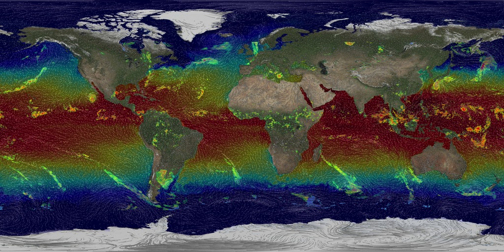
Painting the World with Water (New Colorbar)
Go to this pageAn animation depicting the build-up of precipitation data on a flat map from the Global Precipitation Measurement constellation of satellites, resulting in the IMERG global precipitation data set.This video is also available on our YouTube channel. || GPM_Fleet_IMERG_new_1080p.00556_print.jpg (1024x576) [197.6 KB] || GPM_Fleet_IMERG_new_1080p.00556_searchweb.png (320x180) [97.5 KB] || GPM_Fleet_IMERG_new_1080p.00556_thm.png (80x40) [7.3 KB] || flatcomposite (1920x1080) [0 Item(s)] || GPM_Fleet_IMERG_new_1080p_30.webm (1920x1080) [33.8 MB] || GPM_Fleet_IMERG_new_1080p_30.mp4 (1920x1080) [470.0 MB] || flatcomposite (3600x1800) [0 Item(s)] || flatalpha (3600x1800) [0 Item(s)] || GPM_Fleet_IMERG_new_4369.pptx [96.1 MB] || GPM_Fleet_IMERG_new_4369.key [98.6 MB] || date_layer_black (350x80) [0 Item(s)] || GPM_Fleet_IMERG_new_1080p_30.mp4.hwshow [225 bytes] ||
- ID: 11392 Produced Video
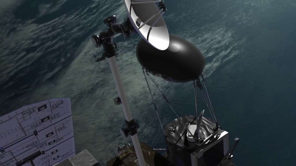
GPM Core Spacecraft Beauty Passes
Go to this pageA variety of animated beauty passes of the Global Precipitation Measurement (GPM) Core spacecraft. ||
- ID: 12126 Produced Video
Science On a Sphere: A Global Tour of Precipitation from NASA
Go to this pagePrecipitation (falling rain and snow) is our fresh water reservoir in the sky and is fundamental to life on Earth. A Global Tour of Precipitation from NASA shows how rain and snowfall moves around the world from the vantage of space using measurements from the Global Precipitation Measurement Core Observatory, or GPM. This is a joint mission between NASA and the Japanese Aerospace Exploration Agency (JAXA) and offers the most detailed and worldwide view of rain and snowfall ever created.This narrated movie is created for Science On a Sphere, a platform designed by NOAA that displays movies on a spherical screen. Audiences can view the movie from any side of the sphere and can see any part of Earth. During this show viewers will be guided through a variety of precipitation patterns and display features such as the persistent band of the heaviest rainfall around the equator and tight swirls of tropical storms in the Northern Hemisphere. At subtropical latitudes in both hemispheres there are persistent dry areas and this is where most of the major deserts reside. Sea surface temperature and winds are also shown to highlight the interconnectedness of the Earth system. The movie concludes with near real-time global precipitation data from GPM, which is provided to Science On a Sphere roughly six hours after the observation.To download this movie formatted for a spherical screen, visit NOAA's official Science On a Sphere website below:• A Global Tour of Precipitation from NASA• Near Real-Time Global Precipitation Data ||
NASA Earth Science
- ID: 4698 Visualization
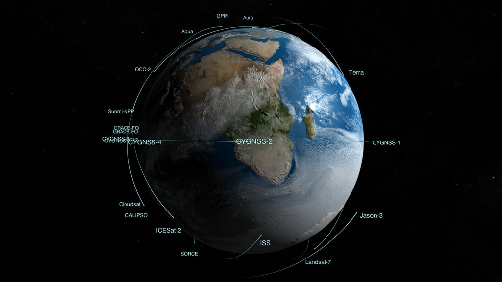
Earth Observing Fleet (October 2018)
Go to this pageNASA's Earth Science Fleet as of October 2018 || fleet201810_hd01.07410_print.jpg (1024x576) [71.1 KB] || fleet201810_hd01.07410_searchweb.png (320x180) [64.9 KB] || fleet201810_hd01.07410_thm.png (80x40) [4.8 KB] || 1920x1080_16x9_60p (1920x1080) [0 Item(s)] || fleet201810_hd01.webm (1920x1080) [51.8 MB] || fleet201810_hd01.mp4 (1920x1080) [229.8 MB] || 9600x3240_16x9_30p (9600x3240) [0 Item(s)] || fleet201810_hd01.mp4.hwshow [182 bytes] ||