Hurricane Maria One Year Later
Overview
In September 2017, Hurricane Maria struck Puerto Rico head-on as a Category 4 storm with winds topping 155 miles per hour. The storm damaged homes, flooded towns, devastated the island's forests and caused the longest electricity black-out in U.S. history.
Two new NASA research efforts delve into Hurricane Maria's far-reaching effects on the island's forests as seen in aerial surveys with high-resolution lidar and on its residents' energy and electricity access as seen in Night Lights satellite data from space. The findings, presented Monday at the American Geophysical Union meeting in Washington, D.C., illustrate the staggering scope of Hurricane Maria's damage to both the natural environment and communities and expose vulnerabilities in infrastructure.
Night Lights and Energy Use
Miguel Román
- ID: 4658 Visualization
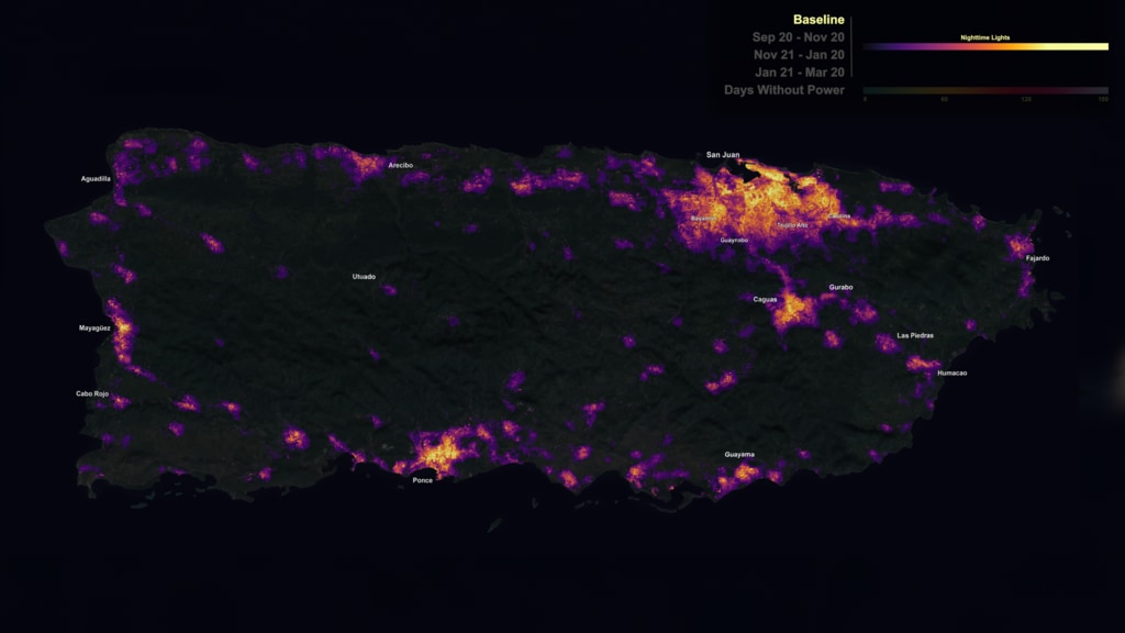
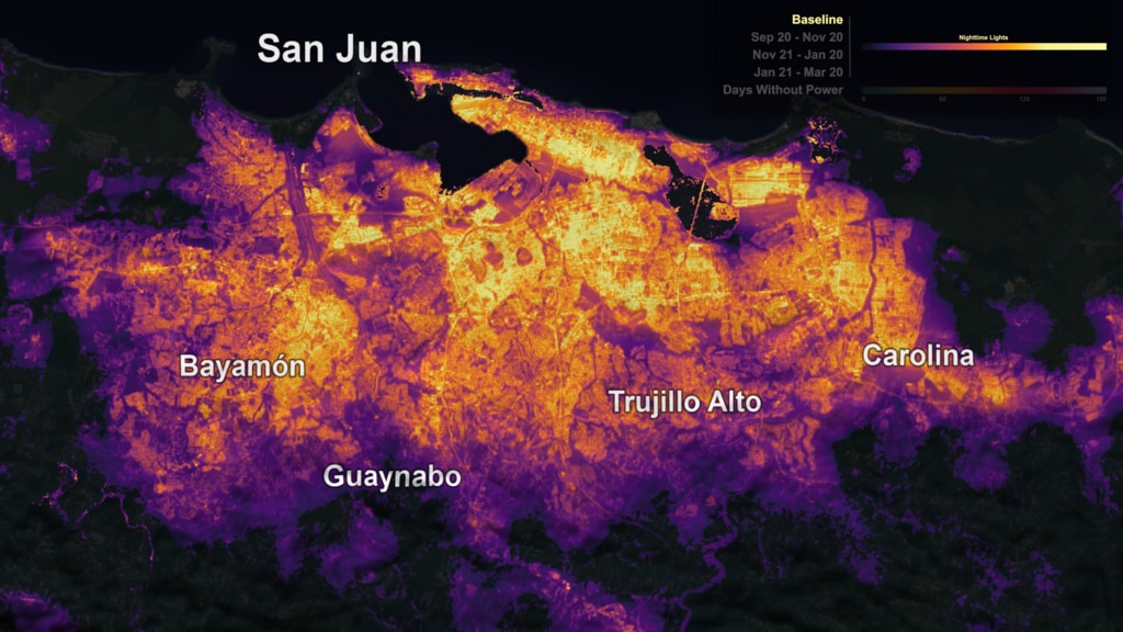
NASA's Black Marble night lights used to examine disaster recovery in Puerto Rico
Go to this pageAt night, Earth is lit up in bright strings of roads dotted with pearl-like cities and towns as human-made artificial light takes center stage. During Hurricane Maria, Puerto Rico's lights went out.In the days, weeks, and months that followed, research physical scientist Miguel Román at NASA's Goddard Space Flight Center in Greenbelt, Maryland, and his colleagues combined NASA's Black Marble night lights data product from the NASA/NOAA Suomi National Polar-orbiting Partnership satellite with USGS-NASA Landsat data and Google's OpenStreetMap to develop a neighborhood-scale map of energy use in communities across Puerto Rico as the electricity grid was slowly restored. They then analyzed the relationship between restoration rates in terms of days without electricity and the remoteness of communities from major cities. ||
- ID: 12616 Produced Video
Black Marble View of Puerto Rico After Hurricane Maria
Go to this pageScientist Miguel Román and colleagues combined NASA's Black Marble night lights data product from the NASA/NOAA Suomi National Polar-orbiting Partnership with data from USGS-NASA Landsat satellites and other sources to produce a neighborhood-scale map of energy use in communities across Puerto Rico as electricity was restored after Hurricane Maria in 2017.Complete transcript available.Watch this video on the NASA Goddard YouTube channel. || 12616_BlackMarblePR_Thumbnail_print.jpg (1024x576) [148.9 KB] || 12616_BlackMarblePR_Thumbnail.png (3840x2160) [10.1 MB] || 12616_BlackMarblePR_Thumbnail_searchweb.png (320x180) [107.2 KB] || 12616_BlackMarblePR_Thumbnail_thm.png (80x40) [7.6 KB] || 12616_BlackMarblePR_FINAL_prores_720.mov (1280x720) [1.1 GB] || 12616_BlackMarblePR_FINAL_youtube_1080.mp4 (1920x1080) [191.2 MB] || 12616_BlackMarblePR_FINAL_youtube_720.mp4 (1280x720) [162.0 MB] || 12616_BlackMarblePR_FINAL_twitter_720.mp4 (1280x720) [31.6 MB] || 12616_BlackMarblePR_FINAL.webm (960x540) [38.8 MB] || 12616_BlackMarblePR_FINAL_prores_4K.mov (4096x2160) [8.2 GB] || 12616_BlackMarblePR_FINAL.mp4 (3840x2160) [160.5 MB] || 12616_BlackMarblePR_FINAL_youtube_4k.mp4 (3840x2160) [524.0 MB] || 12616_BlackMarblePR_FINAL_Captions.en_US.srt [2.1 KB] ||
Forest Lidar and Aerial Photos
Doug Morton
- ID: 4624 Visualization
El Yunque National Forest, Puerto Rico Canopy Change from Afar (2017-2018)
Go to this pageSample Composite that split screens the lidar swath over the El Yunque National Forest, Puerto Rico. During the split screen, 2017 data is on the upper left and 2018 data on the bottom right. As the camera moves northwest, the viewer can see patches of ground becoming visible in the 2018 data. This is due to the vast numbers of trees that were stripped or fell during Hurricane Maria in September 2017. || el_verde_comp.0190_print.jpg (1024x576) [368.1 KB] || el_verde_comp.0800.png (1920x1080) [3.0 MB] || el_verde_comp.0190_searchweb.png (320x180) [115.9 KB] || el_verde_comp.0190_thm.png (80x40) [6.0 KB] || el_verde_comp_1080p30.mp4 (1920x1080) [247.1 MB] || Sample_Composite (1920x1080) [256.0 KB] || el_verde_comp_1080p30.webm (1920x1080) [11.9 MB] || el_verde_comp.0800.tif (1920x1080) [5.9 MB] ||
- ID: 4621 Visualization
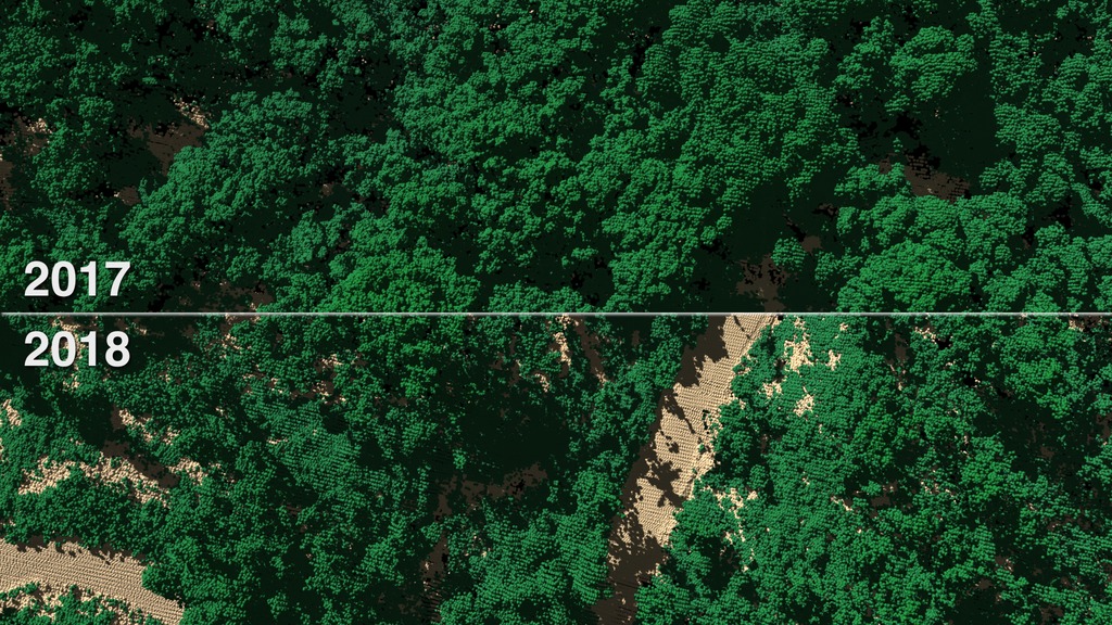
El Yunque National Forest, Puerto Rico Canopy Change Nadir View (2017-2018)
Go to this pageAnimation that does of a low fly over of El Yunque National Forest, Puerto Rico. The entire animation is split screen showing the 2017 data on top and 2018 on bottom. Notice the dense lush forest canopy in 2017 and how it covers and shades much of the forest floor. However, in 2018, after Maria devastated the forest in late 2017, the tree canopy has been greatly thinned exposing much more of the forest floor. || evzoom_comp4.0300_print.jpg (1024x576) [316.8 KB] || evzoom_comp4.0300_searchweb.png (320x180) [121.7 KB] || evzoom_comp4.0300_thm.png (80x40) [7.3 KB] || evzoom_comp4_1080p30.mp4 (1920x1080) [199.0 MB] || Sample_Composite (1920x1080) [256.0 KB] || evzoom_comp4_1080p30.webm (1920x1080) [15.4 MB] ||
- ID: 12590 Produced Video
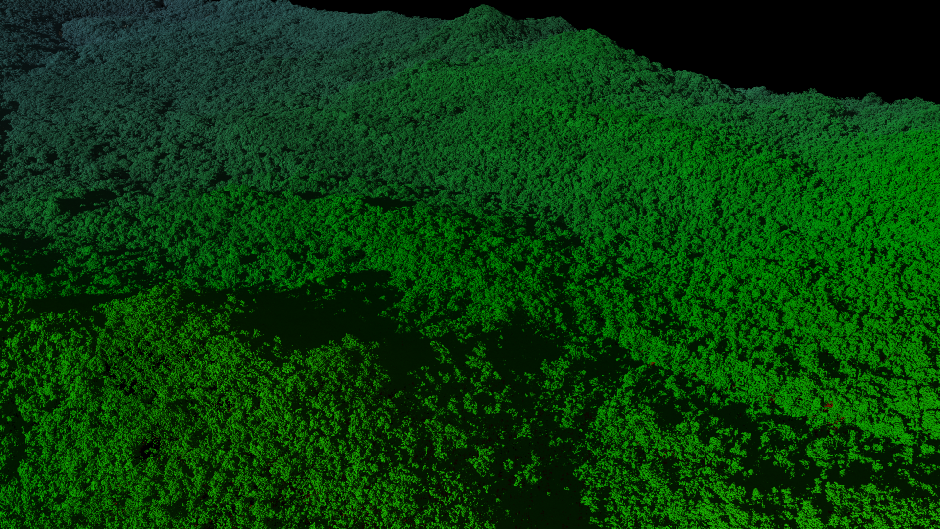
![To get a detailed look at vegetation and land cover, NASA uses an airborne instrument called Goddard’s Lidar, Hyperspectral and Thermal Airborne Imager, or G-LiHT. From the belly of a small aircraft flying one thousand feet above the trees, G-LiHT collects multiple measurements of forests, including high-resolution photographs, surface temperatures and the heights and structure of the vegetation. Watch this video on the NASA Goddard YouTube channel.Complete transcript available.Music: Letting the Past Go, by Ben Hales [PRS], Matt Hales [PRS]](/vis/a010000/a012500/a012590/12590_Puerto_Rico_lidar_youtube_1080.00248_print.jpg)
3-D Views of Puerto Rico's Forests After Hurricane Maria
Go to this pageTo get a detailed look at vegetation and land cover, NASA uses an airborne instrument called Goddard’s Lidar, Hyperspectral and Thermal Airborne Imager, or G-LiHT. From the belly of a small aircraft flying one thousand feet above the trees, G-LiHT collects multiple measurements of forests, including high-resolution photographs, surface temperatures and the heights and structure of the vegetation. Watch this video on the NASA Goddard YouTube channel.Complete transcript available.Music: Letting the Past Go, by Ben Hales [PRS], Matt Hales [PRS] || 12590_Puerto_Rico_lidar_youtube_1080.00248_print.jpg (1024x576) [311.0 KB] || 12590_Puerto_Rico_lidar_youtube_1080.00248_searchweb.png (320x180) [126.9 KB] || 12590_Puerto_Rico_lidar_youtube_1080.00248_thm.png (80x40) [6.4 KB] || 12590_Puerto_Rico_lidar_prores.mov (1920x1080) [1.7 GB] || 12590_Puerto_Rico_lidar_youtube_1080.mp4 (1920x1080) [193.0 MB] || 12590_Puerto_Rico_lidar_youtube_720.mp4 (1280x720) [182.1 MB] || 12590_Puerto_Rico_lidar_twitter_720.mp4 (1280x720) [29.6 MB] || 12590_Puerto_Rico_lidar.webm (960x540) [49.2 MB] || 12590_Puerto_Rico_lidar-captions.en_US.srt [1.6 KB] || 12590_Puerto_Rico_lidar-captions.en_US.vtt [1.6 KB] ||
- ID: 12991 Produced Video
![Overview of field expedition to Puerto Rico in April 2018, to survey the recovery of forests since Hurricanes Irma and Maria hit the island seven months before.Complete transcript available.Music: Treehouse Imaginations by Zachary Scott Lemon [BMI]Down Terrace by Damien Deschamps [SACEM]Reloj by Kevin Carbo [BMI]Living Forest by Luca Proietti [SIAE]Watch this video on the NASA Goddard YouTube channel.](/vis/a010000/a012900/a012991/12991-mangroves_and_plane_wing_IMG_0852.jpg)
NASA Surveys Hurricane Damage to Puerto Rico's Forests
Go to this pageOverview of field expedition to Puerto Rico in April 2018, to survey the recovery of forests since Hurricanes Irma and Maria hit the island seven months before.Complete transcript available.Music: Treehouse Imaginations by Zachary Scott Lemon [BMI]Down Terrace by Damien Deschamps [SACEM]Reloj by Kevin Carbo [BMI]Living Forest by Luca Proietti [SIAE]Watch this video on the NASA Goddard YouTube channel. || 12991-mangroves_and_plane_wing_IMG_0852.jpg (5184x3456) [1.3 MB] || 12991-mangroves_and_plane_wing_IMG_0852_searchweb.png (320x180) [84.2 KB] || 12991-mangroves_and_plane_wing_IMG_0852_thm.png (80x40) [6.2 KB] || 12991_Puerto_Rico_lidar_V2_prores.mov (1920x1080) [8.9 GB] || 12991_Puerto_Rico_lidar_V2_youtube_1080.mp4 (1920x1080) [558.3 MB] || 12991_Puerto_Rico_lidar_V2.mp4 (1920x1080) [328.9 MB] || 12991_Puerto_Rico_lidar_V2_large.mp4 (1920x1080) [343.8 MB] || 12991_Puerto_Rico_lidar_V2_youtube_720.mp4 (1280x720) [563.1 MB] || 12991_Puerto_Rico_lidar_twitter_720.mp4 (1280x720) [78.7 MB] || 12991_Puerto_Rico_lidar.webm (1920x1080) [39.1 MB] || 12991_Puerto_Rico_lidar-captions.en_US.srt [7.4 KB] || 12991_Puerto_Rico_lidar-captions.en_US.vtt [7.4 KB] ||
 Link
LinkG-LiHT Data Archive
G-LiHT Lidar, passive optical and thermal data provide an analytical framework for the development of new algorithms to map plant species composition, plant functional types, biodiversity, biomass and carbon stocks, and plant growth. G-LiHT data is also used to initialize and validate 3D radiative transfer models, and intercalibrate Earth observing satellites. G-LiHT was specifically designed for use with a wide range of common, general aviation aircraft in order to provide affordable, well-calibrated image data worldwide.
Go to this link Link
LinkAerial Photos Flickr Album
A Flickr album of photos from NASA's G-LiHT campaign to Puerto Rico in April 2018 to study the forest recovery since Hurricane Maria.
Go to this link