NASA's Black Marble night lights used to examine disaster recovery in Puerto Rico
At night, Earth is lit up in bright strings of roads dotted with pearl-like cities and towns as human-made artificial light takes center stage. During Hurricane Maria, Puerto Rico's lights went out.
In the days, weeks, and months that followed, research physical scientist Miguel Román at NASA's Goddard Space Flight Center in Greenbelt, Maryland, and his colleagues combined NASA's Black Marble night lights data product from the NASA/NOAA Suomi National Polar-orbiting Partnership satellite with USGS-NASA Landsat data and Google's OpenStreetMap to develop a neighborhood-scale map of energy use in communities across Puerto Rico as the electricity grid was slowly restored. They then analyzed the relationship between restoration rates in terms of days without electricity and the remoteness of communities from major cities.
This visualization starts with a global view of hurricane Maria hitting Puerto Rico. We then zoom in to Puerto Rico to compare the standard night lights dataset to a new, high definition version of nights lights. After the hurricane passes over the island, we see a massive drop in night light intensity due to loss of power. After showing night light levels over several stages of hurricane recovery, we transition to a 'Days Without Power' dataset. The camera then zooms in to several locations around the island to examine each stage of recovery in more detail.
This visualization starts with a global view of hurricane Maria hitting Puerto Rico. We then zoom in to Puerto Rico to compare the standard night lights dataset to a new, high definition version of nights lights. After the hurricane passes over the island, we see a massive drop in night light intensity due to loss of power. After showing night light levels over several stages of hurricane recovery, we transition to a 'Days Without Power' dataset. The camera then zooms in to several locations around the island to examine each stage of recovery in more detail. This version has no legend/labels.

Still image - Hurricane Maria just after passing over Puerto Rico
Still image - Puerto Rico night lights after Hurricane Maria passes over (path shown here in red)
Color bar for night light intensity
Color bar for number of days without power
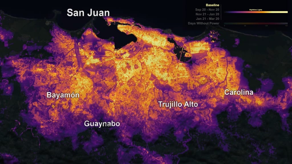
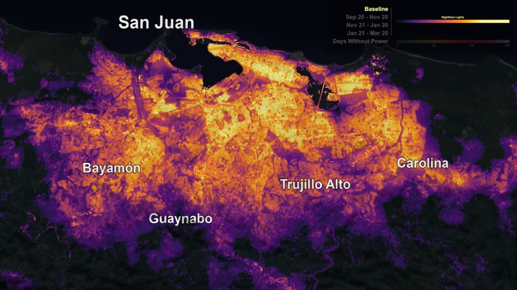
Print resolution still - This view of Puerto Rico shows number of days without power. Greens and yellows are fewer days (0-60), and reds and pinks are more days (120-180). (With and without city labels)
Print resolution still - This view of Puerto Rico shows number of days without power. Greens and yellows are fewer days (0-60), and reds and pinks are more days (120-180).
Print resolution still - This view of Puerto Rico shows number of days without power. Greens and yellows are fewer days (0-60), and reds and pinks are more days (120-180).
Print resolution still - Baseline (pre-storm) view of Puerto Rico night lights. (With and without city labels)
Print resolution still - Average night lights 2 months (Sep 20 - Nov 20) after Hurricane Maria passed over Puerto Rico. (With and without city labels)
Print resolution still - Average night lights 3-4 months (Nov 21- Jan 20) after Hurricane Maria hit Puerto Rico. (With and without city labels)
Print resolution still - Average night lights 5-6 months (Jan 21- Mar 20) after Hurricane Maria hit Puerto Rico. (With and without city labels)
Print resolution still - Baseline (pre-storm) view of San Juan night lights.
Print resolution still - Average San Juan night lights 2 months (Sep 20 - Nov 20) after Hurricane Maria passed over Puerto Rico.
Credits
Please give credit for this item to:
NASA's Scientific Visualization Studio
-
Visualizer
-
Kel Elkins
(USRA)

-
Kel Elkins
(USRA)
-
Scientist
- Miguel Román (NASA/GSFC)
-
Producers
- Ellen T. Gray (ADNET Systems, Inc.)
- Matthew R. Radcliff (USRA)
Datasets used
-
VIIRS [Suomi NPP: VIIRS]
ID: 722
Note: While we identify the data sets used on this page, we do not store any further details, nor the data sets themselves on our site.
Used as a Source In
- ID: 4742
 Visualization
 - ID: 13216
![Complete transcript available.Music credits: “Northern Breeze” by Denis Levaillant [SACEM], “Stunning Horizon” by Maxime Lebidois [SACEM], Ronan Maillard [SACEM], “Magnetic Force” by JC Lemay [SACEM] from Killer TracksWatch this video on the NASA Goddard YouTube channel.This video can be freely shared and downloaded. While the video in its entirety can be shared without permission, some individual imagery provided by pond5.com is obtained through permission and may not be excised or remixed in other products. Specific details on stock footage may be found here. For more information on NASA’s media guidelines, visit https://www.nasa.gov/multimedia/guidelines/index.html.Notes on footage:• 0:03 - 0:17 provided by Pond5• 1:38 - 1.43 provided by Pond5• 1:49 - 1:52 provided by Pond5• 2:21 - 1:27 provided by Pond5](/vis/a010000/a013200/a013216/13216_NASA_Has_Eyes_On_The_Atlantic_Hurricane_Season_YouTube.00050_print.jpg) Produced Video
Produced Video - ID: 13188
![Music: After the Sun by Andrew Michael Britton [PRS], David Stephen Goldsmith [PRS], Andrew Skeet [PRS]Complete transcript available.](/vis/a010000/a013100/a013188/Still_print.jpg) Produced Video
Produced Video - ID: 12396
 Produced Video
 - ID: 12616
 Produced Video
Release date
This page was originally published on Sunday, December 9, 2018.
This page was last updated on Tuesday, September 17, 2019 at 3:04 PM EDT.