Earth
ID: 5003
Landsat Next is the follow on mission to Landsat-9. Landsat Next which will provide data continuity to the decades long data record of the Earth’s land from space. It is still in the planning stages and is targeted for launch around 2030. Landsat Next is planned to have more than twice the number of bands as Landsat 8 and 9 and will consist of 3 separate spacecraft. This reduces amount of time needed for full Earth coverage to around 6 days.
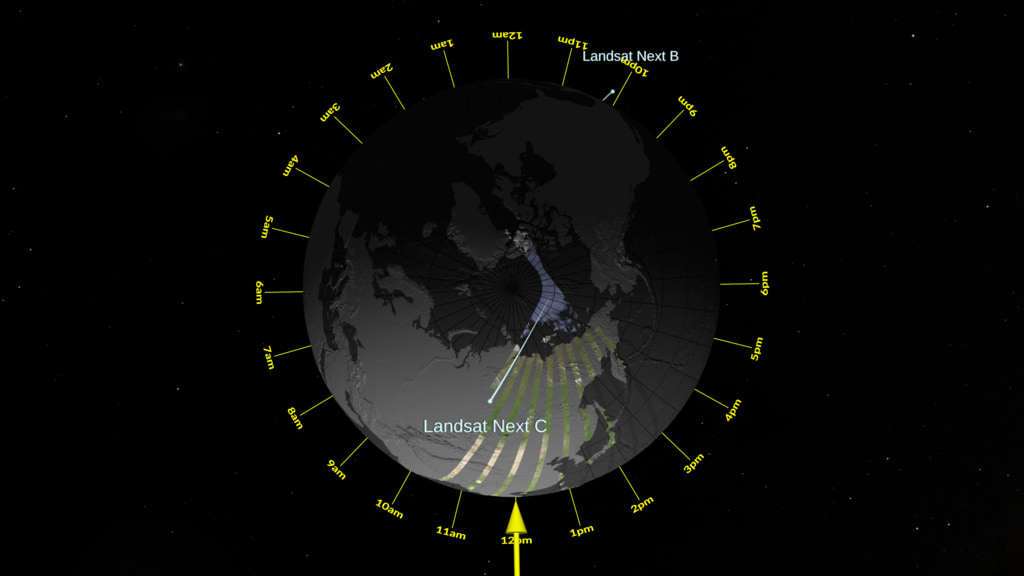
These visualizations show example orbits and swaths of Landsat Next. The orbit swath widths shown are 164km wide. There are 2 versions: one is more equatorial, the other is more polar.
The equatorial view shows the spacecraft orbits and swaths slowly appearing, revealing the colored Earth tiles. The orbits speed up showing the distances between orbits. The speed increases showing several days quickly. Finally, the orbits slow down as the last few orbits complete the full coverage of the Earth about 6 days from when it started.
The polar view shows the same thing from a different camera view. The polar view highlights the approximate 10:10am crossing time of the daytime (descending) orbits. It also shows how the swaths have more overlap near the poles than near the equator. The yellow arrow is the where the sun shines directly down onto the Earth.
Landsat Next Planned Orbits and Swath Coverage
There is a newer version of this story located here: https://svs.gsfc.nasa.gov/5112
These visualizations show example orbits and swaths of Landsat Next. The orbit swath widths shown are 164km wide. There are 2 versions: one is more equatorial, the other is more polar.
The equatorial view shows the spacecraft orbits and swaths slowly appearing, revealing the colored Earth tiles. The orbits speed up showing the distances between orbits. The speed increases showing several days quickly. Finally, the orbits slow down as the last few orbits complete the full coverage of the Earth about 6 days from when it started.
The polar view shows the same thing from a different camera view. The polar view highlights the approximate 10:10am crossing time of the daytime (descending) orbits. It also shows how the swaths have more overlap near the poles than near the equator. The yellow arrow is the where the sun shines directly down onto the Earth.
Newer Version

For More Information
Visualization Credits
Greg Shirah (NASA/GSFC): Lead Visualizer
Matthew Radcliff (KBRwyle): Lead Producer
Donald Dichmann (NASA): Flight Dynamics Navigation Engineer
Laurence Schuler (ADNET Systems, Inc.): Technical Support
Ian Jones (ADNET Systems, Inc.): Technical Support
Matthew Radcliff (KBRwyle): Lead Producer
Donald Dichmann (NASA): Flight Dynamics Navigation Engineer
Laurence Schuler (ADNET Systems, Inc.): Technical Support
Ian Jones (ADNET Systems, Inc.): Technical Support
Please give credit for this item to:
NASA's Scientific Visualization Studio
NASA's Scientific Visualization Studio
Short URL to share this page:
https://svs.gsfc.nasa.gov/5003
Mission:
Landsat
Data Used:
Note: While we identify the data sets used in these visualizations, we do not store any further details nor the data sets themselves on our site.
Keywords:
SVS >> Landsat
GCMD >> Earth Science >> Spectral/Engineering >> Platform Characteristics >> Orbital Characteristics
SVS >> Orbit
NASA Science >> Earth
SVS >> Fleet
SVS >> Orbit Coverage
GCMD keywords can be found on the Internet with the following citation: Olsen, L.M., G. Major, K. Shein, J. Scialdone, S. Ritz, T. Stevens, M. Morahan, A. Aleman, R. Vogel, S. Leicester, H. Weir, M. Meaux, S. Grebas, C.Solomon, M. Holland, T. Northcutt, R. A. Restrepo, R. Bilodeau, 2013. NASA/Global Change Master Directory (GCMD) Earth Science Keywords. Version 8.0.0.0.0
https://svs.gsfc.nasa.gov/5003
Mission:
Landsat
Data Used:
GTOPO30 Topography and Bathymetry
Data Compilation - USGSTerra and Aqua/MODIS/Blue Marble: Next Generation also referred to as: BMNG
Credit:
The Blue Marble data is courtesy of Reto Stockli (NASA/GSFC).
The Blue Marble data is courtesy of Reto Stockli (NASA/GSFC).
also referred to as: Planning TLEs
Ephemeris - NASA
TLEs for mission to lauch around 2030
Credit:
Donald Dichmann
Donald Dichmann
also referred to as: SVS Deep Star Maps 2020
Mosaic - SVS
Ernie Wright's star maps
Credit:
Ernie Wright
Ernie Wright
Keywords:
SVS >> Landsat
GCMD >> Earth Science >> Spectral/Engineering >> Platform Characteristics >> Orbital Characteristics
SVS >> Orbit
NASA Science >> Earth
SVS >> Fleet
SVS >> Orbit Coverage
GCMD keywords can be found on the Internet with the following citation: Olsen, L.M., G. Major, K. Shein, J. Scialdone, S. Ritz, T. Stevens, M. Morahan, A. Aleman, R. Vogel, S. Leicester, H. Weir, M. Meaux, S. Grebas, C.Solomon, M. Holland, T. Northcutt, R. A. Restrepo, R. Bilodeau, 2013. NASA/Global Change Master Directory (GCMD) Earth Science Keywords. Version 8.0.0.0.0


