Earth
ID: 4832
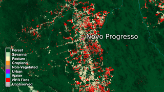
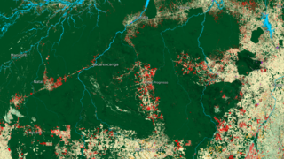
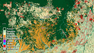
The Amazon has undergone major transformations throughout the past three decades (1985 - 2018). Working closely with their Brazilian counterparts, NASA scientists have mapped the entire country of Brazil to show different kinds of land use throughout the country. This data is based on the Landsat Data Continuity Mission (LDCM) through the MapBiomas project .
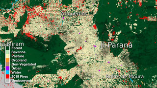
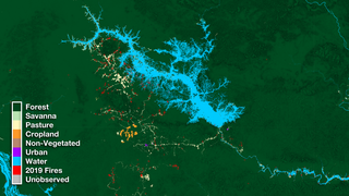
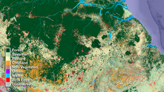
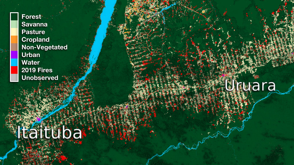
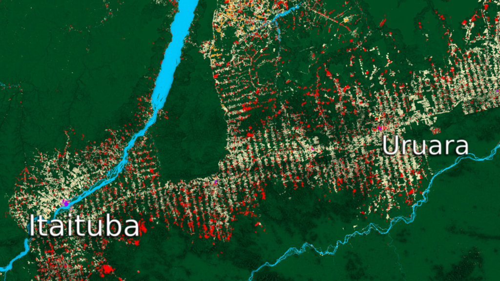
As part of this research, we look at the area between Itaituba and Urura and show how the land use changed from 1985 to 2018. 2019 fire data is also used to show controlled burns in order to clear cut forest areas for other use.

Itaituba and Uruara Land Use Data Over Time
As part of this research, we look at the area between Itaituba and Urura and show how the land use changed from 1985 to 2018. 2019 fire data is also used to show controlled burns in order to clear cut forest areas for other use.
Used Elsewhere In
Related

Visualization Credits
Alex Kekesi (Global Science and Technology, Inc.): Lead Data Visualizer
Matthew R. Radcliff (USRA): Lead Producer
Doug C. Morton (NASA/GSFC): Lead Scientist
Greg Shirah (NASA/GSFC): Data Visualizer
Niels Andela (Science Collaborator): Data Provider
Laurence Schuler (ADNET Systems, Inc.): Technical Support
Ian Jones (ADNET Systems, Inc.): Technical Support
Matthew R. Radcliff (USRA): Lead Producer
Doug C. Morton (NASA/GSFC): Lead Scientist
Greg Shirah (NASA/GSFC): Data Visualizer
Niels Andela (Science Collaborator): Data Provider
Laurence Schuler (ADNET Systems, Inc.): Technical Support
Ian Jones (ADNET Systems, Inc.): Technical Support
Please give credit for this item to:
NASA's Scientific Visualization Studio
NASA's Scientific Visualization Studio
Short URL to share this page:
https://svs.gsfc.nasa.gov/4832
Data Used:
Note: While we identify the data sets used in these visualizations, we do not store any further details nor the data sets themselves on our site.
Keywords:
DLESE >> Agricultural science
DLESE >> Biology
DLESE >> Environmental science
DLESE >> Forestry
DLESE >> Human geography
DLESE >> Hydrology
GCMD >> Earth Science >> Agriculture
GCMD >> Earth Science >> Agriculture >> Agricultural Engineering
GCMD >> Earth Science >> Agriculture >> Forest Science
GCMD >> Earth Science >> Agriculture >> Forest Science >> Forest Conservation
GCMD >> Earth Science >> Agriculture >> Forest Science >> Forest Harvesting and Engineering
GCMD >> Earth Science >> Agriculture >> Forest Science >> Forest Management
GCMD >> Earth Science >> Biosphere >> Terrestrial Ecosystems >> Agricultural Lands
GCMD >> Earth Science >> Biosphere >> Vegetation >> Forest Composition/Vegetation Structure
GCMD >> Earth Science >> Human Dimensions >> Environmental Impacts >> Agricultural Expansion
GCMD >> Earth Science >> Human Dimensions >> Environmental Impacts >> Urbanization
GCMD >> Earth Science >> Human Dimensions >> Habitat Conversion/Fragmentation >> Deforestation
GCMD >> Earth Science >> Hydrosphere >> Surface Water >> Water Channels
GCMD >> Earth Science >> Oceans >> Coastal Processes >> Mangroves
GCMD >> Location >> Brazil
GCMD >> Location >> Amazonia
SVS >> Hyperwall
NASA Science >> Earth
GCMD >> Earth Science >> Human Dimensions >> Habitat Conversion/fragmentation >> Urbanization/urban Sprawl
GCMD >> Earth Science >> Human Dimensions >> Human Settlements >> Urban Areas
GCMD keywords can be found on the Internet with the following citation: Olsen, L.M., G. Major, K. Shein, J. Scialdone, S. Ritz, T. Stevens, M. Morahan, A. Aleman, R. Vogel, S. Leicester, H. Weir, M. Meaux, S. Grebas, C.Solomon, M. Holland, T. Northcutt, R. A. Restrepo, R. Bilodeau, 2013. NASA/Global Change Master Directory (GCMD) Earth Science Keywords. Version 8.0.0.0.0
https://svs.gsfc.nasa.gov/4832
Data Used:
Suomi NPP/VIIRS/Fire Pixels
Analysis - NASA/GSFC - 2019MapBiomas also referred to as: Biomass Map
Analysis - MapBiomas Project - 1985-2018
MapBiomas Project is a multi-institutional initiative to generate annual land cover and use maps using automatic classification processes applied to satellite images.
Keywords:
DLESE >> Agricultural science
DLESE >> Biology
DLESE >> Environmental science
DLESE >> Forestry
DLESE >> Human geography
DLESE >> Hydrology
GCMD >> Earth Science >> Agriculture
GCMD >> Earth Science >> Agriculture >> Agricultural Engineering
GCMD >> Earth Science >> Agriculture >> Forest Science
GCMD >> Earth Science >> Agriculture >> Forest Science >> Forest Conservation
GCMD >> Earth Science >> Agriculture >> Forest Science >> Forest Harvesting and Engineering
GCMD >> Earth Science >> Agriculture >> Forest Science >> Forest Management
GCMD >> Earth Science >> Biosphere >> Terrestrial Ecosystems >> Agricultural Lands
GCMD >> Earth Science >> Biosphere >> Vegetation >> Forest Composition/Vegetation Structure
GCMD >> Earth Science >> Human Dimensions >> Environmental Impacts >> Agricultural Expansion
GCMD >> Earth Science >> Human Dimensions >> Environmental Impacts >> Urbanization
GCMD >> Earth Science >> Human Dimensions >> Habitat Conversion/Fragmentation >> Deforestation
GCMD >> Earth Science >> Hydrosphere >> Surface Water >> Water Channels
GCMD >> Earth Science >> Oceans >> Coastal Processes >> Mangroves
GCMD >> Location >> Brazil
GCMD >> Location >> Amazonia
SVS >> Hyperwall
NASA Science >> Earth
GCMD >> Earth Science >> Human Dimensions >> Habitat Conversion/fragmentation >> Urbanization/urban Sprawl
GCMD >> Earth Science >> Human Dimensions >> Human Settlements >> Urban Areas
GCMD keywords can be found on the Internet with the following citation: Olsen, L.M., G. Major, K. Shein, J. Scialdone, S. Ritz, T. Stevens, M. Morahan, A. Aleman, R. Vogel, S. Leicester, H. Weir, M. Meaux, S. Grebas, C.Solomon, M. Holland, T. Northcutt, R. A. Restrepo, R. Bilodeau, 2013. NASA/Global Change Master Directory (GCMD) Earth Science Keywords. Version 8.0.0.0.0


