Earth
ID: 4797
The Centre for Remote Environments, a research group within the Univ. of Dundee, Scotland's Duncanston-Jordan School of Art and Design, has been working with the South Georgia Island Heritage Trust, the Friends of South Georgia Island and the Govt. of South Georgia & the South Sandwich Islands, for many years on natural conservation and cultural preservation projects on South Georgia Island.
Recently, the South Georgia Heritage Trust had its annual meeting in Dundee, where a new not-for-profit conservation and cultural heritage app,"LIVE:SGI" was presented in demonstration form. Dr. Gary McKay, a former US Naval Research Laboratory scientist (and long-time NASA adjunct scientist) at NASA Stennis Space Center, MS, wanted to display a prototype visualisation of the unique land and seascape of South Georgia Island that might be used in a future app using both AR and VR forms.
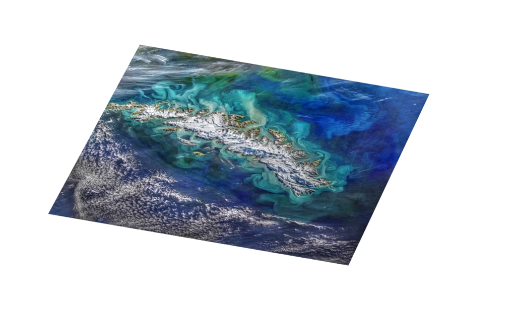
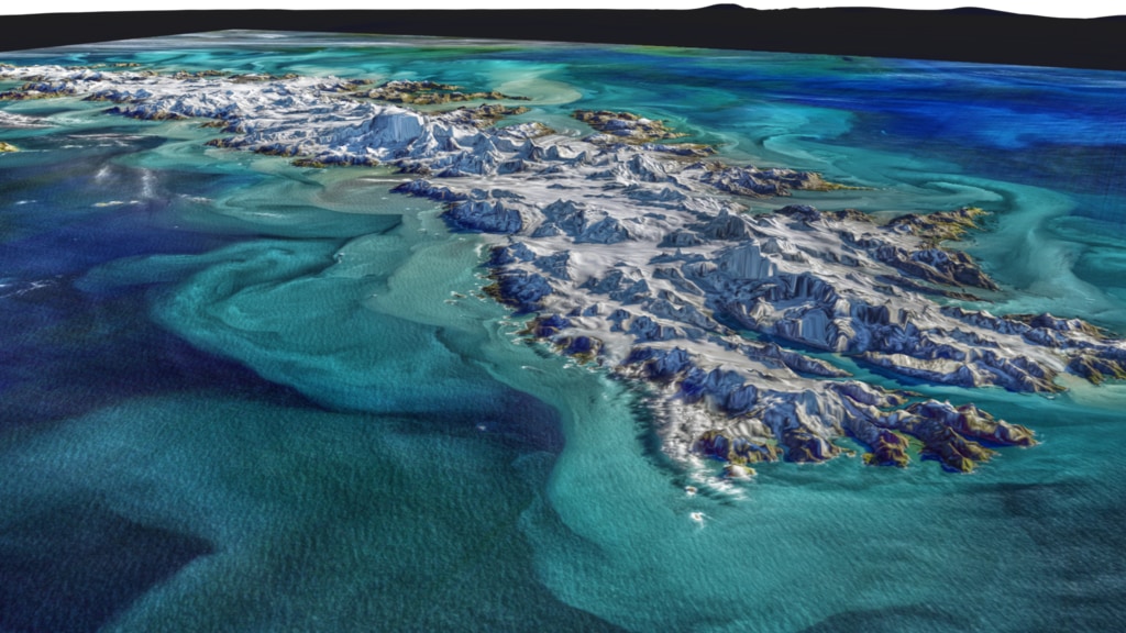
Using a Landsat-8 OLI image of South Georgia Island that was acquired on 2018 March 28 and processed by Norman Kuring. Greg Shirah of NASA/Goddard Space Flight Center's Scientific Visualization Studio (SVS) produced this "Space-to-Sea" visualization, or "fly-thru". It was presented at the annual South Georgia Island Heritage Trust conference and round-table meeting (26 Feb 2020), receiving resounding acclamation from all in attendance. A former member of the British Antarctic Survey who had worked on South Georgia Island in its remotest parts since the 1970s noted that, "this visualisation did more to show how South Georgia's unique landscape of sea-ending glaciers fed sediments and nutrients into the near and offshore currents around the island, than we had ever seen. The Centre for Remote Environments and the related South Georgia Island interest groups hope to collaborate in the future with the NASA Goddard SVS by supplying unique datasets from one of the most remote islands in the world for innovative ways of visualization."
South Georgia Island is a legendary small and mountainous island among travelers and historians. South Georgia Island served as the final stage in one of the greatest survival stories of all time: Ernest Shackleton's 1915 voyage to the southern seas aboard the Endurance. The crew of the Endurance had spent more than 18 months lost in the Antarctic, but they all survived the ordeal, largely thanks to the leadership of the boss, Ernest Shackleton.
To learn more about the Shackleton expedition, read the National Library of Scotland's feature article.
South Georgia Island Flyover
Recently, the South Georgia Heritage Trust had its annual meeting in Dundee, where a new not-for-profit conservation and cultural heritage app,"LIVE:SGI" was presented in demonstration form. Dr. Gary McKay, a former US Naval Research Laboratory scientist (and long-time NASA adjunct scientist) at NASA Stennis Space Center, MS, wanted to display a prototype visualisation of the unique land and seascape of South Georgia Island that might be used in a future app using both AR and VR forms.
Using a Landsat-8 OLI image of South Georgia Island that was acquired on 2018 March 28 and processed by Norman Kuring. Greg Shirah of NASA/Goddard Space Flight Center's Scientific Visualization Studio (SVS) produced this "Space-to-Sea" visualization, or "fly-thru". It was presented at the annual South Georgia Island Heritage Trust conference and round-table meeting (26 Feb 2020), receiving resounding acclamation from all in attendance. A former member of the British Antarctic Survey who had worked on South Georgia Island in its remotest parts since the 1970s noted that, "this visualisation did more to show how South Georgia's unique landscape of sea-ending glaciers fed sediments and nutrients into the near and offshore currents around the island, than we had ever seen. The Centre for Remote Environments and the related South Georgia Island interest groups hope to collaborate in the future with the NASA Goddard SVS by supplying unique datasets from one of the most remote islands in the world for innovative ways of visualization."
South Georgia Island is a legendary small and mountainous island among travelers and historians. South Georgia Island served as the final stage in one of the greatest survival stories of all time: Ernest Shackleton's 1915 voyage to the southern seas aboard the Endurance. The crew of the Endurance had spent more than 18 months lost in the Antarctic, but they all survived the ordeal, largely thanks to the leadership of the boss, Ernest Shackleton.
To learn more about the Shackleton expedition, read the National Library of Scotland's feature article.
Visualization Credits
Greg Shirah (NASA/GSFC): Lead Visualizer
Gene Feldman (NASA/GSFC): Scientist
Norman Kuring (NASA/GSFC): Scientist
Laurence Schuler (ADNET Systems, Inc.): Technical Support
Ian Jones (ADNET Systems, Inc.): Technical Support
Gene Feldman (NASA/GSFC): Scientist
Norman Kuring (NASA/GSFC): Scientist
Laurence Schuler (ADNET Systems, Inc.): Technical Support
Ian Jones (ADNET Systems, Inc.): Technical Support
Please give credit for this item to:
NASA's Scientific Visualization Studio
NASA's Scientific Visualization Studio
Short URL to share this page:
https://svs.gsfc.nasa.gov/4797
Mission:
Landsat 8
Data Used:
Note: While we identify the data sets used in these visualizations, we do not store any further details nor the data sets themselves on our site.
This item is part of this series:
Landsat
Keywords:
SVS >> Landsat
DLESE >> Physical geography
GCMD >> Earth Science >> Land Surface >> Topography
SVS >> Hyperwall
NASA Science >> Earth
GCMD keywords can be found on the Internet with the following citation: Olsen, L.M., G. Major, K. Shein, J. Scialdone, S. Ritz, T. Stevens, M. Morahan, A. Aleman, R. Vogel, S. Leicester, H. Weir, M. Meaux, S. Grebas, C.Solomon, M. Holland, T. Northcutt, R. A. Restrepo, R. Bilodeau, 2013. NASA/Global Change Master Directory (GCMD) Earth Science Keywords. Version 8.0.0.0.0
https://svs.gsfc.nasa.gov/4797
Mission:
Landsat 8
Data Used:
SRTM/SIR-C/DEM
Terra and Aqua/MODIS/Blue Marble: Next Generation also referred to as: BMNG
Credit:
The Blue Marble data is courtesy of Reto Stockli (NASA/GSFC).
The Blue Marble data is courtesy of Reto Stockli (NASA/GSFC).
2-minute Gridded Global Relief Data also referred to as: ETOPO2
Data Compilation - NOAA NGDCLansdat-8
Observed Data - USGS - 03/28/2018This item is part of this series:
Landsat
Keywords:
SVS >> Landsat
DLESE >> Physical geography
GCMD >> Earth Science >> Land Surface >> Topography
SVS >> Hyperwall
NASA Science >> Earth
GCMD keywords can be found on the Internet with the following citation: Olsen, L.M., G. Major, K. Shein, J. Scialdone, S. Ritz, T. Stevens, M. Morahan, A. Aleman, R. Vogel, S. Leicester, H. Weir, M. Meaux, S. Grebas, C.Solomon, M. Holland, T. Northcutt, R. A. Restrepo, R. Bilodeau, 2013. NASA/Global Change Master Directory (GCMD) Earth Science Keywords. Version 8.0.0.0.0


