Planets and Moons
ID: 4731
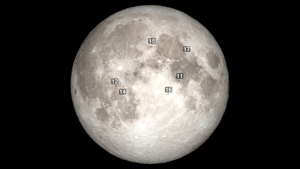
The NASA Apollo missions landed at six sites on the Moon between 1969 and 1972. As seen in this visualization, all of the sites are near the equator on the near side (the side facing the Earth), and all of the landings took place fairly soon after local sunrise, when the lunar surface was cool and the shadows threw the terrain into high relief, making navigation easier.
Between each landing, the Moon is shown going through its monthly cycle of phases. The time between landings is especially long between Apollo 12 and 14, since Apollo 13 suffered a major equipment failure and was unable to land. The text includes the total number of hours that the Lunar Module (LM, pronounced "lem") was on the surface along with the number of hours that the astronauts were actually outside — extravehicular activity or EVA in astronaut speak.
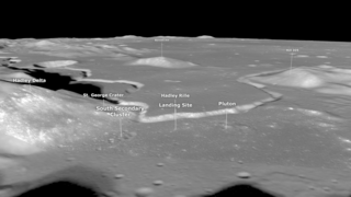
The precise landing site coordinates are those recently determined from Lunar Reconnaissance Orbiter (LRO) narrow angle camera images of the sites. The coordinates are listed here and in
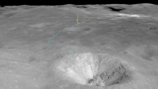
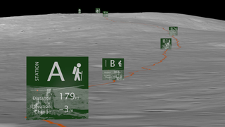
The amount of time that the astronauts were able to stay on the surface increased with each mission. Distance traveled during EVAs on the last three missions were greatly extended by a lunar rover, a battery-powered dune buggy that allowed the astronauts to visit and sample places several kilometers away from the LM.

Apollo Landing Sites with Moon Phases
Between each landing, the Moon is shown going through its monthly cycle of phases. The time between landings is especially long between Apollo 12 and 14, since Apollo 13 suffered a major equipment failure and was unable to land. The text includes the total number of hours that the Lunar Module (LM, pronounced "lem") was on the surface along with the number of hours that the astronauts were actually outside — extravehicular activity or EVA in astronaut speak.
The precise landing site coordinates are those recently determined from Lunar Reconnaissance Orbiter (LRO) narrow angle camera images of the sites. The coordinates are listed here and in
Coordinates of anthropogenic features on the Moonby Wagner et al. in the February, 2017 Icarus. The surface times are from Apollo by the Numbers by Orloff. Also see the Apollo Lunar Surface Journal, a complete and thoroughly annotated transcript of astronaut activities on the Moon.
The amount of time that the astronauts were able to stay on the surface increased with each mission. Distance traveled during EVAs on the last three missions were greatly extended by a lunar rover, a battery-powered dune buggy that allowed the astronauts to visit and sample places several kilometers away from the LM.
Related


Visualization Credits
Please give credit for this item to:
NASA's Scientific Visualization Studio
NASA's Scientific Visualization Studio
Short URL to share this page:
https://svs.gsfc.nasa.gov/4731
Data Used:
Note: While we identify the data sets used in these visualizations, we do not store any further details nor the data sets themselves on our site.
This item is part of this series:
The Moon
Keywords:
SVS >> HDTV
SVS >> Landing Site
SVS >> Moon
SVS >> Hyperwall
SVS >> LRO
SVS >> Lunar Reconnaissance Orbiter
SVS >> Apollo Missions
NASA Science >> Planets and Moons
https://svs.gsfc.nasa.gov/4731
Data Used:
LRO/LOLA/Digital Elevation Map also referred to as: DEM
Lunar Reconnaissance Orbiter/LRO Camera/Natural Color Hapke Normalized WAC Mosaic also referred to as: LROC WAC Color Mosaic
Mosaic - Arizona State University
This natural-color global mosaic is based on the 'Hapke normalized' mosaic from LRO's wide-angle camera. The data has been gamma corrected, white balanced, and range adjusted to more closely match human vision.
This item is part of this series:
The Moon
Keywords:
SVS >> HDTV
SVS >> Landing Site
SVS >> Moon
SVS >> Hyperwall
SVS >> LRO
SVS >> Lunar Reconnaissance Orbiter
SVS >> Apollo Missions
NASA Science >> Planets and Moons


