Earth
ID: 4590
When a giant swell of warm water, known as El Niño emerged in the Pacific Ocean in 2015, scientists knew to look for impacts. As El Niño changed global weather patterns Southern Africa went into severe drought. On top of already dry conditions, the region experienced its lowest rainfall in 35 years.
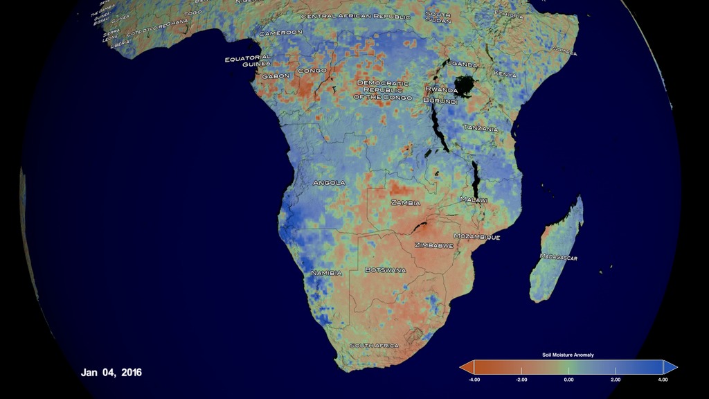
With the Soil Moisture Active Passive (SMAP) mission, launched in 2015, NASA has dedicated soil moisture measurements for the first time – and could see this severe drought emerging. SMAP's highly sensitive microwave radiometer detects the energy emitted by soil depending on how wet or how dry it is. The old gardener's trick is to squeeze a handful of dirt in your hand and see whether it clumps or falls apart. Think of SMAP doing the same thing – with a lot more precision, all around the world, every 3 days.
SMAP allowed us to see a connection between Pacific Ocean water temperatures and the moisture of the soil in Southern Africa. These measurements are now being put to operational use more than ever. SMAP's data was fed into the USDA's global crop yield forecasts – the Foreign Agriculture Service reports that help drive multi-billion dollar commodity markets around the world. In fact, the Foreign Ag Service scientist for this region said that with SMAP they now have the first reliable soil moisture data in 30 years.
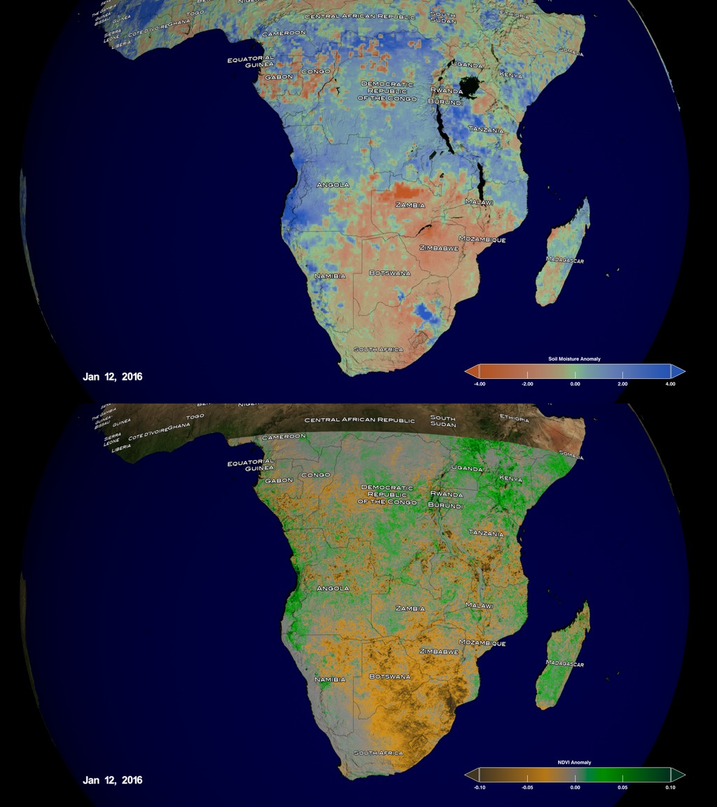
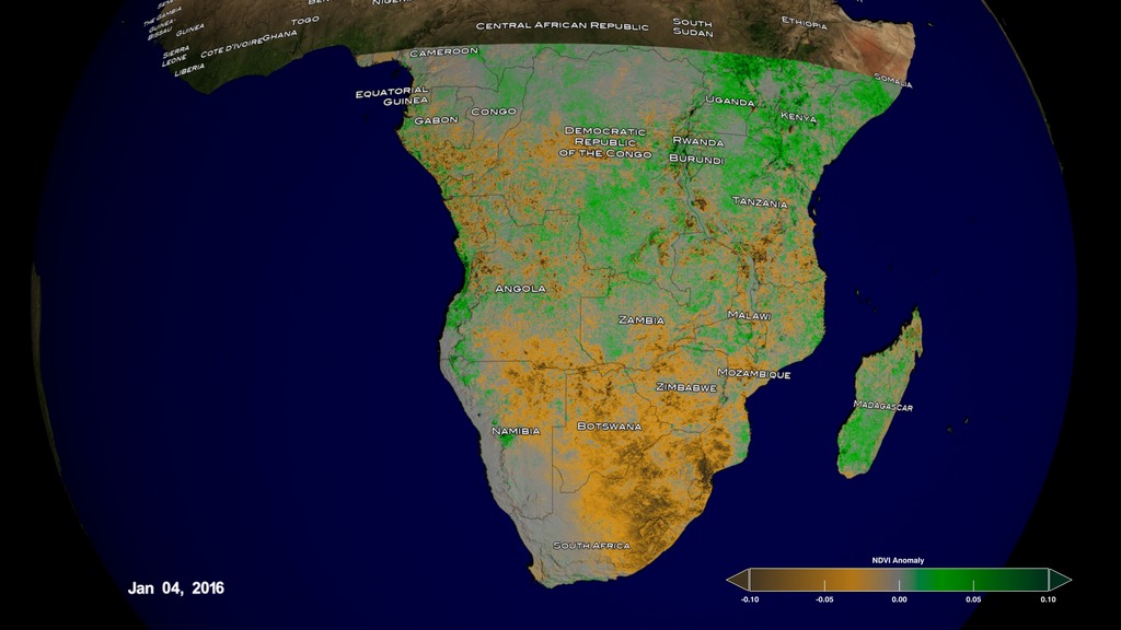
As crops failed and soils were left bare, we used the Terra and Aqua satellites to assess these effects on the vegetation from a local to regional scale. The Normalized Differential Vegetation Index (NDVI) reflects the health of vegetation on the land surface.
As this drought spread across Southern Africa, nearly 30 million people were at risk of drastic food shortages. Four out of 10 people did not have access to clean drinking water.
The analyses and data provided by NASA scientists are also critical to a USAID program called the Famine Early Warning Systems Network. As food crises arise, the global view provided by NASA scientists informs decisions about where governments and relief agencies should send help.
In Southern Africa in 2015 and 2016, nearly 350 million dollars of emergency water and food aid were delivered, in part based on NASA data, to aid millions of people.
As the peak of the drought hits in January 2016, the animations show the low soil moisture conditions in Zambia, Zimbabwe, and Botswana. Correspondingly the low vegetation appears in that region as well.

Southern Africa Drought
With the Soil Moisture Active Passive (SMAP) mission, launched in 2015, NASA has dedicated soil moisture measurements for the first time – and could see this severe drought emerging. SMAP's highly sensitive microwave radiometer detects the energy emitted by soil depending on how wet or how dry it is. The old gardener's trick is to squeeze a handful of dirt in your hand and see whether it clumps or falls apart. Think of SMAP doing the same thing – with a lot more precision, all around the world, every 3 days.
SMAP allowed us to see a connection between Pacific Ocean water temperatures and the moisture of the soil in Southern Africa. These measurements are now being put to operational use more than ever. SMAP's data was fed into the USDA's global crop yield forecasts – the Foreign Agriculture Service reports that help drive multi-billion dollar commodity markets around the world. In fact, the Foreign Ag Service scientist for this region said that with SMAP they now have the first reliable soil moisture data in 30 years.
As crops failed and soils were left bare, we used the Terra and Aqua satellites to assess these effects on the vegetation from a local to regional scale. The Normalized Differential Vegetation Index (NDVI) reflects the health of vegetation on the land surface.
As this drought spread across Southern Africa, nearly 30 million people were at risk of drastic food shortages. Four out of 10 people did not have access to clean drinking water.
The analyses and data provided by NASA scientists are also critical to a USAID program called the Famine Early Warning Systems Network. As food crises arise, the global view provided by NASA scientists informs decisions about where governments and relief agencies should send help.
In Southern Africa in 2015 and 2016, nearly 350 million dollars of emergency water and food aid were delivered, in part based on NASA data, to aid millions of people.
As the peak of the drought hits in January 2016, the animations show the low soil moisture conditions in Zambia, Zimbabwe, and Botswana. Correspondingly the low vegetation appears in that region as well.
Visualization Credits
Cheng Zhang (USRA): Lead Visualizer
Horace Mitchell (NASA/GSFC): Visualizer
Lori Perkins (NASA/GSFC): Visualizer
Matthew R. Radcliff (USRA): Lead Producer
Christa Peters-Lidard (NASA/GSFC): Lead Scientist
Horace Mitchell (NASA/GSFC): Visualizer
Lori Perkins (NASA/GSFC): Visualizer
Matthew R. Radcliff (USRA): Lead Producer
Christa Peters-Lidard (NASA/GSFC): Lead Scientist
Please give credit for this item to:
NASA's Scientific Visualization Studio
NASA's Scientific Visualization Studio
Short URL to share this page:
https://svs.gsfc.nasa.gov/4590
Data Used:
Note: While we identify the data sets used in these visualizations, we do not store any further details nor the data sets themselves on our site.
Keywords:
SVS >> Drought
SVS >> Hyperwall
SVS >> Weather >> Seasons >> Vegetation Growth
SVS >> Seasons >> Vegetation
NASA Science >> Earth
GCMD >> Earth Science >> Climate Indicators >> Land Surface/agriculture Indicators >> Vegetation Cover
GCMD keywords can be found on the Internet with the following citation: Olsen, L.M., G. Major, K. Shein, J. Scialdone, S. Ritz, T. Stevens, M. Morahan, A. Aleman, R. Vogel, S. Leicester, H. Weir, M. Meaux, S. Grebas, C.Solomon, M. Holland, T. Northcutt, R. A. Restrepo, R. Bilodeau, 2013. NASA/Global Change Master Directory (GCMD) Earth Science Keywords. Version 8.0.0.0.0
https://svs.gsfc.nasa.gov/4590
Data Used:
GTOPO30 Topography and Bathymetry
Data Compilation - USGSTerra and Aqua/MODIS/Blue Marble: Next Generation also referred to as: BMNG
Credit:
The Blue Marble data is courtesy of Reto Stockli (NASA/GSFC).
The Blue Marble data is courtesy of Reto Stockli (NASA/GSFC).
Terra and Aqua/MODIS/Normalized Difference Vegetation Index (NDVI) also referred to as: NDVI
NASASurface Soil Moisture corrected with SMOS imagery and assimilated by the Ensemble Kalman Filter also referred to as: NASA-USDA-FAS Soil Moisture
Data Compilation - NASA and USDA
The surface soil moisture product is corrected by integrating satellite-derived Soil Moisture Ocean Salinity (SMOS) mission surface soil moisture retrievals into the modified Palmer two-layer soil moisture model. The SMOS imagery helps to correct the modified Pal
Keywords:
SVS >> Drought
SVS >> Hyperwall
SVS >> Weather >> Seasons >> Vegetation Growth
SVS >> Seasons >> Vegetation
NASA Science >> Earth
GCMD >> Earth Science >> Climate Indicators >> Land Surface/agriculture Indicators >> Vegetation Cover
GCMD keywords can be found on the Internet with the following citation: Olsen, L.M., G. Major, K. Shein, J. Scialdone, S. Ritz, T. Stevens, M. Morahan, A. Aleman, R. Vogel, S. Leicester, H. Weir, M. Meaux, S. Grebas, C.Solomon, M. Holland, T. Northcutt, R. A. Restrepo, R. Bilodeau, 2013. NASA/Global Change Master Directory (GCMD) Earth Science Keywords. Version 8.0.0.0.0


