Earth
ID: 4194
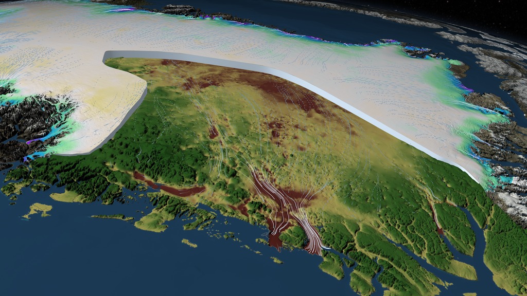
This animation depicts the changes in the Greenland Ice Sheet between 2003 and 2012 and shows how the bedrock topography under the ice constrains or facilitates its movement. This is a subset of a longer, narrated animation that can be found here.
The surface elevation1 and the bedrock topography2 are defined by geo-referenced DEM datasets. The change in elevation data3 derived from data collected by NASA’s ICESat satellite and from an airborne mission called Operation IceBridge is portrayed as colors accumulating over time on the surface. A cutting plane is used to reveal the thickness of the ice sheet and the bedrock topography beneath. A dataset of ice sheet velocity4 derived from from satellite interferometry is used to define the motion of the ice sheet over time. Ice flow movement is calculated from this velocity data, colored by the speed of the ice, and propagated over the surface of the ice sheet.
This visualization was generated using Maya, Renderman and IDL. Over the years, we developed some tools to facilitate visualizing data. These include manifolds that accurately project data onto a sphere, routines to accurately access the correct data texture in a series based on the date keyframed in a Maya scene and a flow system that propagates flow vectors at any given time step and inserts the results directly into the RIB stream at render time. These tools are a credit to the director of our studio, Dr. Horace Mitchell and my colleague Greg Shirah.
1. Greenland Mapping Project (GIMP) Digital Elevation Model provided courtesy of the BPRC Glacier Dynamics Research Group, Ohio State University
2. Greenland bed elevation provided courtesy of J. L. Bamber, Univesity of Bristol.
3. Elevation Change data provided courtesy of Bea Csatho, University at Buffalo.
4. Ice Sheet Velocity data provided courtesy of Eric Rignot, University of California, Irvine.
SIGGRAPH Daily 2014: Measuring Elevation Changes on the Greenland Ice Sheet
The surface elevation1 and the bedrock topography2 are defined by geo-referenced DEM datasets. The change in elevation data3 derived from data collected by NASA’s ICESat satellite and from an airborne mission called Operation IceBridge is portrayed as colors accumulating over time on the surface. A cutting plane is used to reveal the thickness of the ice sheet and the bedrock topography beneath. A dataset of ice sheet velocity4 derived from from satellite interferometry is used to define the motion of the ice sheet over time. Ice flow movement is calculated from this velocity data, colored by the speed of the ice, and propagated over the surface of the ice sheet.
This visualization was generated using Maya, Renderman and IDL. Over the years, we developed some tools to facilitate visualizing data. These include manifolds that accurately project data onto a sphere, routines to accurately access the correct data texture in a series based on the date keyframed in a Maya scene and a flow system that propagates flow vectors at any given time step and inserts the results directly into the RIB stream at render time. These tools are a credit to the director of our studio, Dr. Horace Mitchell and my colleague Greg Shirah.
1. Greenland Mapping Project (GIMP) Digital Elevation Model provided courtesy of the BPRC Glacier Dynamics Research Group, Ohio State University
2. Greenland bed elevation provided courtesy of J. L. Bamber, Univesity of Bristol.
3. Elevation Change data provided courtesy of Bea Csatho, University at Buffalo.
4. Ice Sheet Velocity data provided courtesy of Eric Rignot, University of California, Irvine.
Visualization Credits
Cindy Starr (Global Science and Technology, Inc.): Lead Visualizer
Horace Mitchell (NASA/GSFC): Animator
Greg Shirah (NASA/GSFC): Animator
Laurence Schuler (ADNET Systems, Inc.): Project Support
Ian Jones (ADNET Systems, Inc.): Project Support
Horace Mitchell (NASA/GSFC): Animator
Greg Shirah (NASA/GSFC): Animator
Laurence Schuler (ADNET Systems, Inc.): Project Support
Ian Jones (ADNET Systems, Inc.): Project Support
Please give credit for this item to:
NASA's Scientific Visualization Studio
NASA's Scientific Visualization Studio
Short URL to share this page:
https://svs.gsfc.nasa.gov/4194
Keywords:
SVS >> HDTV
NASA Science >> Earth
https://svs.gsfc.nasa.gov/4194
Keywords:
SVS >> HDTV
NASA Science >> Earth


