Earth
ID: 4007
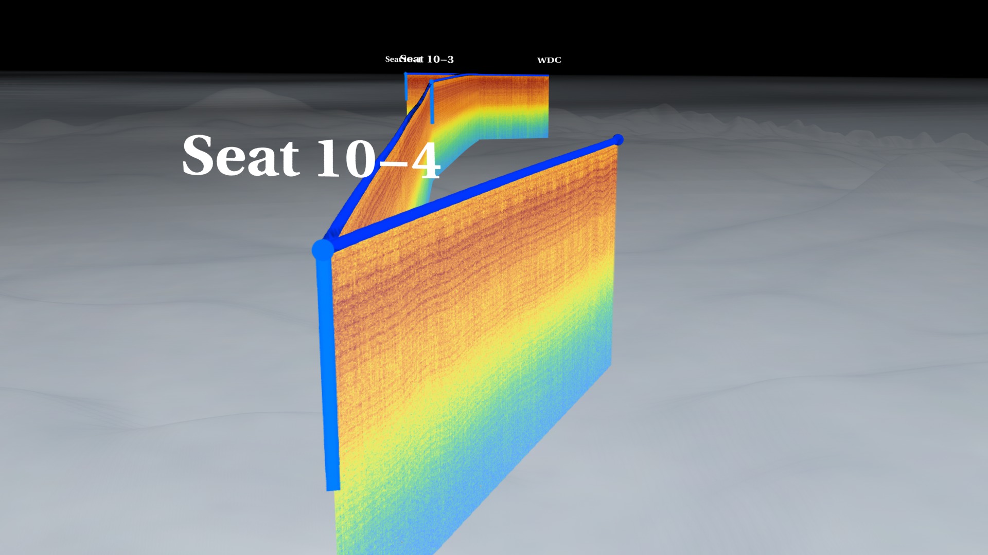
This visualization presents data collected by the 2010 Satellite Era Accumulation Traverse (SEAT).
Accumulation, the amount of snow that falls on an ice sheet, is one of the most important inputs for determining the mass balance of an ice sheet. There are, however, relatively few direct accumulation measurements because the most precise measurements come from ice cores at a single point location.
Recently, new large-bandwidth, very-high frequency radars have been developed and used over the ice sheets to image internal layers in the near surface which represent about the past 30-40 years of accumulation. The SEAT traverses are making the link between near surface radar layers and ice cores by collecting both simultaneously across the West Antarctic Ice Sheet Divide region.
Ground-Penetrating Radar Measurements of Antarctic Ice Sheet
Accumulation, the amount of snow that falls on an ice sheet, is one of the most important inputs for determining the mass balance of an ice sheet. There are, however, relatively few direct accumulation measurements because the most precise measurements come from ice cores at a single point location.
Recently, new large-bandwidth, very-high frequency radars have been developed and used over the ice sheets to image internal layers in the near surface which represent about the past 30-40 years of accumulation. The SEAT traverses are making the link between near surface radar layers and ice cores by collecting both simultaneously across the West Antarctic Ice Sheet Divide region.
Visualization Credits
Trent L. Schindler (USRA): Lead Animator
Jefferson Beck (USRA): Producer
Lora Koenig (NASA/GSFC): Scientist
Jefferson Beck (USRA): Producer
Lora Koenig (NASA/GSFC): Scientist
Please give credit for this item to:
NASA's Goddard Space Flight Center Scientific Visualization Studio
NASA's Goddard Space Flight Center Scientific Visualization Studio
Short URL to share this page:
https://svs.gsfc.nasa.gov/4007
Data Used:
Note: While we identify the data sets used in these visualizations, we do not store any further details nor the data sets themselves on our site.
Keywords:
SVS >> Antarctic
SVS >> Antarctic Ice
SVS >> Antarctic Ice Sheet
SVS >> HDTV
GCMD >> Earth Science >> Spectral/Engineering >> Radar >> Radar Imagery
NASA Science >> Earth
GCMD keywords can be found on the Internet with the following citation: Olsen, L.M., G. Major, K. Shein, J. Scialdone, S. Ritz, T. Stevens, M. Morahan, A. Aleman, R. Vogel, S. Leicester, H. Weir, M. Meaux, S. Grebas, C.Solomon, M. Holland, T. Northcutt, R. A. Restrepo, R. Bilodeau, 2013. NASA/Global Change Master Directory (GCMD) Earth Science Keywords. Version 8.0.0.0.0
https://svs.gsfc.nasa.gov/4007
Data Used:
Snowmobile/Radar also referred to as: SEAT
Keywords:
SVS >> Antarctic
SVS >> Antarctic Ice
SVS >> Antarctic Ice Sheet
SVS >> HDTV
GCMD >> Earth Science >> Spectral/Engineering >> Radar >> Radar Imagery
NASA Science >> Earth
GCMD keywords can be found on the Internet with the following citation: Olsen, L.M., G. Major, K. Shein, J. Scialdone, S. Ritz, T. Stevens, M. Morahan, A. Aleman, R. Vogel, S. Leicester, H. Weir, M. Meaux, S. Grebas, C.Solomon, M. Holland, T. Northcutt, R. A. Restrepo, R. Bilodeau, 2013. NASA/Global Change Master Directory (GCMD) Earth Science Keywords. Version 8.0.0.0.0


