Earth
ID: 3791
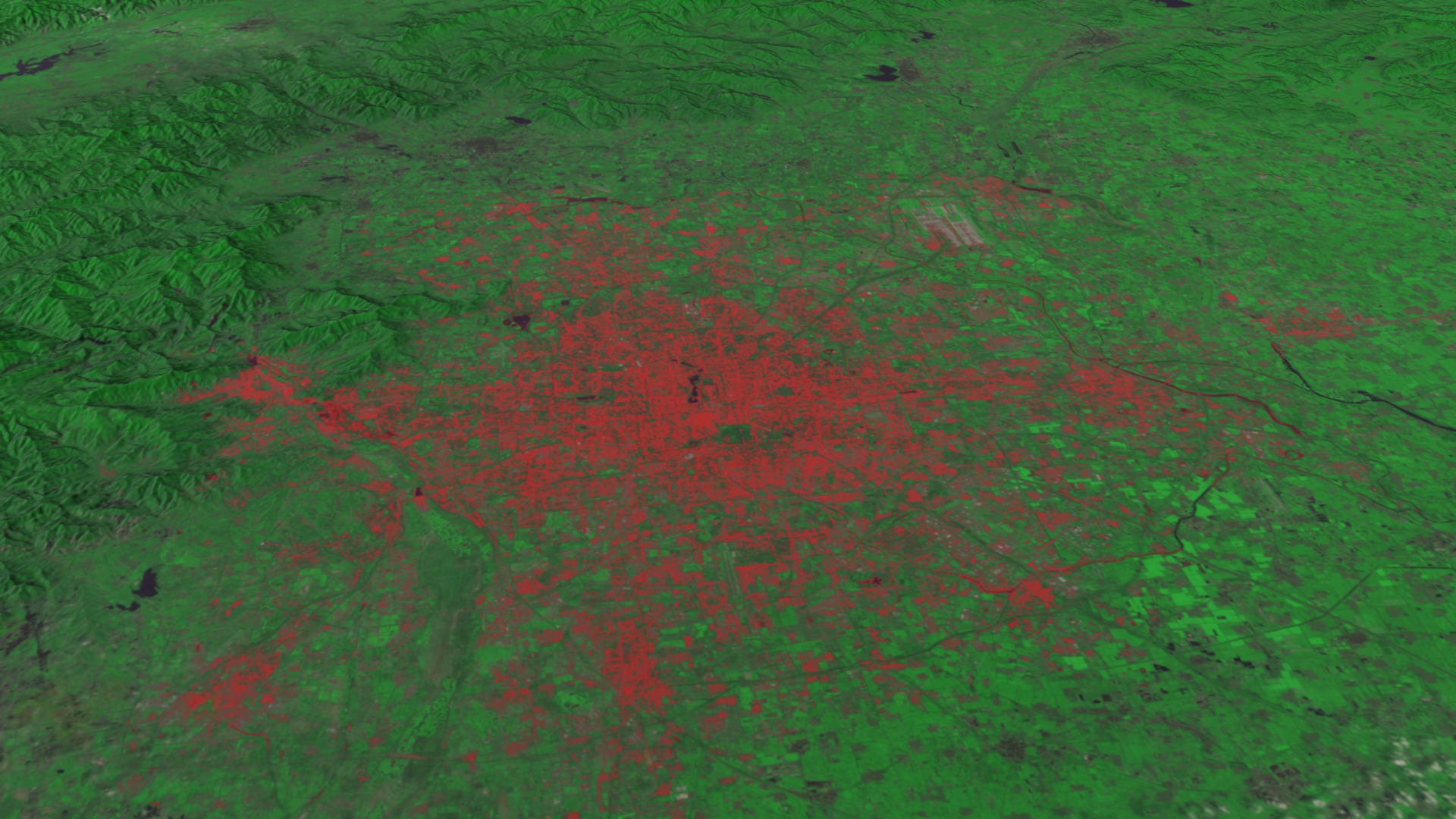
Beijing is one of the oldest, and now, one of the most crowded cities in the world. Established as a city in 1045 BC, King Wu was the first to declare it as a capital in 1057 BC. Having served as the capital of the Liao, Jin, Yuan, Ming and Qing Dynasties, Beijing is now the capital of the People's Republic of China. In these Landsat images, the explosive growth of this ancient city is clearly visible. In 1972, only about 7.89 million people lived there — but by 2010 the population swelled to more than 12 million. This increase in the city's size corresponds to the opening of China to the Western world in the 1970s. Up until 1979, the government restricted housing in the city, limiting it to the confines of the "Outer City." Previously a walled fortress, its outline is still visible today due to the build up of canals and roads along the path of the original wall. Inside this rectangular boundary is the ancient heart of the capital, the moat-lined Forbidden City. Called forbidden because anyone entering needed royal permission, this is where the Imperial Palace still stands, once home to 500 years of Chinese emperors. It was Kublai Khan who established the Forbidden City in 1260 A.D. He called it Khanbaliq but Italian explorer Marco Polo called it Cambuluc. It still stands as Beijing's city center. In 1421 the Chinese took the city back and gave it its current name of Beijing. Today, Beijing is only limited by the rugged Taihang Mountains that run to the west and northwest of the city, pushing the population to spread to the south and east across the relatively flat coastal plain.
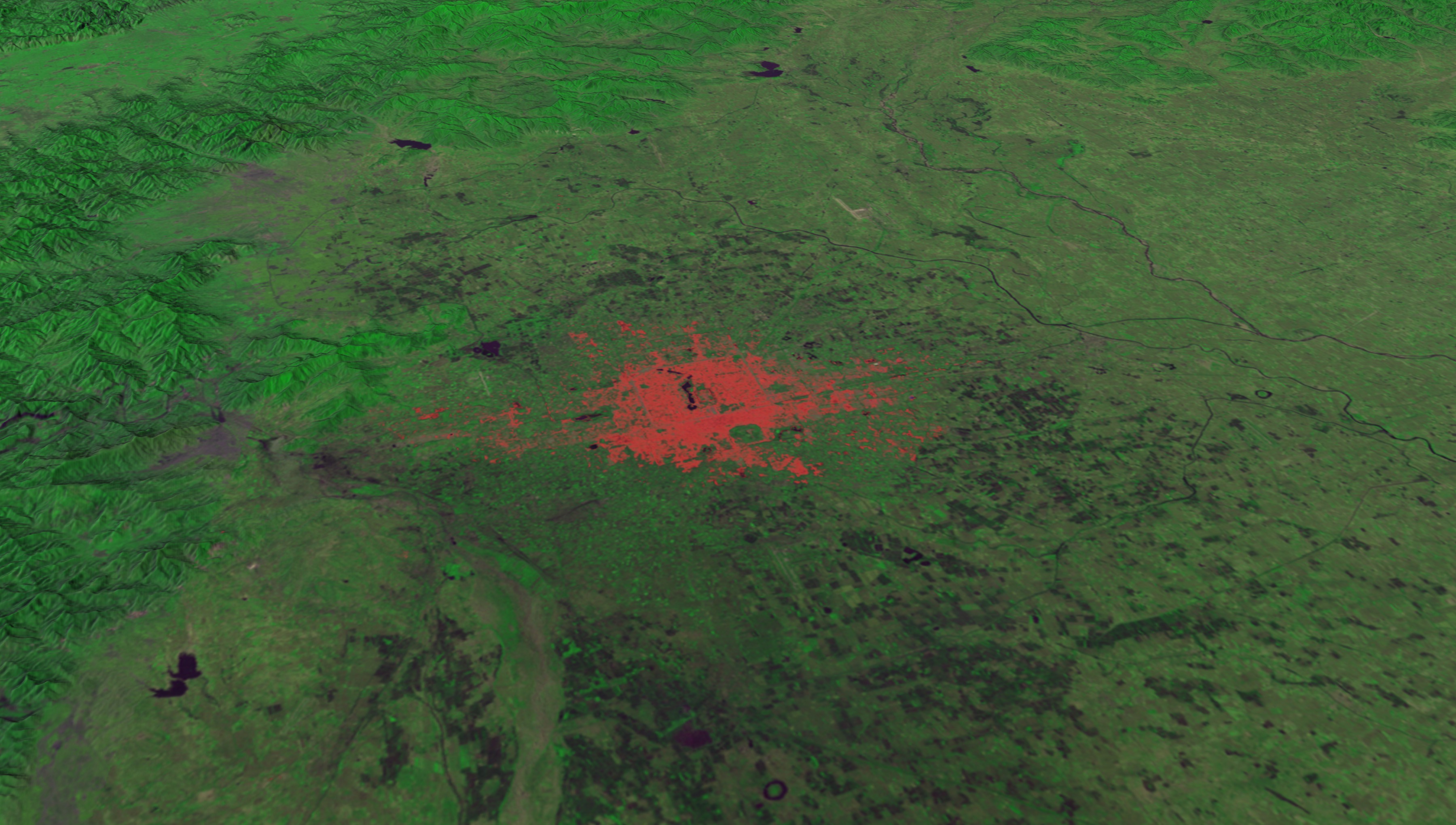
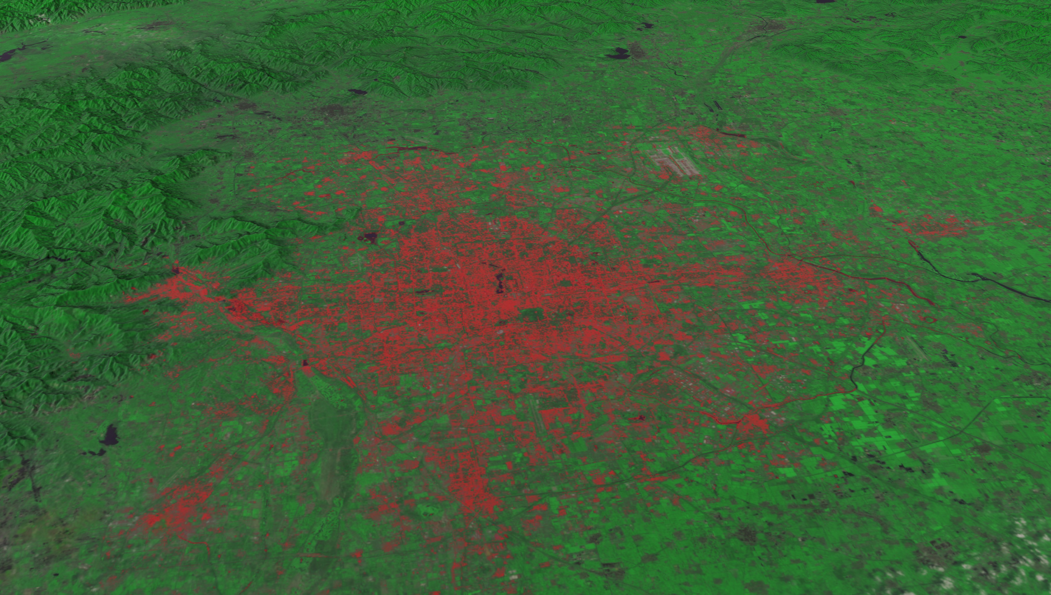
Urban Sprawl in Beijing, China
Visualization Credits
Alex Kekesi (Global Science and Technology, Inc.): Lead Animator
Horace Mitchell (NASA/GSFC): Animator
Matthew R. Radcliff (USRA): Producer
Laurence Schuler (ADNET Systems, Inc.): Project Support
Ian Jones (ADNET Systems, Inc.): Project Support
Aries Keck (ADNET Systems, Inc.): Writer
Horace Mitchell (NASA/GSFC): Animator
Matthew R. Radcliff (USRA): Producer
Laurence Schuler (ADNET Systems, Inc.): Project Support
Ian Jones (ADNET Systems, Inc.): Project Support
Aries Keck (ADNET Systems, Inc.): Writer
Please give credit for this item to:
NASA/Goddard Space Flight Center Scientific Visualization Studio
NASA/Goddard Space Flight Center Scientific Visualization Studio
Short URL to share this page:
https://svs.gsfc.nasa.gov/3791
Missions:
Landsat
LDCM: Landsat Data Continuity Mission
Data Used:
Note: While we identify the data sets used in these visualizations, we do not store any further details nor the data sets themselves on our site.
This item is part of this series:
LDCM
Keywords:
SVS >> HDTV
SVS >> Landsat
SVS >> Sprawl
SVS >> Urban
SVS >> Urban Growth
GCMD >> Earth Science >> Human Dimensions >> Environmental Impacts >> Urbanization
GCMD >> Location >> China
SVS >> LDCM
NASA Science >> Earth
GCMD >> Earth Science >> Human Dimensions >> Habitat Conversion/fragmentation >> Urbanization/urban Sprawl
GCMD keywords can be found on the Internet with the following citation: Olsen, L.M., G. Major, K. Shein, J. Scialdone, S. Ritz, T. Stevens, M. Morahan, A. Aleman, R. Vogel, S. Leicester, H. Weir, M. Meaux, S. Grebas, C.Solomon, M. Holland, T. Northcutt, R. A. Restrepo, R. Bilodeau, 2013. NASA/Global Change Master Directory (GCMD) Earth Science Keywords. Version 8.0.0.0.0
https://svs.gsfc.nasa.gov/3791
Missions:
Landsat
LDCM: Landsat Data Continuity Mission
Data Used:
Landsat-3/MSS/Band Combination 5, 7, 4
6/21/1978Landsat-5/TM/Band Combination 3, 4, 2
8/8/2010This item is part of this series:
LDCM
Keywords:
SVS >> HDTV
SVS >> Landsat
SVS >> Sprawl
SVS >> Urban
SVS >> Urban Growth
GCMD >> Earth Science >> Human Dimensions >> Environmental Impacts >> Urbanization
GCMD >> Location >> China
SVS >> LDCM
NASA Science >> Earth
GCMD >> Earth Science >> Human Dimensions >> Habitat Conversion/fragmentation >> Urbanization/urban Sprawl
GCMD keywords can be found on the Internet with the following citation: Olsen, L.M., G. Major, K. Shein, J. Scialdone, S. Ritz, T. Stevens, M. Morahan, A. Aleman, R. Vogel, S. Leicester, H. Weir, M. Meaux, S. Grebas, C.Solomon, M. Holland, T. Northcutt, R. A. Restrepo, R. Bilodeau, 2013. NASA/Global Change Master Directory (GCMD) Earth Science Keywords. Version 8.0.0.0.0


