Earth
ID: 3779
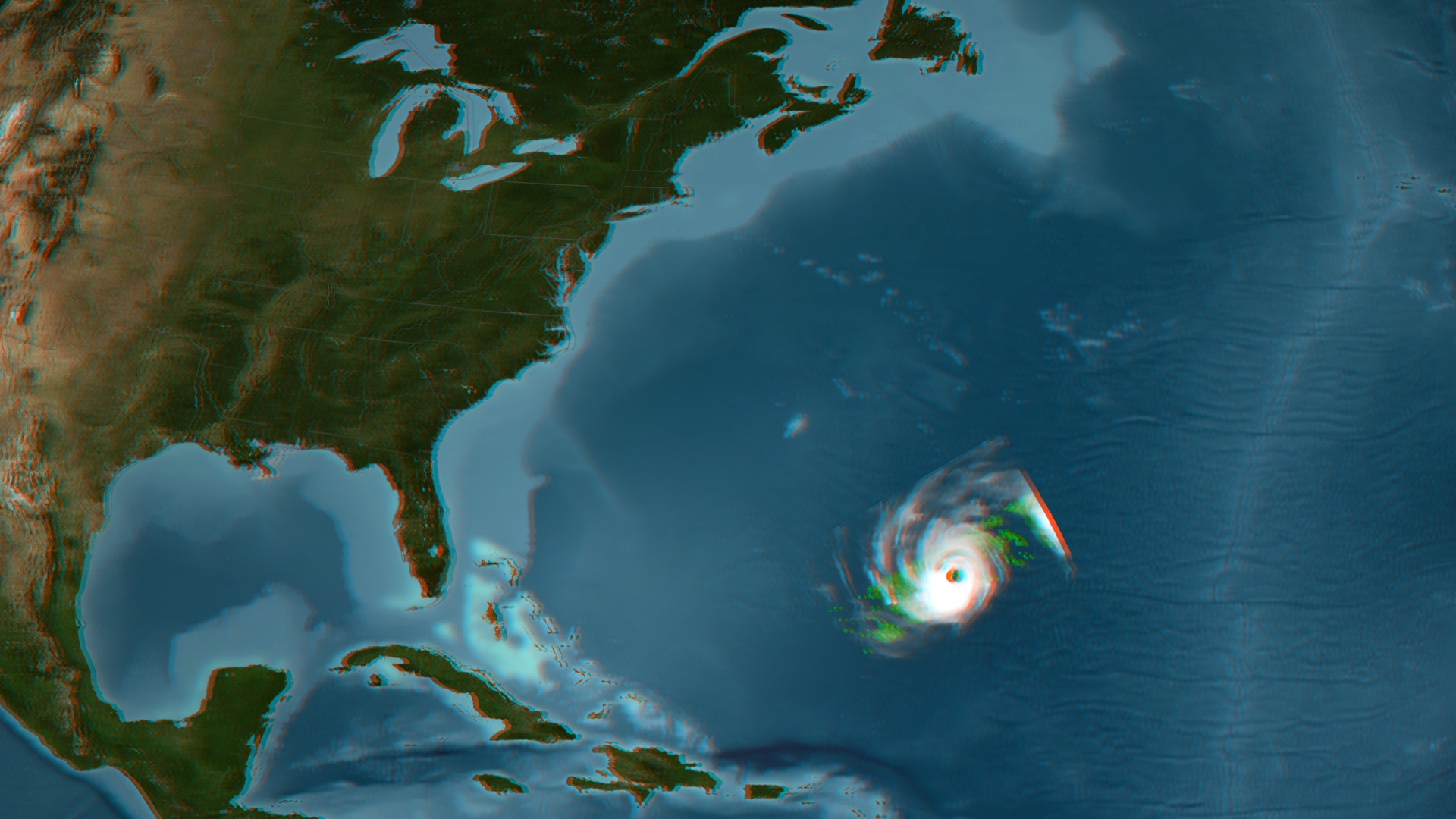
NASA's TRMM spacecraft allows us to look under Hurricane Danielle's clouds to see the rain structure on August 27, 2005 at 06:46 UTC or 2:46 EDT. At this time, Hurricane Danielle was a powerful Category 4 hurricane on the Saffir-Simpson scale with sustained winds of 115 knots (132 mph). An area of deep convective towers (shown in red) is prominently visible in the center of the storm. These tall towers are the key to Danielle's intensification. They are associated with the strong thunderstorms responsible for the areas of intense rain. These storms within a storm are releasing vast amounts of heat into the core of Danielle. This heating, known as latent heating, is what is driving the storm's circulation and intensification. This animation shows infrared data from TRMM's Visible Infrared Scanner (VIRS) sensor above a thinner swath from TRMM's Precipitation Radar (PR). TRMM reveals that Danielle now has a well-formed eye surrounded by sharply curved rainbands—all signs of mature storm with an intense circulation. TRMM also reveals that there are very powerful thunderstorms in Danielle's eye wall dropping extreme amounts of rain.
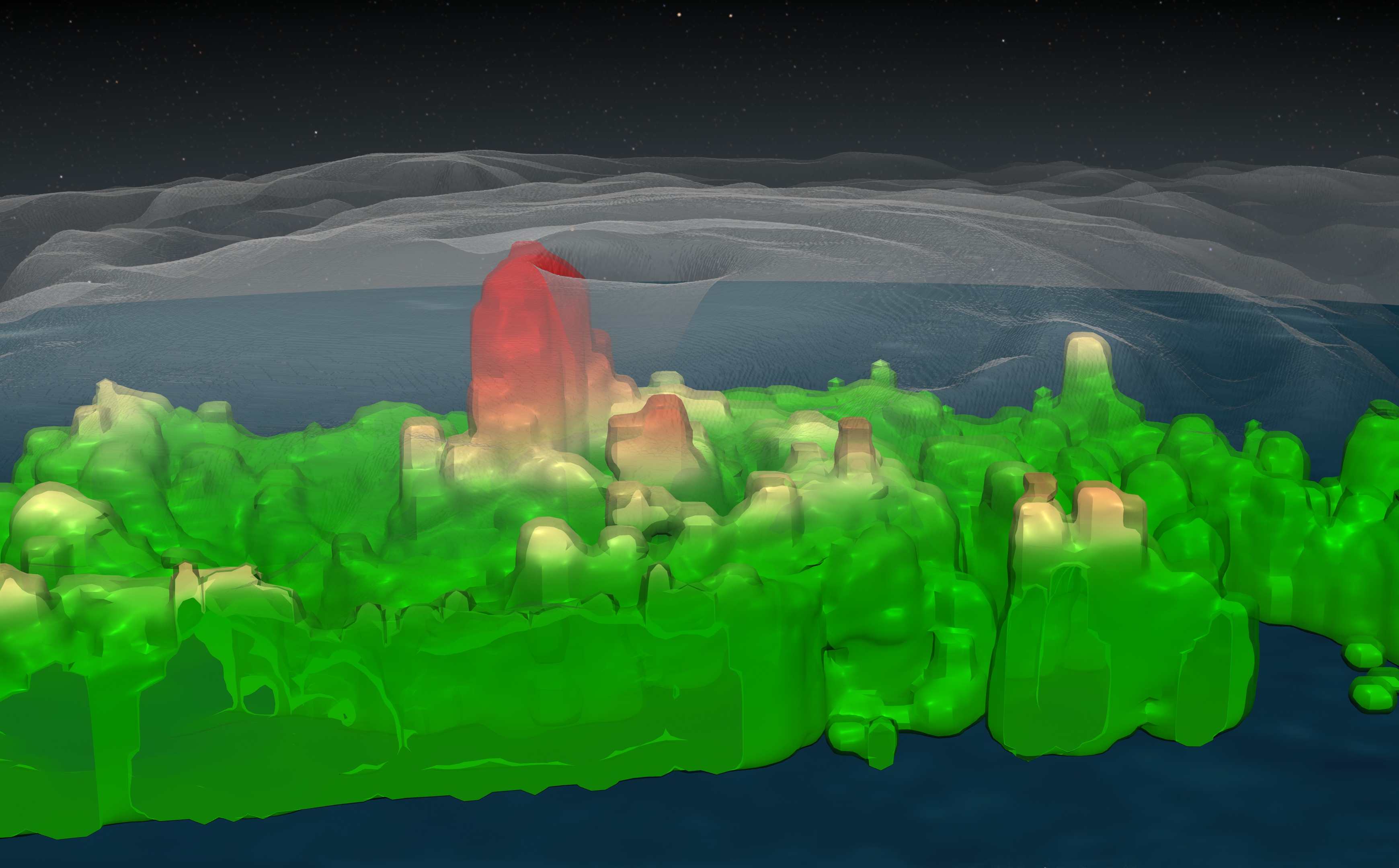


Hurricane Danielle's Hot Towers August 27,2010 Stereoscopic Version
This set provides anaglyph 3D visualization content. Red/Cyan glasses are required to view it properly.
Visualization Credits
Lori Perkins (NASA/GSFC): Lead Animator
Victoria Weeks (HTSI): Video Editor
Michael Starobin (HTSI): Producer
Jeff Halverson (JCET UMBC): Scientist
Victoria Weeks (HTSI): Video Editor
Michael Starobin (HTSI): Producer
Jeff Halverson (JCET UMBC): Scientist
Please give credit for this item to:
NASA/Goddard Space Flight Center Scientific Visualization Studio
NASA/Goddard Space Flight Center Scientific Visualization Studio
Science Paper:
http://www.nasa.gov/centers/goddard/news/topstory/2004/0112towerclouds.html
Short URL to share this page:
https://svs.gsfc.nasa.gov/3779
Mission:
Tropical Rainfall Measuring Mission - TRMM
Data Used:
Note: While we identify the data sets used in these visualizations, we do not store any further details nor the data sets themselves on our site.
This item is part of these series:
Hurricanes
TRMM 3D Hurricanes
Keywords:
DLESE >> Atmospheric science
SVS >> HDTV
DLESE >> Natural hazards
GCMD >> Earth Science >> Atmosphere >> Atmospheric Phenomena >> Hurricanes
SVS >> Stereo Display
SVS >> GOES
NASA Science >> Earth
GCMD keywords can be found on the Internet with the following citation: Olsen, L.M., G. Major, K. Shein, J. Scialdone, S. Ritz, T. Stevens, M. Morahan, A. Aleman, R. Vogel, S. Leicester, H. Weir, M. Meaux, S. Grebas, C.Solomon, M. Holland, T. Northcutt, R. A. Restrepo, R. Bilodeau, 2013. NASA/Global Change Master Directory (GCMD) Earth Science Keywords. Version 8.0.0.0.0
http://www.nasa.gov/centers/goddard/news/topstory/2004/0112towerclouds.html
Short URL to share this page:
https://svs.gsfc.nasa.gov/3779
Mission:
Tropical Rainfall Measuring Mission - TRMM
Data Used:
TRMM/PR
08/27/2010TRMM/VIRS
08/27/2010GOES-12/Imager
08/27/2010Hipparcos/Telescope/Tycho 2 Catalogue also referred to as: Tycho Catalogue
DatabaseThis item is part of these series:
Hurricanes
TRMM 3D Hurricanes
Keywords:
DLESE >> Atmospheric science
SVS >> HDTV
DLESE >> Natural hazards
GCMD >> Earth Science >> Atmosphere >> Atmospheric Phenomena >> Hurricanes
SVS >> Stereo Display
SVS >> GOES
NASA Science >> Earth
GCMD keywords can be found on the Internet with the following citation: Olsen, L.M., G. Major, K. Shein, J. Scialdone, S. Ritz, T. Stevens, M. Morahan, A. Aleman, R. Vogel, S. Leicester, H. Weir, M. Meaux, S. Grebas, C.Solomon, M. Holland, T. Northcutt, R. A. Restrepo, R. Bilodeau, 2013. NASA/Global Change Master Directory (GCMD) Earth Science Keywords. Version 8.0.0.0.0


