Earth
ID: 3746
NASA's TRMM spacecraft observed this view of Hurricane Alex on June 30, 2010 at 2103 UTC (5:02 PM EST). At this time, Hurricane Alex was increasing in intensity and had become a category 2 storm with estimated winds at 75 knots (~86.4 mph) and a pressure reading of 962 mb. The rain structure is taken by TRMM's Tropical Microwave Imager (TMI) and TRMM's Precitation Radar (PR) instruments. The TMI rainfall analysis shows that Alex had a well defined eye containing powerful thounderstorms that were dropping extreme amounts of rain. The clouds are taken by TRMM's visible-infrared radiometer (VIRS) and the National Oceanic and Atmospheric Administration (NOAA) Geostationary Operational Environmental Satellite (GOES-13) infrared instrument. TRMM looks underneath of the storm's clouds to reveal the underlying rain structure. The colored isosurface under the clouds show the rain seen by the PR instrument. Areas of extremely heavy rainfall are colored in red. Heavy rainfall are colored in yellow, moderate rainfall are colored in green, and light rain are in blue.
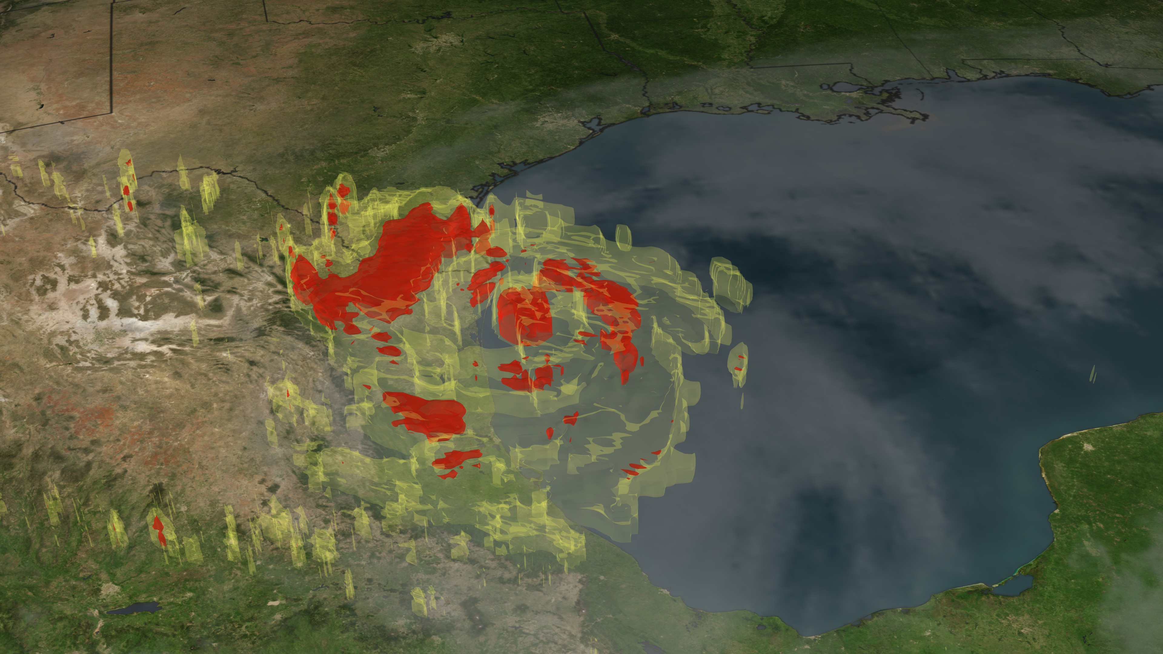
Hurricane Alex Makes Landfall in Northeastern Mexico
Visualization Credits
Lori Perkins (NASA/GSFC): Lead Animator
Scott Braun (NASA/GSFC): Scientist
Hal Pierce (SSAI): Project Support
Scott Braun (NASA/GSFC): Scientist
Hal Pierce (SSAI): Project Support
Please give credit for this item to:
NASA/Goddard Space Flight Center Scientific Visualization Studio
NASA/Goddard Space Flight Center Scientific Visualization Studio
Short URL to share this page:
https://svs.gsfc.nasa.gov/3746
Mission:
Tropical Rainfall Measuring Mission - TRMM
Data Used:
Note: While we identify the data sets used in these visualizations, we do not store any further details nor the data sets themselves on our site.
This item is part of these series:
Hurricanes
TRMM 3D Hurricanes
Keywords:
SVS >> HDTV
DLESE >> Natural hazards
GCMD >> Earth Science >> Atmosphere >> Atmospheric Phenomena >> Hurricanes
GCMD >> Earth Science >> Human Dimensions >> Natural Hazards >> Fires
SVS >> GOES
SVS >> Copenhagen
SVS >> For Educators
SVS >> Water Cycle >> Condensation
SVS >> Hurricanes >> Jeanne
NASA Science >> Earth
GCMD keywords can be found on the Internet with the following citation: Olsen, L.M., G. Major, K. Shein, J. Scialdone, S. Ritz, T. Stevens, M. Morahan, A. Aleman, R. Vogel, S. Leicester, H. Weir, M. Meaux, S. Grebas, C.Solomon, M. Holland, T. Northcutt, R. A. Restrepo, R. Bilodeau, 2013. NASA/Global Change Master Directory (GCMD) Earth Science Keywords. Version 8.0.0.0.0
https://svs.gsfc.nasa.gov/3746
Mission:
Tropical Rainfall Measuring Mission - TRMM
Data Used:
GOES
06/30/2010 2040 UTCTRMM/VIRS
06/30/2010 2103 UTCTRMM/TMI
06/30/2010 2103 UTCTRMM/PR
06/30/2010 2103 UTCThis item is part of these series:
Hurricanes
TRMM 3D Hurricanes
Keywords:
SVS >> HDTV
DLESE >> Natural hazards
GCMD >> Earth Science >> Atmosphere >> Atmospheric Phenomena >> Hurricanes
GCMD >> Earth Science >> Human Dimensions >> Natural Hazards >> Fires
SVS >> GOES
SVS >> Copenhagen
SVS >> For Educators
SVS >> Water Cycle >> Condensation
SVS >> Hurricanes >> Jeanne
NASA Science >> Earth
GCMD keywords can be found on the Internet with the following citation: Olsen, L.M., G. Major, K. Shein, J. Scialdone, S. Ritz, T. Stevens, M. Morahan, A. Aleman, R. Vogel, S. Leicester, H. Weir, M. Meaux, S. Grebas, C.Solomon, M. Holland, T. Northcutt, R. A. Restrepo, R. Bilodeau, 2013. NASA/Global Change Master Directory (GCMD) Earth Science Keywords. Version 8.0.0.0.0


