Earth
ID: 3710
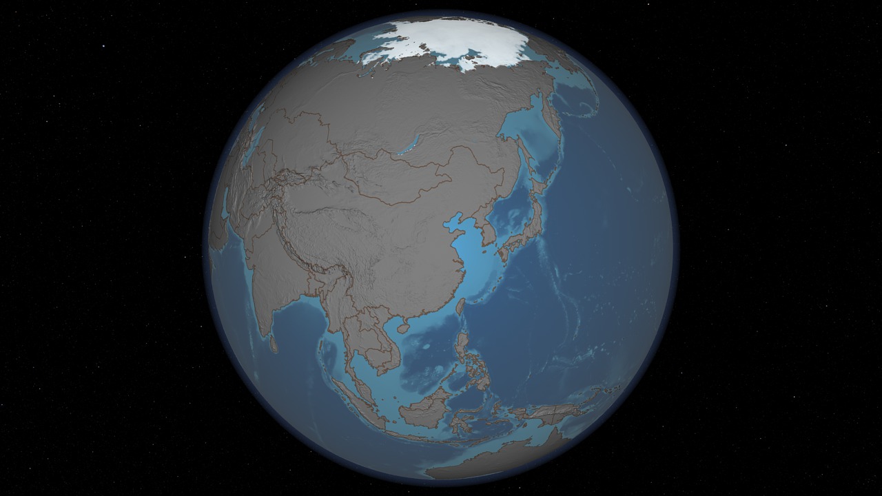
Sea ice is frozen seawater floating on the surface of the ocean. Some sea ice is semi-permanent, persisting from year to year, and some is seasonal, melting and refreezing from season to season. The sea ice cover reaches its minimum extent at the end of each summer and the remaining ice is called the perennial ice cover. The Advanced Microwave Scanning Radiometer - Earth Observing System (AMSR-E) instrument on the NASA Earth Observing System (EOS) Aqua satellite, provides data mapped to a polar stereographic grid at 12.5 km spatial resolution. This satellite data can be used to monitor the health of the cryosphere from space. This animation of sea ice changes in the Arctic is match framed to animation entries 3707, 3708, 3709, and 3711. Over the water, Arctic sea ice changes from day to day showing a running 3-day maximum sea ice concentration in the region where the concentration is greater than 15%. The blueish white color of the sea ice is derived from a 3-day running maximum of the AMSR-E 89 GHz brightness temperature. Over the terrain, monthly data from the seasonal Blue Marble Next Generation fades slowly from month to month.
Five Spheres - Cryosphere
For more information about sea ice see http://nsidc.org/data/amsre or http://modis-snow-ice.gsfc.nasa.gov.
Visualization Credits
Lori Perkins (NASA/GSFC): Lead Animator
Cindy Starr (Global Science and Technology, Inc.): Visualizer
Ivy Flores (IRC/UMBC): Video Editor
Jennifer A. Shoemaker (UMBC): Producer
Thorsten Markus (NASA/GSFC): Scientist
Cindy Starr (Global Science and Technology, Inc.): Visualizer
Ivy Flores (IRC/UMBC): Video Editor
Jennifer A. Shoemaker (UMBC): Producer
Thorsten Markus (NASA/GSFC): Scientist
Please give credit for this item to:
NASA/Goddard Space Flight Center Scientific Visualization Studio
NASA/Goddard Space Flight Center Scientific Visualization Studio
Short URL to share this page:
https://svs.gsfc.nasa.gov/3710
Mission:
Terra
Data Used:
Note: While we identify the data sets used in these visualizations, we do not store any further details nor the data sets themselves on our site.
This item is part of this series:
Know Your Earth
Keywords:
DLESE >> Cryology
SVS >> HDTV
SVS >> NDVI
DLESE >> Physical geography
SVS >> Sea Ice
GCMD >> Earth Science >> Cryosphere
GCMD >> Earth Science >> Land Surface >> Land Use/Land Cover >> Land Cover
SVS >> For Educators
SVS >> Hydrosphere >> Ice
SVS >> Seasons >> Vegetation
NASA Science >> Earth
GCMD >> Earth Science >> Solid Earth >> Geomorphic Landforms/processes >> Glacial Processes
GCMD keywords can be found on the Internet with the following citation: Olsen, L.M., G. Major, K. Shein, J. Scialdone, S. Ritz, T. Stevens, M. Morahan, A. Aleman, R. Vogel, S. Leicester, H. Weir, M. Meaux, S. Grebas, C.Solomon, M. Holland, T. Northcutt, R. A. Restrepo, R. Bilodeau, 2013. NASA/Global Change Master Directory (GCMD) Earth Science Keywords. Version 8.0.0.0.0
https://svs.gsfc.nasa.gov/3710
Mission:
Terra
Data Used:
Aqua/AMSR-E
For more information, please click http://wwwghcc.msfc.nasa.gov/AMSR/
This item is part of this series:
Know Your Earth
Keywords:
DLESE >> Cryology
SVS >> HDTV
SVS >> NDVI
DLESE >> Physical geography
SVS >> Sea Ice
GCMD >> Earth Science >> Cryosphere
GCMD >> Earth Science >> Land Surface >> Land Use/Land Cover >> Land Cover
SVS >> For Educators
SVS >> Hydrosphere >> Ice
SVS >> Seasons >> Vegetation
NASA Science >> Earth
GCMD >> Earth Science >> Solid Earth >> Geomorphic Landforms/processes >> Glacial Processes
GCMD keywords can be found on the Internet with the following citation: Olsen, L.M., G. Major, K. Shein, J. Scialdone, S. Ritz, T. Stevens, M. Morahan, A. Aleman, R. Vogel, S. Leicester, H. Weir, M. Meaux, S. Grebas, C.Solomon, M. Holland, T. Northcutt, R. A. Restrepo, R. Bilodeau, 2013. NASA/Global Change Master Directory (GCMD) Earth Science Keywords. Version 8.0.0.0.0


