Planets and Moons
ID: 3621
This animation illustrates the solution to a human factors problem in the visualization of an orbit path, in this case the launch and lunar orbit insertion of the Lunar Reconnaissance Orbiter satellite.
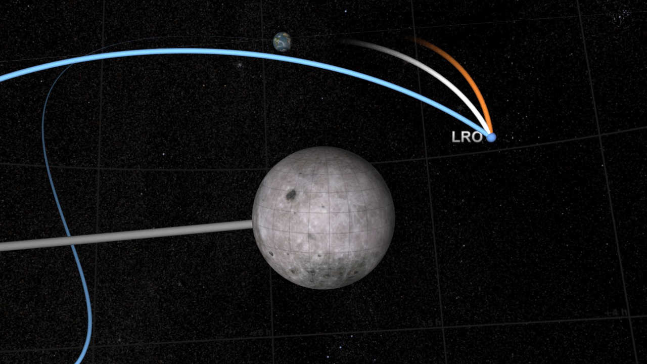
The visualization (found HERE) shows LRO orbiting the Earth, traveling from the Earth to the moon, and entering lunar orbit. Throughout the visualization, a trail is drawn to show LRO's path. This trail is a history of LRO's motion.
The viewer's expectation is that LRO first travels in a circular orbit centered on the Earth, then follows a smoothly curving path connecting the Earth to the moon, and finally enters an elliptical orbit around the moon. The problem for the animator is that an accurate trail satisfying all of these expectations is impossible to draw in a single coordinate system. A trail drawn in Earth-centered coordinates forms a looping, spring-like path when LRO enters lunar orbit, and a trail drawn in moon body-fixed coordinates becomes disconnected from the Earth and precesses through space.
Simply switching from one coordinate system to the other would make the trail appear to jump suddenly and dramatically. Creating a hybrid trail would leave a visually confusing elbow in LRO's path.
The solution illustrated here is to morph the trail from one coordinate system to the other. The blue trail is the Earth-centered path, the orange trail is the moon body-fixed path, and the white trail is the morph between the two. In the visualization, the Earth trail shortens, disconnecting it from the Earth, and then morphs over about 400 frames into the moon body-fixed trail. With careful timing, the result is a visually seamless transition from one coordinate system to the other.
Notice that the difference in coordinate systems creates no ambiguity about the present position of LRO at any given time. LRO is always at the intersection of the trails. The problem arises when attempting to depict the history of its motion. That history takes different shapes in coordinate systems that move relative to one another.
An animation showing LRO's entire path in both coordinate systems simultaneously can be found HERE.
LRO Transition from Earth-Centered to Moon-Centered Coordinates
The visualization (found HERE) shows LRO orbiting the Earth, traveling from the Earth to the moon, and entering lunar orbit. Throughout the visualization, a trail is drawn to show LRO's path. This trail is a history of LRO's motion.
The viewer's expectation is that LRO first travels in a circular orbit centered on the Earth, then follows a smoothly curving path connecting the Earth to the moon, and finally enters an elliptical orbit around the moon. The problem for the animator is that an accurate trail satisfying all of these expectations is impossible to draw in a single coordinate system. A trail drawn in Earth-centered coordinates forms a looping, spring-like path when LRO enters lunar orbit, and a trail drawn in moon body-fixed coordinates becomes disconnected from the Earth and precesses through space.
Simply switching from one coordinate system to the other would make the trail appear to jump suddenly and dramatically. Creating a hybrid trail would leave a visually confusing elbow in LRO's path.
The solution illustrated here is to morph the trail from one coordinate system to the other. The blue trail is the Earth-centered path, the orange trail is the moon body-fixed path, and the white trail is the morph between the two. In the visualization, the Earth trail shortens, disconnecting it from the Earth, and then morphs over about 400 frames into the moon body-fixed trail. With careful timing, the result is a visually seamless transition from one coordinate system to the other.
Notice that the difference in coordinate systems creates no ambiguity about the present position of LRO at any given time. LRO is always at the intersection of the trails. The problem arises when attempting to depict the history of its motion. That history takes different shapes in coordinate systems that move relative to one another.
An animation showing LRO's entire path in both coordinate systems simultaneously can be found HERE.
Visualization Credits
Greg Shirah (NASA/GSFC): Lead Animator
Ernie Wright (UMBC): Animator
Horace Mitchell (NASA/GSFC): Animator
Ernie Wright (UMBC): Animator
Horace Mitchell (NASA/GSFC): Animator
Please give credit for this item to:
NASA/Goddard Space Flight Center Scientific Visualization Studio The Blue Marble Next Generation data is courtesy of Reto Stockli (NASA/GSFC) and NASA's Earth Observatory.
NASA/Goddard Space Flight Center Scientific Visualization Studio The Blue Marble Next Generation data is courtesy of Reto Stockli (NASA/GSFC) and NASA's Earth Observatory.
Short URL to share this page:
https://svs.gsfc.nasa.gov/3621
Missions:
Clementine
LRO (Lunar Reconnaissance Orbiter)
Terra
Data Used:
Note: While we identify the data sets used in these visualizations, we do not store any further details nor the data sets themselves on our site.
Keywords:
SVS >> HDTV
SVS >> Moon
SVS >> Orbit
SVS >> LRO
SVS >> For Educators
SVS >> Satellite Orbit
NASA Science >> Planets and Moons
https://svs.gsfc.nasa.gov/3621
Missions:
Clementine
LRO (Lunar Reconnaissance Orbiter)
Terra
Data Used:
Clementine/HIRES
Terra and Aqua/MODIS/Blue Marble: Next Generation also referred to as: BMNG
1/1/2004 - 12/31/2004
Credit:
The Blue Marble data is courtesy of Reto Stockli (NASA/GSFC).
The Blue Marble data is courtesy of Reto Stockli (NASA/GSFC).
Hipparcos/Telescope/Tycho 2 Catalogue also referred to as: Tycho Catalogue
DatabaseLRO-Simulated Ephemeris
EphemerisCPC (Climate Prediction Center) Cloud Composite
Data Compilation - Climate Prediction Center (CPC)
Global cloud cover from multiple satellites
Keywords:
SVS >> HDTV
SVS >> Moon
SVS >> Orbit
SVS >> LRO
SVS >> For Educators
SVS >> Satellite Orbit
NASA Science >> Planets and Moons


