2008 Arctic Sea Ice from AMSR-E
There is a newer version of this story located here: https://svs.gsfc.nasa.gov/4684
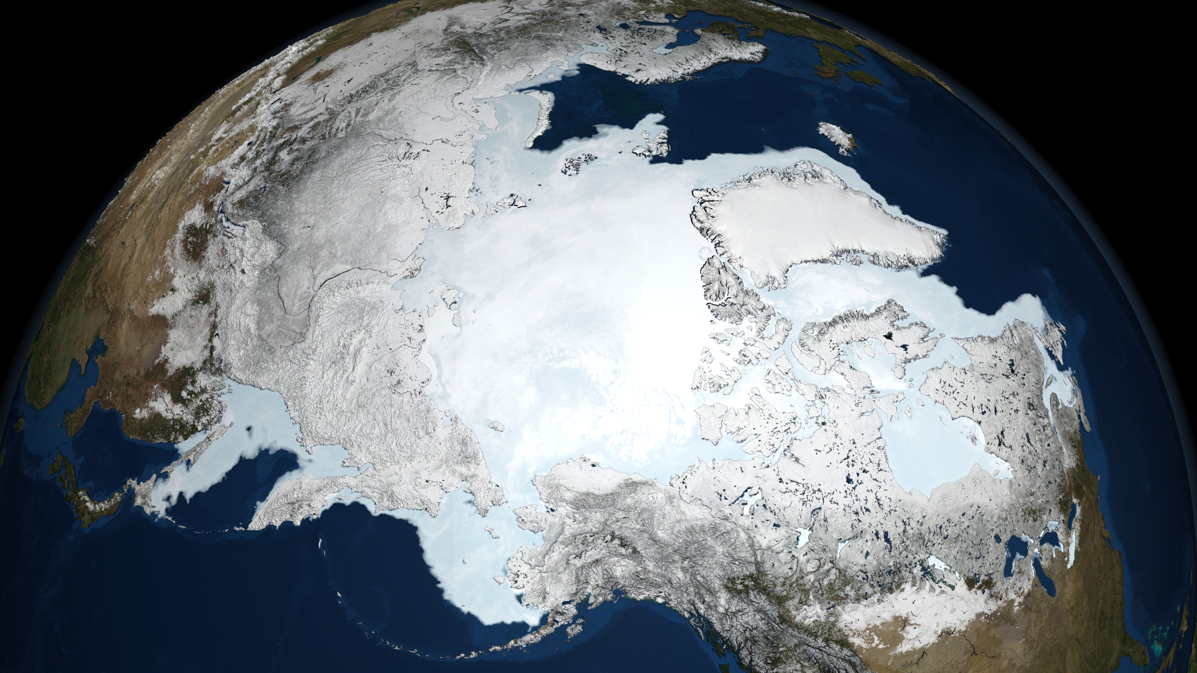
The AMSR-E instrument on the Aqua satellite acquires high resolution measurements of the 89 GHz brightness temperature near the poles. Because this is a passive microwave sensor which is not so sensitive to atmospheric effects, this sensor is able to observe the entire polar region every day, even through clouds and snowfall. The false color of the sea ice, derived from the AMSR-E 6.25 km 89 GHz brightness temperature, highlights the fissures or divergence areas in the sea ice cover by warm brightness temperatures (in blue) while cold brightness temperatures, shown in brighter white, represent consolidated sea ice. The sea ice edge is defined by the 15% ice concentration contour in the three-day moving average of the AMSR-E 12.5 km sea ice concentration data.
The animations below show the continuous motion of the Arctic sea ice during 2008, from January 1 through September 14, the week during which the Arctic sea ice reached its minimum extent. The 2008 minimum extent of 4.52 sq km (1.74 sq miles) is the second lowest extent recorded since 1979.


Newer Versions
Visualization Credits
NASA/Goddard Space Flight Center Scientific Visualization Studio The Blue Marble Next Generation data is courtesy of Reto Stockli (NASA/GSFC).
https://svs.gsfc.nasa.gov/3556
Data Used:
Aqua/AMSR-E/Daily L3 12.5km Tb, Sea Ice Concentration, and Snow Depth also referred to as: Sea Ice Concentration
2008-01-01 through 2008-09-14Aqua/AMSR-E/Daily L3 6.25 km 89 GHz Brightness Temperature (Tb)
2008-01-01 through 2008-09-14Keywords:
DLESE >> Cryology
SVS >> HDTV
DLESE >> Physical oceanography
GCMD >> Earth Science >> Cryosphere
GCMD >> Earth Science >> Cryosphere >> Sea Ice
GCMD >> Earth Science >> Cryosphere >> Snow/Ice
GCMD >> Earth Science >> Hydrosphere >> Snow/Ice
GCMD >> Earth Science >> Oceans >> Sea Ice
GCMD >> Earth Science >> Cryosphere >> Sea Ice >> Ice Extent
GCMD >> Earth Science >> Cryosphere >> Sea Ice >> Ice Growth/Melt
GCMD >> Earth Science >> Cryosphere >> Sea Ice >> Ice Types
GCMD >> Earth Science >> Cryosphere >> Sea Ice >> Pack Ice
GCMD >> Earth Science >> Cryosphere >> Sea Ice >> Sea Ice Concentration
GCMD >> Earth Science >> Cryosphere >> Sea Ice >> Sea Ice Motion
GCMD >> Earth Science >> Cryosphere >> Snow/Ice >> Freeze/Thaw
GCMD >> Earth Science >> Cryosphere >> Snow/Ice >> Ice Extent
GCMD >> Earth Science >> Cryosphere >> Snow/Ice >> Ice Growth/Melt
GCMD >> Earth Science >> Cryosphere >> Snow/Ice >> Ice Motion
GCMD >> Earth Science >> Hydrosphere >> Snow/Ice >> Ice Extent
GCMD >> Earth Science >> Hydrosphere >> Snow/Ice >> Ice Motion
GCMD >> Earth Science >> Oceans >> Sea Ice >> Ice Extent
GCMD >> Earth Science >> Oceans >> Sea Ice >> Ice Growth/Melt
GCMD >> Earth Science >> Oceans >> Sea Ice >> Pack Ice
NASA Science >> Earth
GCMD keywords can be found on the Internet with the following citation: Olsen, L.M., G. Major, K. Shein, J. Scialdone, S. Ritz, T. Stevens, M. Morahan, A. Aleman, R. Vogel, S. Leicester, H. Weir, M. Meaux, S. Grebas, C.Solomon, M. Holland, T. Northcutt, R. A. Restrepo, R. Bilodeau, 2013. NASA/Global Change Master Directory (GCMD) Earth Science Keywords. Version 8.0.0.0.0


