Earth
ID: 3216
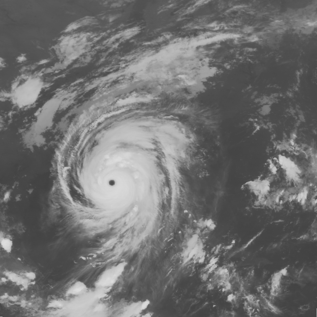
The GOES-12 satellite sits at 75 degrees west longitude at an altitude of 36,000 kilometers over the equator, in geosynchronous orbit. At this position its Imager instrument takes pictures of cloud patterns in several wavelengths for all of North and South America, a primary measurement used in weather forecasting. The Imager takes a pattern of pictures of parts of the Earth in several wavelengths all day, measurements that are vital in weather forecasting. This animation shows a four-day sequence of GOES-12 images in the longwave infrared wavelengths, from 10.2 to 11.2 microns, during the period that Hurricane Katrina passed through the Gulf of Mexico. This wavelength band is the most common one for observing cloud motions and severe storms throughout the day and night. Since GOES-12 takes images most often over the United States (every 5 to 10 minutes), the motion of the clouds in this close-up of the southeast US is very smooth.
GOES-12 Imagery of Hurricane Katrina: Longwave Infrared Close-up (WMS)
For More Information
Visualization Credits
Please give credit for this item to:
NASA/Goddard Space Flight Center Scientific Visualization Studio
NASA/Goddard Space Flight Center Scientific Visualization Studio
Short URL to share this page:
https://svs.gsfc.nasa.gov/3216
Data Used:
Note: While we identify the data sets used in these visualizations, we do not store any further details nor the data sets themselves on our site.
Dates of Data Used:
2005-08-26T23:45Z - 2005-08-30T23:45
This item is part of these series:
Hurricanes
WMS
Hurricane Katrina
Keywords:
SVS >> HDTV
GCMD >> Earth Science >> Atmosphere >> Atmospheric Phenomena >> Hurricanes
GCMD >> Earth Science >> Human Dimensions >> Natural Hazards >> Meteorological Hazards
GCMD >> Earth Science >> Spectral/Engineering >> Infrared Wavelengths >> Infrared Imagery
SVS >> Hyperwall
SVS >> GOES
NASA Science >> Earth
GCMD keywords can be found on the Internet with the following citation: Olsen, L.M., G. Major, K. Shein, J. Scialdone, S. Ritz, T. Stevens, M. Morahan, A. Aleman, R. Vogel, S. Leicester, H. Weir, M. Meaux, S. Grebas, C.Solomon, M. Holland, T. Northcutt, R. A. Restrepo, R. Bilodeau, 2013. NASA/Global Change Master Directory (GCMD) Earth Science Keywords. Version 8.0.0.0.0
https://svs.gsfc.nasa.gov/3216
Data Used:
GOES-12/Imager/Infrared
2005-08-26T23:45Z - 2005-08-30T23:45Dates of Data Used:
2005-08-26T23:45Z - 2005-08-30T23:45
This item is part of these series:
Hurricanes
WMS
Hurricane Katrina
Keywords:
SVS >> HDTV
GCMD >> Earth Science >> Atmosphere >> Atmospheric Phenomena >> Hurricanes
GCMD >> Earth Science >> Human Dimensions >> Natural Hazards >> Meteorological Hazards
GCMD >> Earth Science >> Spectral/Engineering >> Infrared Wavelengths >> Infrared Imagery
SVS >> Hyperwall
SVS >> GOES
NASA Science >> Earth
GCMD keywords can be found on the Internet with the following citation: Olsen, L.M., G. Major, K. Shein, J. Scialdone, S. Ritz, T. Stevens, M. Morahan, A. Aleman, R. Vogel, S. Leicester, H. Weir, M. Meaux, S. Grebas, C.Solomon, M. Holland, T. Northcutt, R. A. Restrepo, R. Bilodeau, 2013. NASA/Global Change Master Directory (GCMD) Earth Science Keywords. Version 8.0.0.0.0


