Earth
ID: 3171
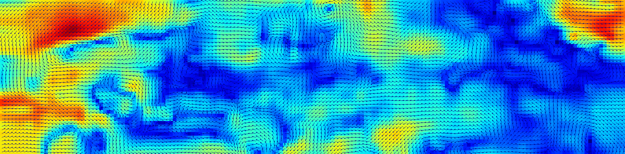
The El Niño/La Niña event in 1997-1999 was particularly intense, but was also very well observed by satellites and buoys. Deviations from normal winds speeds and directions were computed using data from the Special Sensor Microwave/Imager (SSMI) on the Tropical Rainfall Measuring Mission (TRMM) satellite.
Wind Anomalies During El Niño/La Niña Event of 1997-1998 (WMS)
Visualization Credits
Jeff de La Beaujardiere (NASA): Lead Animator
Please give credit for this item to:
NASA/Goddard Space Flight Center Scientific Visualization Studio
NASA/Goddard Space Flight Center Scientific Visualization Studio
Short URL to share this page:
https://svs.gsfc.nasa.gov/3171
Mission:
Tropical Rainfall Measuring Mission - TRMM
Data Used:
Note: While we identify the data sets used in these visualizations, we do not store any further details nor the data sets themselves on our site.
This item is part of these series:
El Niño and La Niña
WMS
Keywords:
DLESE >> Physical oceanography
GCMD >> Earth Science >> Atmosphere >> Atmospheric Winds >> Surface Winds
GCMD >> Earth Science >> Climate Indicators >> Teleconnections >> El Nino Southern Oscillation
GCMD >> Earth Science >> Oceans >> Ocean Winds >> Surface Winds
GCMD >> Location >> Pacific Ocean
NASA Science >> Earth
GCMD keywords can be found on the Internet with the following citation: Olsen, L.M., G. Major, K. Shein, J. Scialdone, S. Ritz, T. Stevens, M. Morahan, A. Aleman, R. Vogel, S. Leicester, H. Weir, M. Meaux, S. Grebas, C.Solomon, M. Holland, T. Northcutt, R. A. Restrepo, R. Bilodeau, 2013. NASA/Global Change Master Directory (GCMD) Earth Science Keywords. Version 8.0.0.0.0
https://svs.gsfc.nasa.gov/3171
Mission:
Tropical Rainfall Measuring Mission - TRMM
Data Used:
Zonal Pseudostress
Data Compilation - FSU/COAPS - 1997-01-01 through 1999-12-27, every 8 daysTRMM and DMSP/SSM/I and TMI/3B4XRT also referred to as: 3-hour Rainmap
1997-01-01 through 1999-12-27, every 8 daysThis item is part of these series:
El Niño and La Niña
WMS
Keywords:
DLESE >> Physical oceanography
GCMD >> Earth Science >> Atmosphere >> Atmospheric Winds >> Surface Winds
GCMD >> Earth Science >> Climate Indicators >> Teleconnections >> El Nino Southern Oscillation
GCMD >> Earth Science >> Oceans >> Ocean Winds >> Surface Winds
GCMD >> Location >> Pacific Ocean
NASA Science >> Earth
GCMD keywords can be found on the Internet with the following citation: Olsen, L.M., G. Major, K. Shein, J. Scialdone, S. Ritz, T. Stevens, M. Morahan, A. Aleman, R. Vogel, S. Leicester, H. Weir, M. Meaux, S. Grebas, C.Solomon, M. Holland, T. Northcutt, R. A. Restrepo, R. Bilodeau, 2013. NASA/Global Change Master Directory (GCMD) Earth Science Keywords. Version 8.0.0.0.0


