Earth
ID: 2943
Smoke from multiple large wildfires in Canada blanketed the Great Lakes and eastern United States. The enormous smoke plume was almost 200 miles wide. The thick pall affected air quality from New York, to Baltimore, and Washington, D.C. and blocked the sunlight cooling the East Coast. The first image was taken by the Moderate Resolution Imaging Spectroradiometer (MODIS) on the Terra satellite on July 7, 2002. The second image comes from NASA's Total Ozone Mapping Spectrometer (TOMS) on the Earth Probe Satellite.

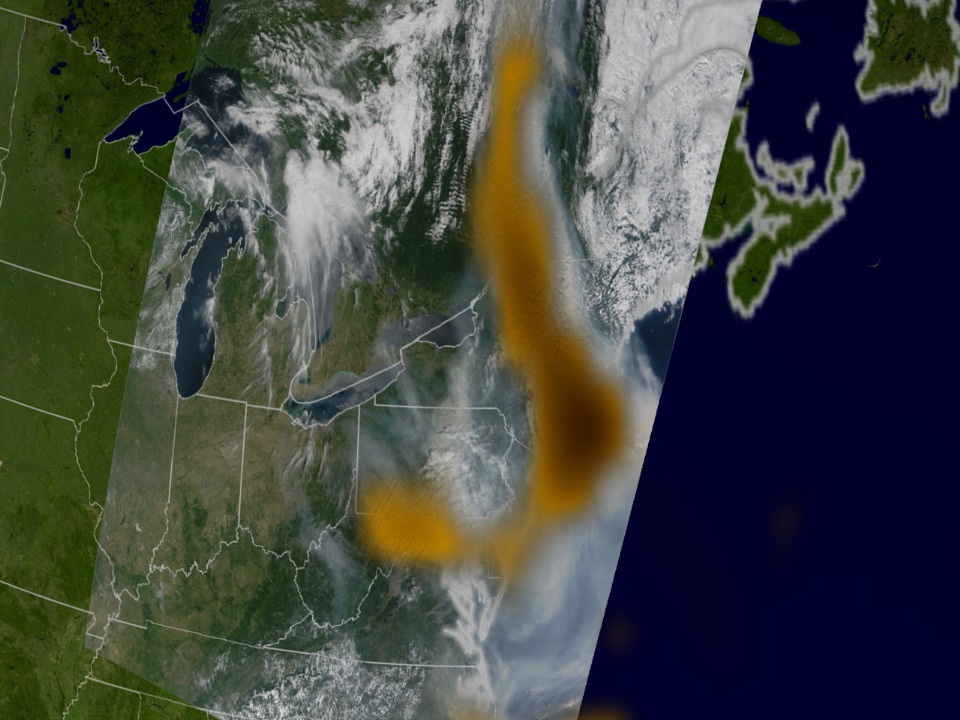
Canadian Smoke Invades the East Coast
For More Information
Visualization Credits
Please give credit for this item to:
NASA/Goddard Space Flight Center Scientific Visualization Studio
NASA/Goddard Space Flight Center Scientific Visualization Studio
Short URL to share this page:
https://svs.gsfc.nasa.gov/2943
Mission:
Terra
Data Used:
Note: While we identify the data sets used in these visualizations, we do not store any further details nor the data sets themselves on our site.
This item is part of this series:
Aura Prelaunch
Goddard TV Tapes:
G2004-020
G2008-042HD -- HD Fires, Ozone, and Air Quality RT
Keywords:
DLESE >> Atmospheric science
DLESE >> Forestry
SVS >> HDTV
DLESE >> Natural hazards
GCMD >> Earth Science >> Atmosphere >> Aerosols
GCMD >> Earth Science >> Biosphere >> Ecological Dynamics >> Fire Occurrence
GCMD >> Location >> Canada
SVS >> For Educators
SVS >> Pollutants >> Concentration
SVS >> Pollutants >> Particulates
NASA Science >> Earth
GCMD keywords can be found on the Internet with the following citation: Olsen, L.M., G. Major, K. Shein, J. Scialdone, S. Ritz, T. Stevens, M. Morahan, A. Aleman, R. Vogel, S. Leicester, H. Weir, M. Meaux, S. Grebas, C.Solomon, M. Holland, T. Northcutt, R. A. Restrepo, R. Bilodeau, 2013. NASA/Global Change Master Directory (GCMD) Earth Science Keywords. Version 8.0.0.0.0
https://svs.gsfc.nasa.gov/2943
Mission:
Terra
Data Used:
Terra/MODIS
2002/07/07Earth Probe/TOMS/Ozone
2002/07/07This item is part of this series:
Aura Prelaunch
Goddard TV Tapes:
G2004-020
G2008-042HD -- HD Fires, Ozone, and Air Quality RT
Keywords:
DLESE >> Atmospheric science
DLESE >> Forestry
SVS >> HDTV
DLESE >> Natural hazards
GCMD >> Earth Science >> Atmosphere >> Aerosols
GCMD >> Earth Science >> Biosphere >> Ecological Dynamics >> Fire Occurrence
GCMD >> Location >> Canada
SVS >> For Educators
SVS >> Pollutants >> Concentration
SVS >> Pollutants >> Particulates
NASA Science >> Earth
GCMD keywords can be found on the Internet with the following citation: Olsen, L.M., G. Major, K. Shein, J. Scialdone, S. Ritz, T. Stevens, M. Morahan, A. Aleman, R. Vogel, S. Leicester, H. Weir, M. Meaux, S. Grebas, C.Solomon, M. Holland, T. Northcutt, R. A. Restrepo, R. Bilodeau, 2013. NASA/Global Change Master Directory (GCMD) Earth Science Keywords. Version 8.0.0.0.0


