Earth
ID: 2842
Several massive wildfires were raging across southern California over the weekend of October 25, 2003. Whipped by the hot, dry Santa Ana winds that blow toward the coast from interior deserts, at least one fire grew 10,000 acres in just 6 hours. Moving northwest to southeast along the coast, the first cluster of red dots is a combination of the Piru, Verdale, and the Simi Incident Fires; The next cluster-to the east of Los Angeles-is the Grand Prix (west) and Old (east) Fires; To their south is the Roblar 2 Fire; Next is the Paradise Fire; Then the massive Cedar Fire, whose thick smoke is completely overshadowing the coastal city of San Diego; Finally, at the California-Mexico border is the Otay Fire. At least 13 people have lost their lives because of these fires, which officials are reporting were caused by carelessness and arson. Thousands have been evacuated across the region and hundreds of homes have been lost.
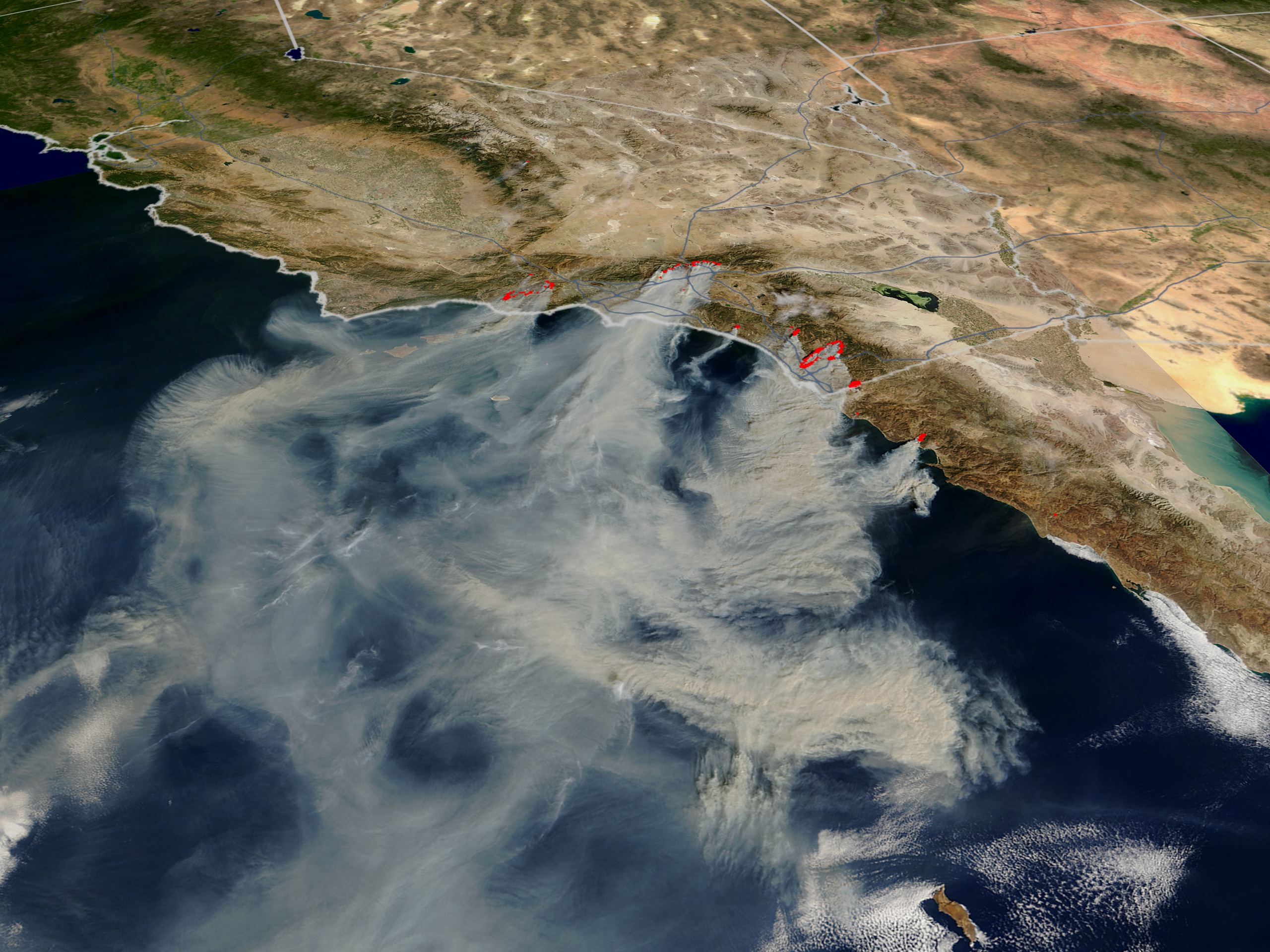

Southern California Fires, Oct 26, 2003
Visualization Credits
Lori Perkins (NASA/GSFC): Lead Animator
Greg Shirah (NASA/GSFC): Animator
Vincent Salomonson (NASA/GSFC): Scientist
Greg Shirah (NASA/GSFC): Animator
Vincent Salomonson (NASA/GSFC): Scientist
Please give credit for this item to:
NASA/Goddard Space Flight Center Scientific Visualization Studio, Jacques Descloitres, MODIS Rapid Response Team (http://rapidfire.sci.gsfc.nasa.gov)
NASA/Goddard Space Flight Center Scientific Visualization Studio, Jacques Descloitres, MODIS Rapid Response Team (http://rapidfire.sci.gsfc.nasa.gov)
Short URL to share this page:
https://svs.gsfc.nasa.gov/2842
Mission:
Terra
Data Used:
Note: While we identify the data sets used in these visualizations, we do not store any further details nor the data sets themselves on our site.
This item is part of this series:
Fires
Keywords:
DLESE >> Atmospheric science
DLESE >> Forestry
SVS >> Los Angeles
DLESE >> Natural hazards
SVS >> San Diego
GCMD >> Earth Science >> Biosphere >> Ecological Dynamics >> Fire Occurrence
GCMD >> Location >> California
NASA Science >> Earth
GCMD keywords can be found on the Internet with the following citation: Olsen, L.M., G. Major, K. Shein, J. Scialdone, S. Ritz, T. Stevens, M. Morahan, A. Aleman, R. Vogel, S. Leicester, H. Weir, M. Meaux, S. Grebas, C.Solomon, M. Holland, T. Northcutt, R. A. Restrepo, R. Bilodeau, 2013. NASA/Global Change Master Directory (GCMD) Earth Science Keywords. Version 8.0.0.0.0
Places you might have seen this:
ABC Nightly News 6:00PM on October 27, 2003
https://svs.gsfc.nasa.gov/2842
Mission:
Terra
Data Used:
Terra/MODIS
2003/10/26This item is part of this series:
Fires
Keywords:
DLESE >> Atmospheric science
DLESE >> Forestry
SVS >> Los Angeles
DLESE >> Natural hazards
SVS >> San Diego
GCMD >> Earth Science >> Biosphere >> Ecological Dynamics >> Fire Occurrence
GCMD >> Location >> California
NASA Science >> Earth
GCMD keywords can be found on the Internet with the following citation: Olsen, L.M., G. Major, K. Shein, J. Scialdone, S. Ritz, T. Stevens, M. Morahan, A. Aleman, R. Vogel, S. Leicester, H. Weir, M. Meaux, S. Grebas, C.Solomon, M. Holland, T. Northcutt, R. A. Restrepo, R. Bilodeau, 2013. NASA/Global Change Master Directory (GCMD) Earth Science Keywords. Version 8.0.0.0.0
Places you might have seen this:
ABC Nightly News 6:00PM on October 27, 2003


