Earth
ID: 2282
New NASA satellite-generated land cover maps are providing scientists with a detailed picture of the distribution of Earth's ecosystems and land use Scientists can better determine how vegetation is distributed and land is being used around the world with new NASA satellite-generated land-cover maps. These new maps, based on a global digital database of land cover types Earth images that is updated every 16 days, will help scientists better understand the Earth's climate and carbon budget and climate, through closer monitoring of water and land resources, including forested and agricultural areas.
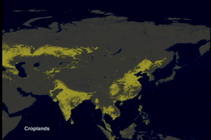
These land-coverland cover maps were developed at Boston University in Boston, MA, using data from the Moderate-resolution Imaging-Spectroradiometer (MODIS) instrument aboard NASA's Terra satellite. The prototype MODIS maps were created with data acquired between July and December 2000; but future maps will utilize one year of data. Advances in remote sensing technology allow MODIS to collect higher-quality data than previous sensors, yielding the most detailed land cover classification maps to date. The new maps are better because the quality of MODIS data is much higher than AVHRR data. They are also more current because the information content of MODIS data allowed scientists to exploit more efficient automated methods for categorizing land cover than was were previously possible, reducing the time to generate maps from months or years to about one week. Each MODIS land-coverland cover map contains 17 different land cover types, differentiating among eleven natural vegetation types such as deciduous and evergreen forests, savannas, grasslands, permanent wetlands and shrublands. Agricultural land use, as well as, several categories of land surfaces with little or no plant cover — such as bare ground, urban areas and permanent snow and ice — are also depicted in the maps. The data product is available at http://edcdaac.nasa.gov.
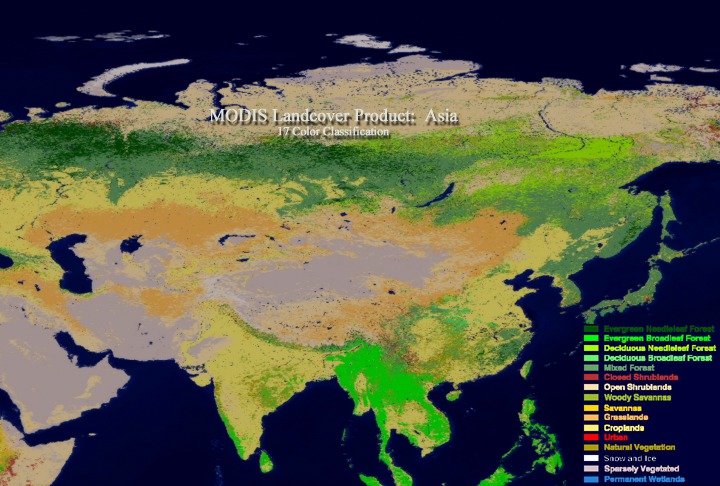
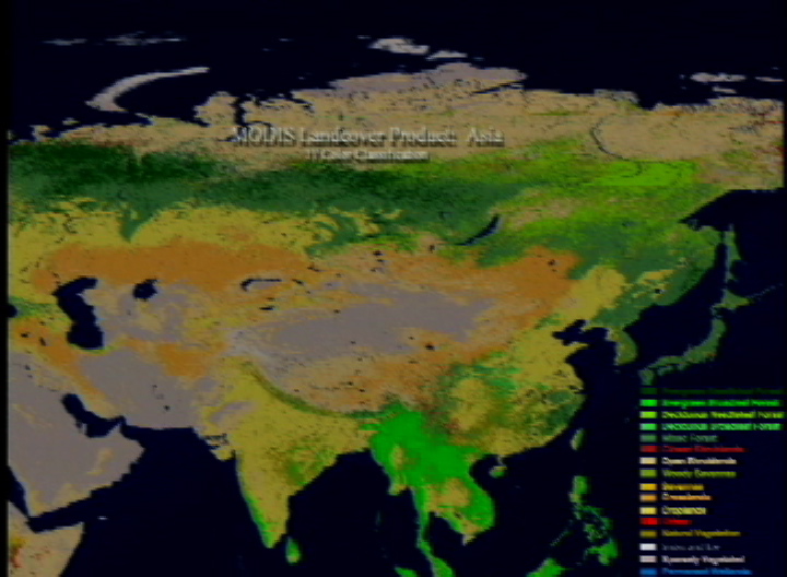
MODIS Land Cover of Asia
These land-coverland cover maps were developed at Boston University in Boston, MA, using data from the Moderate-resolution Imaging-Spectroradiometer (MODIS) instrument aboard NASA's Terra satellite. The prototype MODIS maps were created with data acquired between July and December 2000; but future maps will utilize one year of data. Advances in remote sensing technology allow MODIS to collect higher-quality data than previous sensors, yielding the most detailed land cover classification maps to date. The new maps are better because the quality of MODIS data is much higher than AVHRR data. They are also more current because the information content of MODIS data allowed scientists to exploit more efficient automated methods for categorizing land cover than was were previously possible, reducing the time to generate maps from months or years to about one week. Each MODIS land-coverland cover map contains 17 different land cover types, differentiating among eleven natural vegetation types such as deciduous and evergreen forests, savannas, grasslands, permanent wetlands and shrublands. Agricultural land use, as well as, several categories of land surfaces with little or no plant cover — such as bare ground, urban areas and permanent snow and ice — are also depicted in the maps. The data product is available at http://edcdaac.nasa.gov.
For More Information
Visualization Credits
Lori Perkins (NASA/GSFC): Lead Animator
Mark Friedl (Boston University): Scientist
John Hodges (Boston University): Scientist
Mark Friedl (Boston University): Scientist
John Hodges (Boston University): Scientist
Please give credit for this item to:
NASA/Goddard Space Flight Center Scientific Visualization Studio
NASA/Goddard Space Flight Center Scientific Visualization Studio
Short URL to share this page:
https://svs.gsfc.nasa.gov/2282
Mission:
Terra
Data Used:
Note: While we identify the data sets used in these visualizations, we do not store any further details nor the data sets themselves on our site.
This item is part of this series:
MODIS Landcover
Keywords:
DLESE >> Agricultural science
SVS >> Closed Shrublands
SVS >> Croplands
SVS >> Deciduous Broadleaf Forest
SVS >> Deciduous Needleaf Forest
SVS >> Evergreen Broadleaf Forest
SVS >> Evergreen Needleaf Forest
DLESE >> Forestry
SVS >> Grasslands
DLESE >> Human geography
SVS >> Mixed Forest
SVS >> Natural Vegetation
SVS >> Open Shrublands
SVS >> Permanent Wetlands
DLESE >> Physical geography
SVS >> Snow and Ice
SVS >> Sparsely Vegetated
SVS >> Urban
SVS >> Woody Savannas
GCMD >> Earth Science >> Biosphere >> Terrestrial Ecosystems >> Savannas
NASA Science >> Earth
GCMD keywords can be found on the Internet with the following citation: Olsen, L.M., G. Major, K. Shein, J. Scialdone, S. Ritz, T. Stevens, M. Morahan, A. Aleman, R. Vogel, S. Leicester, H. Weir, M. Meaux, S. Grebas, C.Solomon, M. Holland, T. Northcutt, R. A. Restrepo, R. Bilodeau, 2013. NASA/Global Change Master Directory (GCMD) Earth Science Keywords. Version 8.0.0.0.0
https://svs.gsfc.nasa.gov/2282
Mission:
Terra
Data Used:
Terra/MODIS
January 2001 to July 2001This item is part of this series:
MODIS Landcover
Keywords:
DLESE >> Agricultural science
SVS >> Closed Shrublands
SVS >> Croplands
SVS >> Deciduous Broadleaf Forest
SVS >> Deciduous Needleaf Forest
SVS >> Evergreen Broadleaf Forest
SVS >> Evergreen Needleaf Forest
DLESE >> Forestry
SVS >> Grasslands
DLESE >> Human geography
SVS >> Mixed Forest
SVS >> Natural Vegetation
SVS >> Open Shrublands
SVS >> Permanent Wetlands
DLESE >> Physical geography
SVS >> Snow and Ice
SVS >> Sparsely Vegetated
SVS >> Urban
SVS >> Woody Savannas
GCMD >> Earth Science >> Biosphere >> Terrestrial Ecosystems >> Savannas
NASA Science >> Earth
GCMD keywords can be found on the Internet with the following citation: Olsen, L.M., G. Major, K. Shein, J. Scialdone, S. Ritz, T. Stevens, M. Morahan, A. Aleman, R. Vogel, S. Leicester, H. Weir, M. Meaux, S. Grebas, C.Solomon, M. Holland, T. Northcutt, R. A. Restrepo, R. Bilodeau, 2013. NASA/Global Change Master Directory (GCMD) Earth Science Keywords. Version 8.0.0.0.0


