Earth
ID: 2193
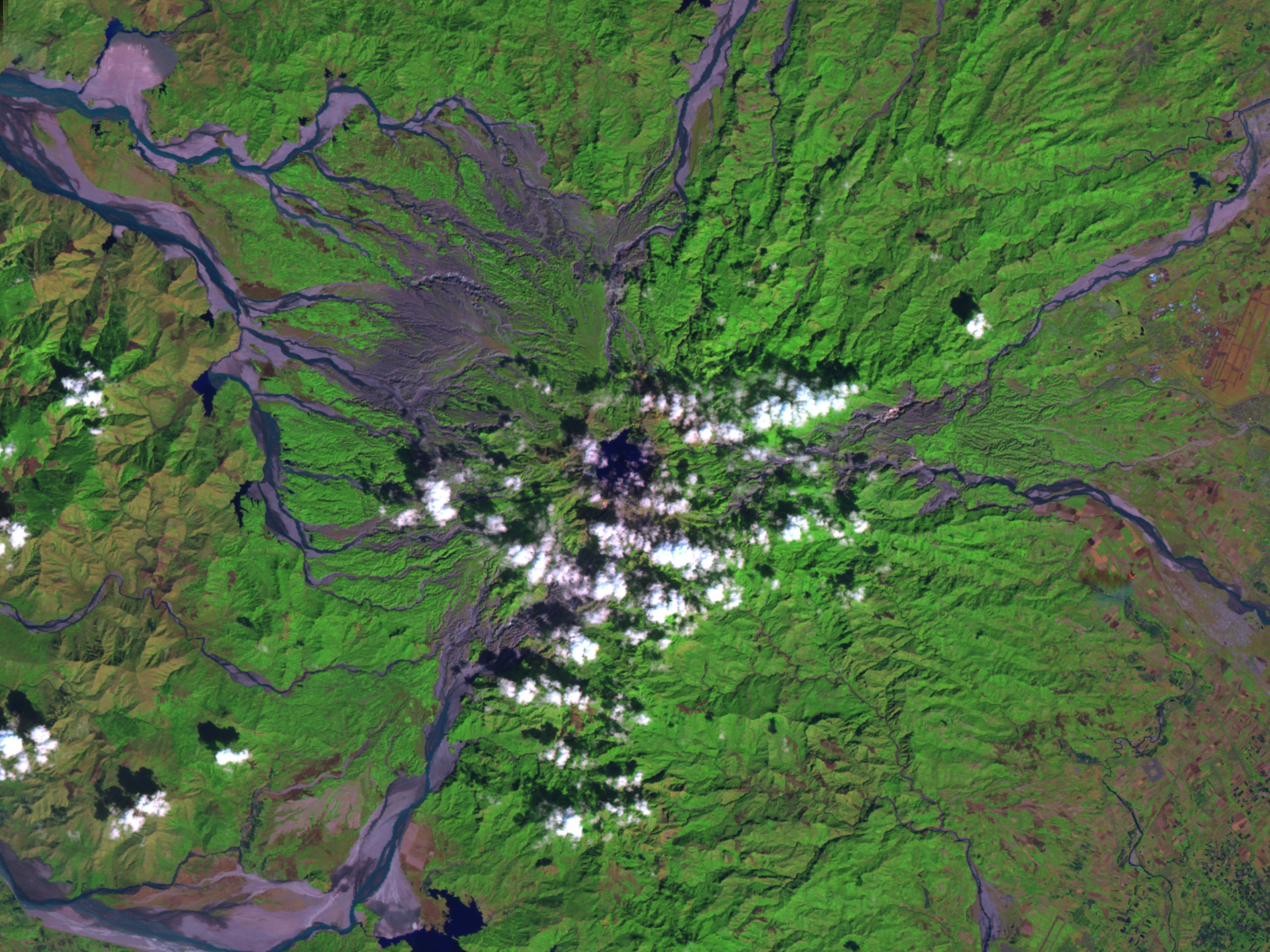
This recent false color Landsat-7 image, from January 2001, shows Mt. Pinatubo as it stands today. The caldera is seen in the middle of the image, underneath clouds.
Ten years after the blast, vegetation is re-growing on the slopes of the mountain (in green.) Streams of mud, called lahars, (resulting from ash from the eruption mixing with water- seen as the lighter sediment) continue to flow down the sides of the mountains, as well as channels of water (darker streams). However, as vegetation grows back, the ash becomes more stabilized and less likely to form the destructive lahars.

Mt. Pinatubo 10th Anniversary Perspective
Ten years after the blast, vegetation is re-growing on the slopes of the mountain (in green.) Streams of mud, called lahars, (resulting from ash from the eruption mixing with water- seen as the lighter sediment) continue to flow down the sides of the mountains, as well as channels of water (darker streams). However, as vegetation grows back, the ash becomes more stabilized and less likely to form the destructive lahars.
For More Information
Visualization Credits
Michael Mangos (GST): Lead Animator
Richard McPeters (NASA/GSFC): Scientist
Jay Herman (NASA/GSFC): Scientist
Richard McPeters (NASA/GSFC): Scientist
Jay Herman (NASA/GSFC): Scientist
Please give credit for this item to:
NASA/Goddard Space Flight Center Scientific Visualization Studio
NASA/Goddard Space Flight Center Scientific Visualization Studio
Short URL to share this page:
https://svs.gsfc.nasa.gov/2193
Mission:
Landsat
Data Used:
Note: While we identify the data sets used in these visualizations, we do not store any further details nor the data sets themselves on our site.
This item is part of this series:
Mt. Pinatubo
Keywords:
SVS >> Eruption
SVS >> Lahars
SVS >> Mt. Pinatubo
DLESE >> Natural hazards
SVS >> Volcano
GCMD >> Location >> Philippines
NASA Science >> Earth
GCMD keywords can be found on the Internet with the following citation: Olsen, L.M., G. Major, K. Shein, J. Scialdone, S. Ritz, T. Stevens, M. Morahan, A. Aleman, R. Vogel, S. Leicester, H. Weir, M. Meaux, S. Grebas, C.Solomon, M. Holland, T. Northcutt, R. A. Restrepo, R. Bilodeau, 2013. NASA/Global Change Master Directory (GCMD) Earth Science Keywords. Version 8.0.0.0.0
https://svs.gsfc.nasa.gov/2193
Mission:
Landsat
Data Used:
Landsat-7/ETM+
2001/01This item is part of this series:
Mt. Pinatubo
Keywords:
SVS >> Eruption
SVS >> Lahars
SVS >> Mt. Pinatubo
DLESE >> Natural hazards
SVS >> Volcano
GCMD >> Location >> Philippines
NASA Science >> Earth
GCMD keywords can be found on the Internet with the following citation: Olsen, L.M., G. Major, K. Shein, J. Scialdone, S. Ritz, T. Stevens, M. Morahan, A. Aleman, R. Vogel, S. Leicester, H. Weir, M. Meaux, S. Grebas, C.Solomon, M. Holland, T. Northcutt, R. A. Restrepo, R. Bilodeau, 2013. NASA/Global Change Master Directory (GCMD) Earth Science Keywords. Version 8.0.0.0.0


