Earth
ID: 2117
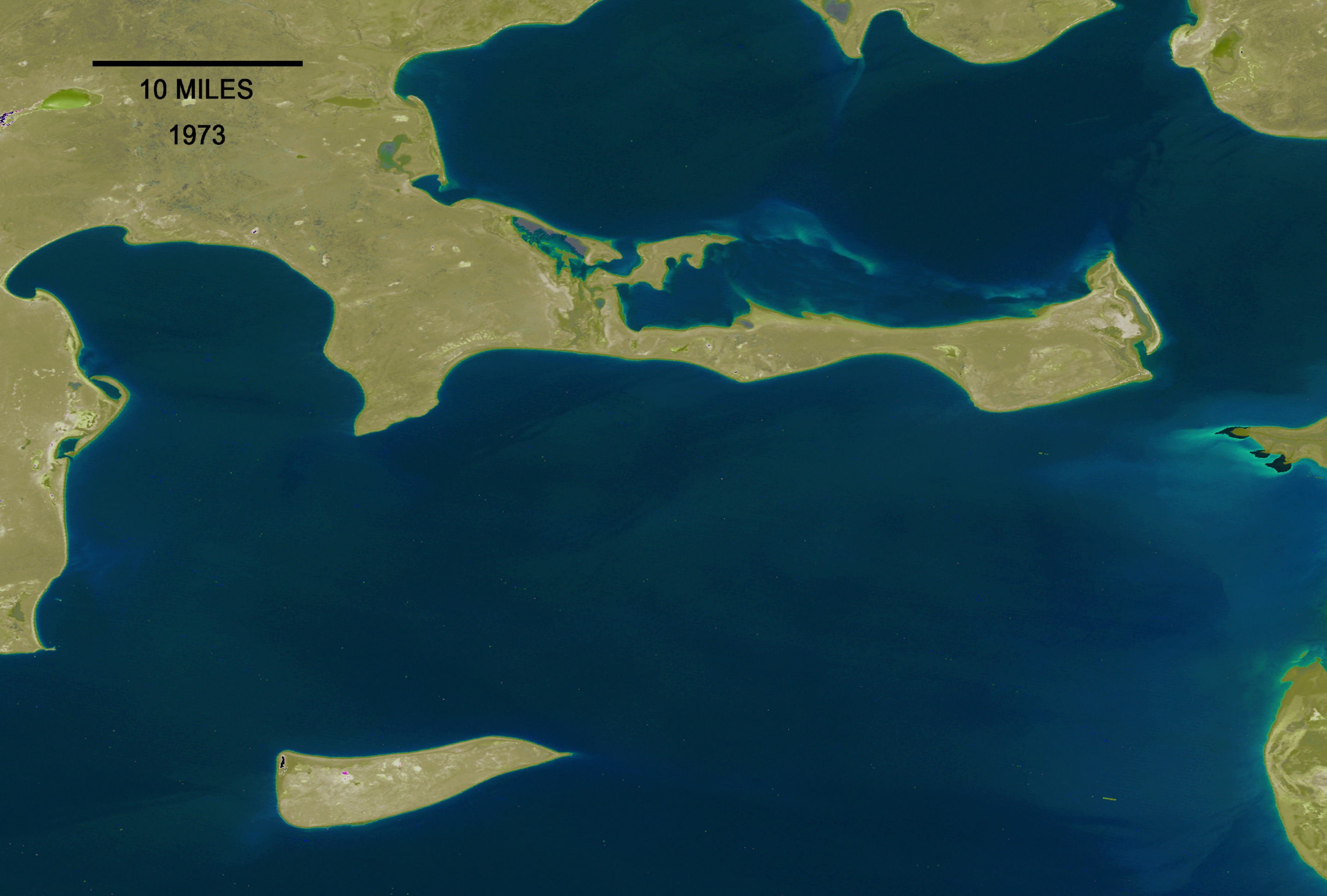
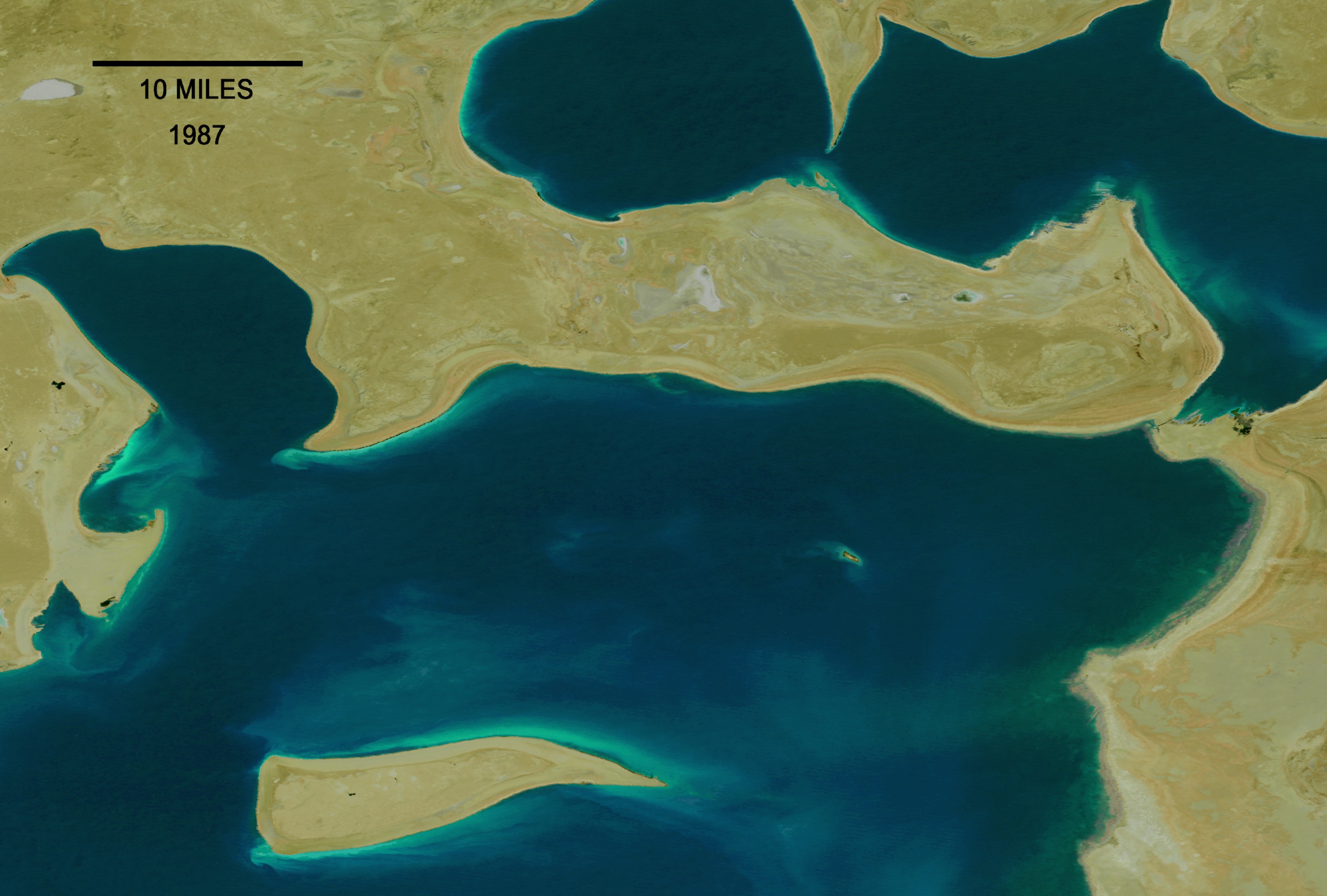
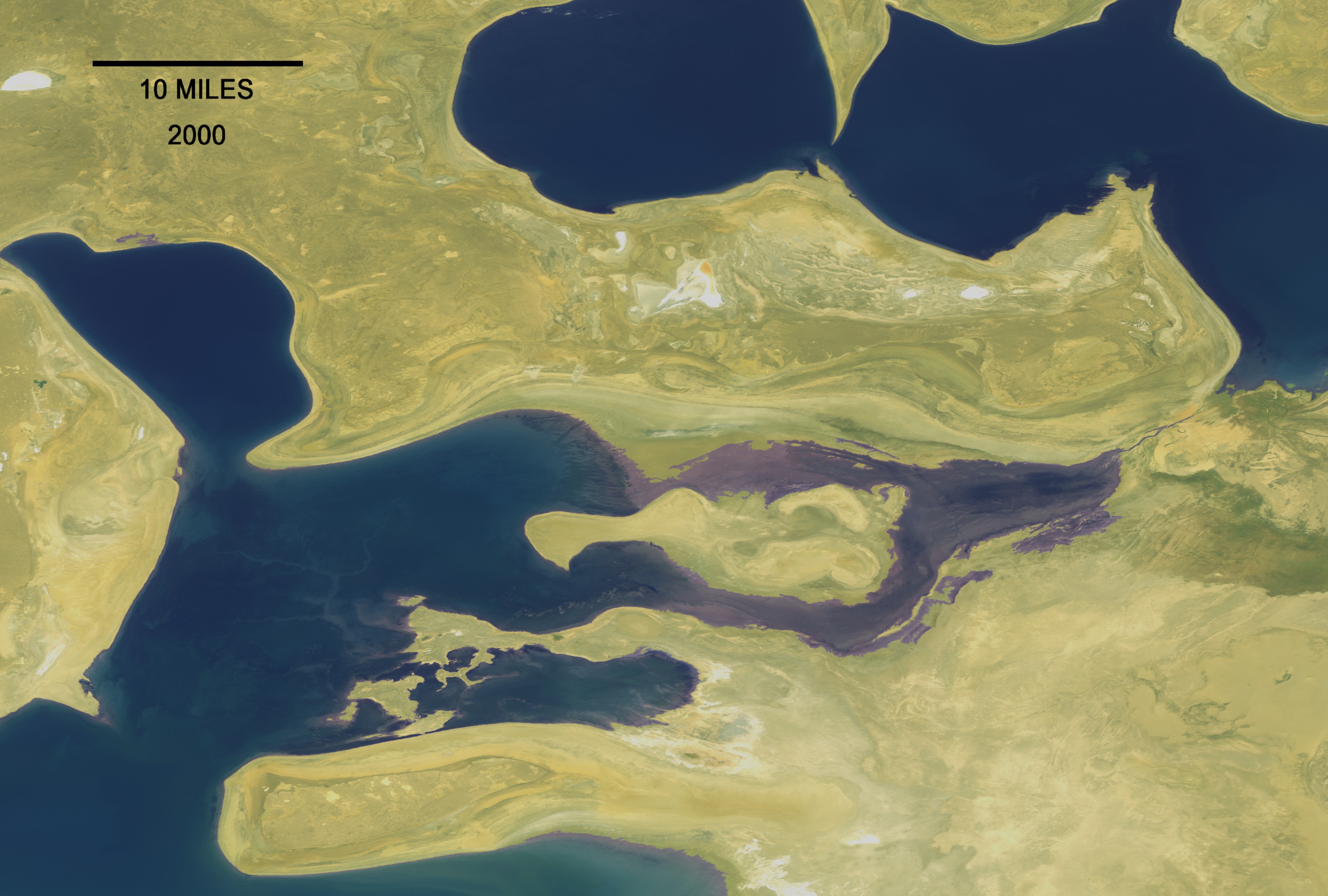
Disappearing Water: The Aral Sea Over Time (From 1973 to 2001) A time series is a powerful illustrative tool. Where in the case of Las Vegas we see the direct effects of people on the land, in the case of the Aral Sea, separating the countries of Kazakhstan and Uzbekistan, we see indirect, but no less dramatic effects on a different part of the world. The Aral Sea is actually not a sea at all. It is an immense lake, a body of fresh water, although that particular description of its contents might now be more a figure of speech than practical fact. In the last thirty years, more than sixty percent of the lake has disappeared. As you'll see in the visualization, the change over time is dramatic. In the 1970s, farmers and state offices opened significant diversions from the rivers supplying water to the lake, sending millions of gallons to irrigate cotton fields and rice paddies. So voluminous were these irrigation sluices that concentrations of salts and minerals began to rise in the shrinking body of water. That change in chemistry has led to staggering alterations in the lake's ecology, causing precipitous drops in the Aral's fish population. A secondary effect of this reduction in the Aral Sea's overall size is the rapid exposure of the lake bed. Powerful winds that blow across this part of Asia routinely pick up and deposit tens of thousands of tons of now exposed soil every year. This has not only contributed to significant reduction in breathable air quality for nearby residents, but also appreciably affected crop yields due to those heavily salt laden particles falling on arable land. In the following sequence of images, we see a series of Landsat scenes taken several years apart. As the years pass, we see the profound reduction in overall area covered by the Aral, and a commensurate increase in land area as the floor of the sea now lies exposed.
Dramatic Evaporation of the Aral Sea (With Dates)
For More Information
Visualization Credits
Please give credit for this item to:
NASA/Goddard Space Flight Center Scientific Visualization Studio
NASA/Goddard Space Flight Center Scientific Visualization Studio
Short URL to share this page:
https://svs.gsfc.nasa.gov/2117
Mission:
Landsat
Data Used:
Note: While we identify the data sets used in these visualizations, we do not store any further details nor the data sets themselves on our site.
This item is part of these series:
Geophysical Changes Over Time
Agriculture Animations - Land Use Change
Goddard TV Tapes:
G2001-059
G2002-027A
Keywords:
DLESE >> Agricultural science
DLESE >> Biology
DLESE >> Chemical oceanography
DLESE >> Chemistry
DLESE >> Human geography
DLESE >> Hydrology
GCMD >> Earth Science >> Atmosphere >> Atmospheric Water Vapor >> Evaporation
GCMD >> Location >> Aral Sea
GCMD >> Location >> Kazakhstan
GCMD >> Location >> Uzbekistan
NASA Science >> Earth
GCMD keywords can be found on the Internet with the following citation: Olsen, L.M., G. Major, K. Shein, J. Scialdone, S. Ritz, T. Stevens, M. Morahan, A. Aleman, R. Vogel, S. Leicester, H. Weir, M. Meaux, S. Grebas, C.Solomon, M. Holland, T. Northcutt, R. A. Restrepo, R. Bilodeau, 2013. NASA/Global Change Master Directory (GCMD) Earth Science Keywords. Version 8.0.0.0.0
https://svs.gsfc.nasa.gov/2117
Mission:
Landsat
Data Used:
Landsat-1/MSS
1973/05/29Landsat-4/MSS
1987/08/19Landsat-7/ETM+
2000/07/29This item is part of these series:
Geophysical Changes Over Time
Agriculture Animations - Land Use Change
Goddard TV Tapes:
G2001-059
G2002-027A
Keywords:
DLESE >> Agricultural science
DLESE >> Biology
DLESE >> Chemical oceanography
DLESE >> Chemistry
DLESE >> Human geography
DLESE >> Hydrology
GCMD >> Earth Science >> Atmosphere >> Atmospheric Water Vapor >> Evaporation
GCMD >> Location >> Aral Sea
GCMD >> Location >> Kazakhstan
GCMD >> Location >> Uzbekistan
NASA Science >> Earth
GCMD keywords can be found on the Internet with the following citation: Olsen, L.M., G. Major, K. Shein, J. Scialdone, S. Ritz, T. Stevens, M. Morahan, A. Aleman, R. Vogel, S. Leicester, H. Weir, M. Meaux, S. Grebas, C.Solomon, M. Holland, T. Northcutt, R. A. Restrepo, R. Bilodeau, 2013. NASA/Global Change Master Directory (GCMD) Earth Science Keywords. Version 8.0.0.0.0


