|
|
THIS PLANET EARTH
The Vision and Majesty of NASA's Remote Sensing Legacy
 |
 |
 |
| Washington, DC |
Atlanta, GA |
Chicago, IL |
Introduction
Sight yields insight. New observations afford new ideas, and new ideas allow for new levels of understanding. With its strong commitment to developing powerful remote sensing technologies, NASA has led the way in opening stunning vistas for exploration about our home.
Take the Landsat program, now late into its third decade. The ability to see the Earth's surface in terms that can be visually classified--"thematically mapped", to use the jargon-- have profoundly changed millions of people's lives and helped shape the future of scientific research about our home planet. Landsat 7 is the latest in a string of highly successful spacecraft. Based on the program's impressive and consistent successes, researchers have developed
daring new ideas for continuing its work into the twenty-first century.
The powerful Earth observing flagship called Terra is beginning to pay remarkable dividends to researchers around the world. With five advanced instruments designed to study the Earth as a collection of interrelated systems, the future of remote sensing is already into its dawn.
Last year an experimental satellite called EO-1 also arrived on orbit. It's designed to test next generation Landsat-type technologies, as well as try out several entirely new notions in spacecraft design. As you'll see in the following collection of images, the efforts of those involved in these programs can show us the Earth as most of us have never seen it before.
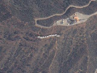
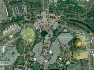
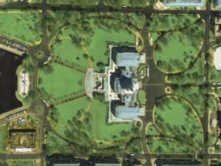
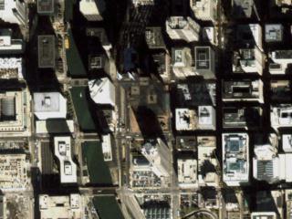
GREAT ZOOMS FROM SPACE: AMERICAN CITIES
No doubt about it: these are new. Using data from different spacecraft and some powerful computer technology, visualizers at the Goddard Space Flight Center present you with the following collection of American cities in a way you've never seen them before. Starting with our camera high above the Earth, we rush in towards the surface at what would be an impossible speed for any known vehicle. Passing though layers of atmosphere, the colors of our destinations shimmer with their own unique characteristics, and suddenly we find ourselves floating in virtual space just above the ground.
Enjoy the ride!
ZOOMS FROM SPACE: HOW DID THEY DO THAT?
There's no Earth observing telescope parked in orbit. There are no geosynchronous elevators on which a camera can be mounted. The images that went into each of the remarkable city zooms come from data collected by a group of Earth imaging satellites. And while not all of the zoom sequences use precisely the
same series of data sets, most do. Plus, those that include data from alternative sources employ techniques similar to the general case described here.
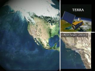
Farthest away we see the Earth as a globe. This comes from data stitched together using information from MODIS, an instrument on Terra. This first picture has a resolution of 1000 meters. As our virtual camera begins its long fall to ground, we pass through a different kind of MODIS information; data in the second layer resolves details as small as 250 meters across. Our measure of detail
has just quadrupled.
Next we find our apparent speed increasing as the surface of the Earth envelops our sense of horizon.. The data supporting this perspective comes from the land imaging workhorse of NASA's fleet: Landsat 7. These images resolve features 30 meters across.
Finally, as we rush in to the limits of Landsat 7's data capabilities, we move to our final slice of visual information. Taken by a remarkable commercial satellite called Ikonos, features as small as one meter across come into view. Individual cars, trees, and baseball diamonds appear like ghostly apparitions on the ground. In virtual space we've traveled far more than a thousand miles but in real terms, nothing besides electrons, photons, and an elite group
of computer and spacecraft personnel have moved to make these images possible.
Click Here for Page Two
Special Thanks to Dr. Jon Ranson, Terra Project Scientist and Darrel Williams, Landsat Project Scientist.
Portions of this multimedia presentation includes material
from Space Imaging L.P.
For further information about Landsat, Terra, EO-1, remote sensing, Earth science conducted by NASA and its partners, or related topics, check out the following web sites:
This multimedia project is the work of a dedicated team of researchers,
animators, and media specialists. A companion video to this web site is
available from NASA-TV. Below are a list of agencies, departments, and
researchers who provided expertise and data for this production:
NOTE: All SeaWiFs images and data presented on this website are for research and educational use only. All commercial use of SeaWiFs data must be coordinated with ORBIMAGE.
Please give credit for these images to:
NASA - Goddard Space Flight Center
Scientific Visualization Studio
Television Production NASA-TV/GSFC
The SeaWiFs Project and ORBIMAGE
Content Preparation and Project Production:
Michael Starobin
Last Revised: February 4, 2019 at 06:02 PM EST
|