Earth
ID: 12742
As wildfires burn across California, NASA satellites help gather data about where the fires are and how smoke travels across the state.
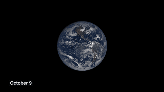
The smoke from the fires is even visible a million miles away from Earth, captured by NASA's Earth Polychromatic Imaging Camera (EPIC) onboard NOAA's Deep Space Climate Observatory (DSCOVR).
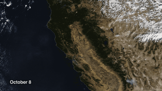
The Terra spacecraft can see fires in both daylight and at night, helping aid firefighters in tracking and stopping the blazes.
NASA's unique vantage point in space helps better understand our home planet.
Terra Imagery from NASA Worldview

NASA Satellites See Wildfires from Space
The smoke from the fires is even visible a million miles away from Earth, captured by NASA's Earth Polychromatic Imaging Camera (EPIC) onboard NOAA's Deep Space Climate Observatory (DSCOVR).
The Terra spacecraft can see fires in both daylight and at night, helping aid firefighters in tracking and stopping the blazes.
NASA's unique vantage point in space helps better understand our home planet.
Terra Imagery from NASA Worldview
Used Elsewhere In
Credits
Please give credit for this item to:
NASA's Goddard Space Flight Center
NASA's Goddard Space Flight Center
Short URL to share this page:
https://svs.gsfc.nasa.gov/12742
Keywords:
SVS >> HDTV
SVS >> Satellite
SVS >> Terra
NASA Science >> Earth
GCMD >> Earth Science >> Human Dimensions >> Natural Hazards >> Wildfires
SVS >> DSCOVR
SVS >> EPIC
GCMD keywords can be found on the Internet with the following citation: Olsen, L.M., G. Major, K. Shein, J. Scialdone, S. Ritz, T. Stevens, M. Morahan, A. Aleman, R. Vogel, S. Leicester, H. Weir, M. Meaux, S. Grebas, C.Solomon, M. Holland, T. Northcutt, R. A. Restrepo, R. Bilodeau, 2013. NASA/Global Change Master Directory (GCMD) Earth Science Keywords. Version 8.0.0.0.0


