Tracking Urban Change With Landsat
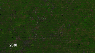
Earth-observing Landsat satellites have been capturing images of the planet’s surface since 1972. Landsat 8 is the newest satellite in the program, a joint effort between NASA and the U.S. Geological Survey. It launched Feb. 11, 2013, and collects more than 400 images per day. New and archived Landsat data are available free to the public over the internet – and researchers have put the data to a multitude of uses. One is called the National Urban Change Indicator, or NUCI, created by MacDonald, Dettwiler, and Associates, LTD. It’s the results from a process that mines Landsat images over a 27-year period to identify areas of “permanent change,” where soil has been paved over for parking lots or other concrete structures.
NUCI results act as a red flag for FEMA, helping the agency focus its mapping efforts and budget. But if maps identify a high risk of floods for a certain community, residents can take action, including elevating houses, building flood barricades, and more.
Related
Credits
Zack Roehr (Dewberry): Interviewee
Alison Schuyler Ogden (NASA/GSFC): Narrator
Matthew R. Radcliff (USRA): Producer
Alison Schuyler Ogden (NASA/GSFC): Producer
James R. Irons (NASA/GSFC): Scientist
Aaron E. Lepsch (ADNET Systems, Inc.): Project Support
Alison Schuyler Ogden (NASA/GSFC): Writer
Kate Ramsayer (Telophase): Writer
NASA's Goddard Space Flight Center
https://svs.gsfc.nasa.gov/11506
Missions:
Landsat
LDCM: Landsat Data Continuity Mission
This item is part of these series:
Narrated Movies
Landsat
LDCM
Goddard TV Tape:
G2012-118 -- FEMA Risk Maps
Keywords:
SVS >> HDTV
SVS >> Landsat
SVS >> Urban Growth
GCMD >> Earth Science >> Human Dimensions >> Environmental Impacts >> Urbanization
GCMD >> Earth Science >> Hydrosphere >> Surface Water >> Floods
DLESE >> Narrated
SVS >> LDCM
NASA Science >> Earth
GCMD >> Earth Science >> Human Dimensions >> Habitat Conversion/fragmentation >> Urbanization/urban Sprawl
GCMD >> Earth Science >> Human Dimensions >> Human Settlements >> Urban Areas
GCMD >> Earth Science >> Human Dimensions >> Natural Hazards >> Floods
GCMD >> Earth Science >> Human Dimensions >> Social Behavior >> Disaster Response
GCMD keywords can be found on the Internet with the following citation: Olsen, L.M., G. Major, K. Shein, J. Scialdone, S. Ritz, T. Stevens, M. Morahan, A. Aleman, R. Vogel, S. Leicester, H. Weir, M. Meaux, S. Grebas, C.Solomon, M. Holland, T. Northcutt, R. A. Restrepo, R. Bilodeau, 2013. NASA/Global Change Master Directory (GCMD) Earth Science Keywords. Version 8.0.0.0.0


